Tepepa elevation
Tepepa (Hidalgo, Acaxochitlán), Mexico elevation is 2193 meters and Tepepa elevation in feet is 7195 ft above sea level [src 1]. Tepepa is a populated place (feature code) with elevation that is 879 meters (2884 ft) bigger than average city elevation in Mexico.
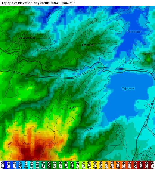
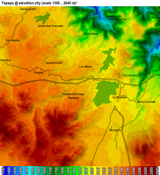
Below is the Elevation map of Tepepa, which displays elevation range with different colors. Scale of the first map is from 2053 to 2643 m (6736 to 8671 ft) with average elevation of 2229.5 meters (=7315 ft) [note 1]
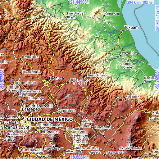
These maps also provides idea of topography and contour of this city, they are displayed at different zoom levels. More info about maps, scale and edge coordinates you can find below images.
| \ | Map #1 | Map #2 | Topo.Map |
| Scale [m] | 2053..2643 m | 1350..2645 m | × |
| Scale [ft] | 6736..8671 ft | 4429..8678 ft | × |
| Average | 2229.5 m = 7315 ft | 2208 m = 7244 ft | × |
| Width | 9.18 km = 5.7 mi | 18.35 km = 11.4 mi | 293.6 km = 182.4 mi |
| Height | 9.18 km = 5.7 mi | 18.35 km = 11.4 mi | 293.6 km = 182.4 mi |
| ↑Max Latitude | 20.175654° | 20.216898° | 21.44903° |
| Latitude at center | 20.1344° | 20.1344° | 20.1344° |
| ↓Min Latitude | 20.093135° | 20.051859° | 18.80861° |
| ← Min Longitude | -98.215255° | -98.259201° | -99.57756° |
| Longitude center | -98.17131° | -98.17131° | -98.17131° |
| →Max Longitude | -98.127365° | -98.083419° | -96.76506° |
Nearby cities:
Cities around Tepepa sort by population:
• Santa Ana Tzacuala elevation 2214 m
7.9 km,  334°
334°
• Acaxochitlán 2258 m
4.1 km,  309°
309°
• Los Reyes 2262 m
2.4 km,  17°
17°
• Beristain 2190 m
6 km,  138°
138°
• San Mateo 2291 m
9.5 km,  304°
304°
• Chimalapa 2044 m
6.1 km,  11°
11°
• Tlacomulco 2105 m
5.7 km,  68°
68°
• San Francisco Atotonilco 1782 m
7 km, 16°
• Venta Grande 2128 m
7.7 km,  102°
102°
• Chachahuantla 1744 m
8.5 km,  28°
28°
• La Boveda 2162 m
5 km, 102°
• Tlacpac 2307 m
5 km,  288°
288°
Multilingual:
 En español:
Tepepa elevación 2193 m.
 En France:
Tepepa élévation 2193 m.


Sources and notes:
- [note 1] Map square and city borders are not equal. Map elevation data is calculated only from area inside that square.
- [src 1] Elevation data from geonames database provided with same terms of usage.
- [src 2] The elevation map of Tepepa is generated using elevation data from NASA's 3 arcsec (90m) resolution SRTM data.
- [src 3] Base (background) map © OpenStreetMap contributors tiles are generated by Geofabrik and OpenTopoMap.
Copyright & License:
This Tepepa Elevation Map is licensed under CC BY-SA. You may reuse any part from this page, if you give a proper credit by linking to this URL:
 More info on terms of use page.