Balancán elevation
Balancán (Tabasco), Mexico elevation is 17 meters and Balancán elevation in feet is 56 ft above sea level [src 1]. Balancán is a seat of a second-order administrative division (feature code) with elevation that is 1297 meters (4255 ft) smaller than average city elevation in Mexico.
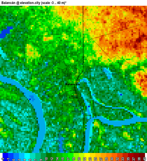
Below is the Elevation map of Balancán, which displays elevation range with different colors. Scale of the first map is from -3 to 40 m (-10 to 131 ft) with average elevation of 14.2 meters (=47 ft) [note 1]
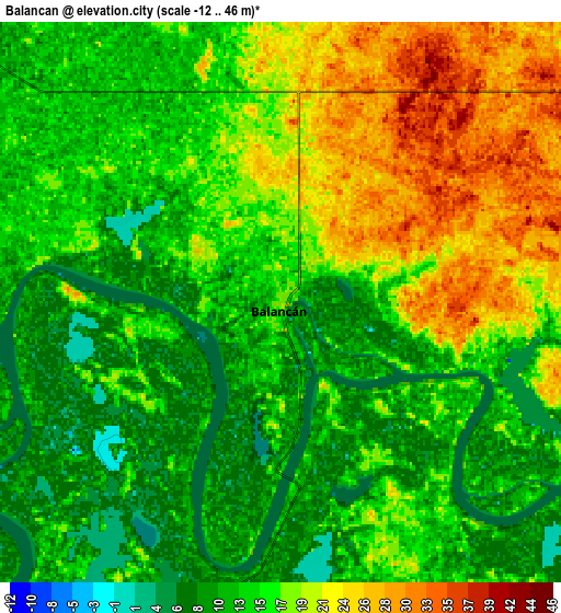
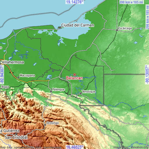
These maps also provides idea of topography and contour of this city, they are displayed at different zoom levels. More info about maps, scale and edge coordinates you can find below images.
| \ | Map #1 | Map #2 | Topo.Map |
| Scale [m] | -3..40 m | -12..46 m | × |
| Scale [ft] | -10..131 ft | -39..151 ft | × |
| Average | 14.2 m = 47 ft | 15.4 m = 51 ft | × |
| Width | 9.3 km = 5.8 mi | 18.61 km = 11.6 mi | 297.7 km = 185 mi |
| Height | 9.3 km = 5.8 mi | 18.61 km = 11.6 mi | 297.7 km = 185 mi |
| ↑Max Latitude | 17.850865° | 17.892689° | 19.14276° |
| Latitude at center | 17.80903° | 17.80903° | 17.80903° |
| ↓Min Latitude | 17.767186° | 17.725331° | 16.46525° |
| ← Min Longitude | -91.580765° | -91.624711° | -92.94307° |
| Longitude center | -91.53682° | -91.53682° | -91.53682° |
| →Max Longitude | -91.492875° | -91.448929° | -90.13057° |
Nearby cities:
Cities around Balancán sort by population:
• Tenosique elevation 33 m
39.3 km,  162°
162°
• Emiliano Zapata 27 m
25.5 km,  252°
252°
• El Triunfo 51 m
40.9 km,  72°
72°
• Chablé 11 m
26.5 km,  282°
282°
• La Libertad 31 m
23.7 km,  235°
235°
• Capitán Felipe Castellanos Díaz (San Pedro) 44 m
41.4 km,  95°
95°
• Multé 19 m
21.4 km,  128°
128°
• Arena de Hidalgo 48 m
39.4 km,  187°
187°
• Netzahualcóyotl 16 m
14.7 km,  137°
137°
• Estapilla 17 m
32.5 km,  154°
154°
• Mactún 26 m
35.5 km, 133°
• General Luis Felipe Domínguez Suárez 29 m
17 km,  179°
179°
Multilingual:
 En español:
Balancán elevación 17 m.
 En France:
Balancán élévation 17 m.


Sources and notes:
- [note 1] Map square and city borders are not equal. Map elevation data is calculated only from area inside that square.
- [src 1] Elevation data from geonames database provided with same terms of usage.
- [src 2] The elevation map of Balancán is generated using elevation data from NASA's 3 arcsec (90m) resolution SRTM data.
- [src 3] Base (background) map © OpenStreetMap contributors tiles are generated by Geofabrik and OpenTopoMap.
Copyright & License:
This Balancán Elevation Map is licensed under CC BY-SA. You may reuse any part from this page, if you give a proper credit by linking to this URL:
 More info on terms of use page.