El Triunfo elevation
El Triunfo (Tabasco, Balancán), Mexico elevation is 51 meters and El Triunfo elevation in feet is 167 ft above sea level [src 1]. El Triunfo is a populated place (feature code) with elevation that is 1263 meters (4144 ft) smaller than average city elevation in Mexico.
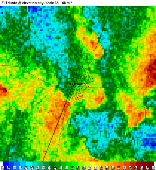
Below is the Elevation map of El Triunfo, which displays elevation range with different colors. Scale of the first map is from 36 to 68 m (118 to 223 ft) with average elevation of 49.3 meters (=162 ft) [note 1]
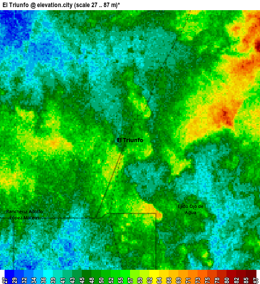
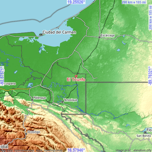
These maps also provides idea of topography and contour of this city, they are displayed at different zoom levels. More info about maps, scale and edge coordinates you can find below images.
| \ | Map #1 | Map #2 | Topo.Map |
| Scale [m] | 36..68 m | 27..87 m | × |
| Scale [ft] | 118..223 ft | 89..285 ft | × |
| Average | 49.3 m = 162 ft | 48.1 m = 158 ft | × |
| Width | 9.3 km = 5.8 mi | 18.6 km = 11.6 mi | 297.5 km = 184.9 mi |
| Height | 9.3 km = 5.8 mi | 18.6 km = 11.6 mi | 297.5 km = 184.9 mi |
| ↑Max Latitude | 17.964218° | 18.006016° | 19.25526° |
| Latitude at center | 17.92241° | 17.92241° | 17.92241° |
| ↓Min Latitude | 17.880592° | 17.838765° | 16.57946° |
| ← Min Longitude | -91.213405° | -91.257351° | -92.57571° |
| Longitude center | -91.16946° | -91.16946° | -91.16946° |
| →Max Longitude | -91.125515° | -91.081569° | -89.76321° |
Nearby cities:
Cities around El Triunfo sort by population:
• San Carlos elevation 56 m
41.2 km,  177°
177°
• Balancán 17 m
40.9 km,  252°
252°
• Candelaria 24 m
32.1 km,  24°
24°
• Capitán Felipe Castellanos Díaz (San Pedro) 44 m
16.8 km,  172°
172°
• Multé 19 m
34.2 km,  220°
220°
• Benito Juárez Uno 61 m
40.1 km,  10°
10°
• El Aguacatal 4 m
48.5 km,  311°
311°
• Netzahualcóyotl 16 m
37.3 km,  230°
230°
• Apatzingán 48 m
36.6 km,  162°
162°
• El Naranjo 65 m
12 km, 22°
• Mactún 26 m
39.2 km,  199°
199°
• Los Cenotes 51 m
34.9 km, 156°
Multilingual:
 En español:
El Triunfo, Villa el Triunfo elevación 51 m.
 En France:
El Triunfo élévation 51 m.
 Auf Deutsch:
El Triunfo höhe über dem Meeresspiegel ist 51 m.

Sources and notes:
- [note 1] Map square and city borders are not equal. Map elevation data is calculated only from area inside that square.
- [src 1] Elevation data from geonames database provided with same terms of usage.
- [src 2] The elevation map of El Triunfo is generated using elevation data from NASA's 3 arcsec (90m) resolution SRTM data.
- [src 3] Base (background) map © OpenStreetMap contributors tiles are generated by Geofabrik and OpenTopoMap.
Copyright & License:
This El Triunfo Elevation Map is licensed under CC BY-SA. You may reuse any part from this page, if you give a proper credit by linking to this URL:
 More info on terms of use page.