Buenavista elevation
Buenavista (Veracruz, Soteapan), Mexico elevation is 514 meters and Buenavista elevation in feet is 1686 ft above sea level [src 1]. Buenavista is a populated place (feature code) with elevation that is 800 meters (2625 ft) smaller than average city elevation in Mexico.
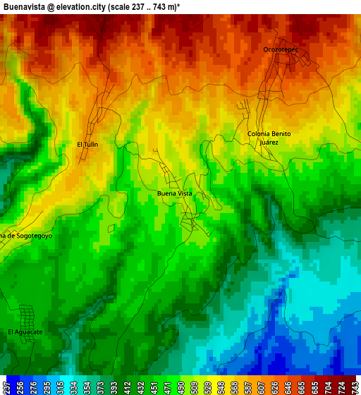
Below is the Elevation map of Buenavista, which displays elevation range with different colors. Scale of the first map is from 237 to 743 m (778 to 2438 ft) with average elevation of 489.2 meters (=1605 ft) [note 1]
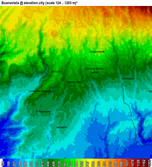
These maps also provides idea of topography and contour of this city, they are displayed at different zoom levels. More info about maps, scale and edge coordinates you can find below images.
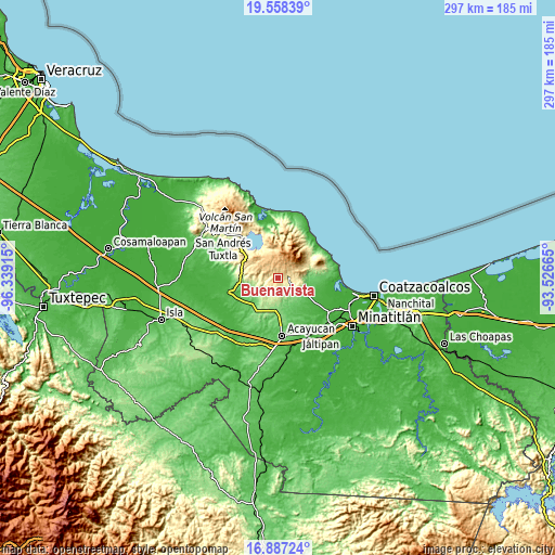
| \ | Map #1 | Map #2 | Topo.Map |
| Scale [m] | 237..743 m | 124..1203 m | × |
| Scale [ft] | 778..2438 ft | 407..3947 ft | × |
| Average | 489.2 m = 1605 ft | 496.4 m = 1629 ft | × |
| Width | 9.28 km = 5.8 mi | 18.56 km = 11.5 mi | 297 km = 184.5 mi |
| Height | 9.28 km = 5.8 mi | 18.56 km = 11.5 mi | 297 km = 184.5 mi |
| ↑Max Latitude | 18.269675° | 18.3114° | 19.55839° |
| Latitude at center | 18.22794° | 18.22794° | 18.22794° |
| ↓Min Latitude | 18.186195° | 18.14444° | 16.88724° |
| ← Min Longitude | -94.976845° | -95.020791° | -96.33915° |
| Longitude center | -94.9329° | -94.9329° | -94.9329° |
| →Max Longitude | -94.888955° | -94.845009° | -93.52665° |
Nearby cities:
Cities around Buenavista sort by population:
• Mecayapan elevation 347 m
10.1 km,  95°
95°
• Soteapan 450 m
6.4 km,  84°
84°
• Ocozotepec 670 m
4.2 km,  34°
34°
• Morelos 408 m
5.6 km,  198°
198°
• Ixhuapán 84 m
15.3 km,  112°
112°
• El Aguacate 450 m
5.2 km,  230°
230°
• San Fernando 675 m
6.8 km,  48°
48°
• El Tulín 601 m
3.1 km,  314°
314°
• Loma de Sogotegoyo 529 m
4.4 km,  256°
256°
• Tierra Nueva 355 m
9.7 km, 256°
• Saltillo 200 m
11.4 km,  132°
132°
• Ocotal Chico 608 m
8.3 km,  66°
66°
Multilingual:
 En español:
Buenavista elevación 514 m.
 En France:
Buenavista élévation 514 m.
 Auf Deutsch:
Buenavista höhe über dem Meeresspiegel ist 514 m.

Sources and notes:
- [note 1] Map square and city borders are not equal. Map elevation data is calculated only from area inside that square.
- [src 1] Elevation data from geonames database provided with same terms of usage.
- [src 2] The elevation map of Buenavista is generated using elevation data from NASA's 3 arcsec (90m) resolution SRTM data.
- [src 3] Base (background) map © OpenStreetMap contributors tiles are generated by Geofabrik and OpenTopoMap.
Copyright & License:
This Buenavista Elevation Map is licensed under CC BY-SA. You may reuse any part from this page, if you give a proper credit by linking to this URL:
 More info on terms of use page.