Calmeca elevation
Calmeca (Puebla, Tepexco), Mexico elevation is 1348 meters and Calmeca elevation in feet is 4423 ft above sea level [src 1]. Calmeca is a populated place (feature code) with elevation that is 34 meters (112 ft) bigger than average city elevation in Mexico.
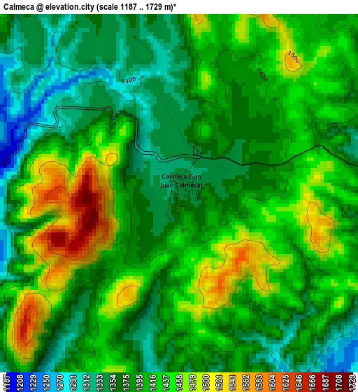
Below is the Elevation map of Calmeca, which displays elevation range with different colors. Scale of the first map is from 1187 to 1729 m (3894 to 5673 ft) with average elevation of 1401.3 meters (=4597 ft) [note 1]
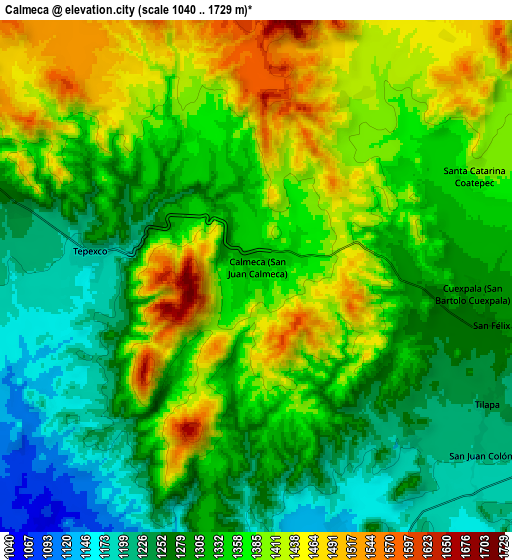
These maps also provides idea of topography and contour of this city, they are displayed at different zoom levels. More info about maps, scale and edge coordinates you can find below images.
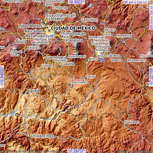
| \ | Map #1 | Map #2 | Topo.Map |
| Scale [m] | 1187..1729 m | 1040..1729 m | × |
| Scale [ft] | 3894..5673 ft | 3412..5673 ft | × |
| Average | 1401.3 m = 4597 ft | 1338.4 m = 4391 ft | × |
| Width | 9.26 km = 5.8 mi | 18.52 km = 11.5 mi | 296.3 km = 184.1 mi |
| Height | 9.26 km = 5.8 mi | 18.52 km = 11.5 mi | 296.3 km = 184.1 mi |
| ↑Max Latitude | 18.676646° | 18.718272° | 19.9622° |
| Latitude at center | 18.63501° | 18.63501° | 18.63501° |
| ↓Min Latitude | 18.593363° | 18.551707° | 17.29737° |
| ← Min Longitude | -98.678085° | -98.722031° | -100.04039° |
| Longitude center | -98.63414° | -98.63414° | -98.63414° |
| →Max Longitude | -98.590195° | -98.546249° | -97.22789° |
Nearby cities:
Cities around Calmeca sort by population:
• Tilapa elevation 1238 m
9.7 km,  115°
115°
• Tlapanalá 1414 m
12.4 km,  56°
56°
• Marcelino Rodríguez (San Ignacio) 1115 m
13.1 km,  241°
241°
• Tenango 1200 m
12.5 km,  263°
263°
• Tepexco 1194 m
6 km,  276°
276°
• Coatepec 1383 m
8.6 km,  65°
65°
• San Juan Colón 1203 m
10.3 km,  128°
128°
• Tepapayeca 1372 m
11.7 km, 70°
• Zolonquiapa 1205 m
13 km, 120°
• Cuexpala 1289 m
8 km,  96°
96°
• Atzala 1161 m
13 km,  139°
139°
• San Félix Rijo 1283 m
9 km, 100°
Multilingual:
 En español:
Calmeca, San Juan Calmeca elevación 1348 m.
 En France:
Calmeca élévation 1348 m.
 Auf Deutsch:
Calmeca höhe über dem Meeresspiegel ist 1348 m.

Sources and notes:
- [note 1] Map square and city borders are not equal. Map elevation data is calculated only from area inside that square.
- [src 1] Elevation data from geonames database provided with same terms of usage.
- [src 2] The elevation map of Calmeca is generated using elevation data from NASA's 3 arcsec (90m) resolution SRTM data.
- [src 3] Base (background) map © OpenStreetMap contributors tiles are generated by Geofabrik and OpenTopoMap.
Copyright & License:
This Calmeca Elevation Map is licensed under CC BY-SA. You may reuse any part from this page, if you give a proper credit by linking to this URL:
 More info on terms of use page.