Tepexco elevation
Tepexco (Puebla), Mexico elevation is 1194 meters and Tepexco elevation in feet is 3917 ft above sea level [src 1]. Tepexco is a populated place (feature code) with elevation that is 120 meters (394 ft) smaller than average city elevation in Mexico.
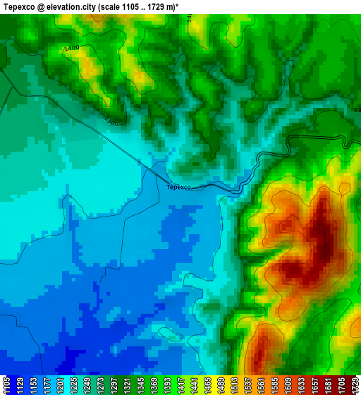
Below is the Elevation map of Tepexco, which displays elevation range with different colors. Scale of the first map is from 1105 to 1729 m (3625 to 5673 ft) with average elevation of 1300 meters (=4265 ft) [note 1]
These maps also provides idea of topography and contour of this city, they are displayed at different zoom levels. More info about maps, scale and edge coordinates you can find below images.
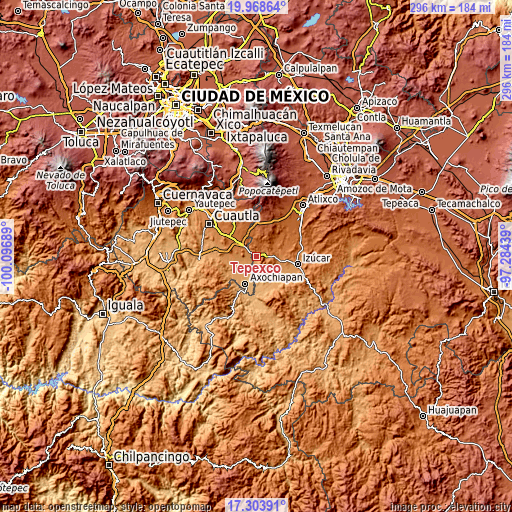
| \ | Map #1 | Topo.Map |
| Scale [m] | 1105..1729 m | × |
| Scale [ft] | 3625..5673 ft | × |
| Average | 1300 m = 4265 ft | × |
| Width | 9.26 km = 5.8 mi | 296.3 km = 184.1 mi |
| Height | 9.26 km = 5.8 mi | 296.3 km = 184.1 mi |
| ↑Max Latitude | 18.683135° | 19.96864° |
| Latitude at center | 18.6415° | 18.6415° |
| ↓Min Latitude | 18.599855° | 17.30391° |
| ← Min Longitude | -98.734585° | -100.09689° |
| Longitude center | -98.69064° | -98.69064° |
| →Max Longitude | -98.646695° | -97.28439° |
Nearby cities:
Cities around Tepexco sort by population:
• Jonacatepec elevation 1343 m
12.7 km,  290°
290°
• Calmeca 1348 m
6 km,  96°
96°
• Jantetelco 1439 m
12.5 km,  312°
312°
• Telixtac 1104 m
12.8 km,  224°
224°
• Atlacahualoya 1056 m
12 km,  200°
200°
• Tetelilla 1184 m
9.3 km,  250°
250°
• Chalcatzingo 1372 m
10.3 km,  301°
301°
• Acteopan 1666 m
13.8 km,  349°
349°
• Marcelino Rodríguez (San Ignacio) 1115 m
8.9 km, 218°
• Tenango 1200 m
6.8 km, 251°
• Coatepec 1383 m
14.1 km,  78°
78°
• Cuexpala 1289 m
14 km, 96°
Multilingual:
 En español:
Tepexco elevación 1194 m.
 En France:
Tepexco élévation 1194 m.
 Auf Deutsch:
Tepexco höhe über dem Meeresspiegel ist 1194 m.

Sources and notes:
- [note 1] Map square and city borders are not equal. Map elevation data is calculated only from area inside that square.
- [src 1] Elevation data from geonames database provided with same terms of usage.
- [src 2] The elevation map of Tepexco is generated using elevation data from NASA's 3 arcsec (90m) resolution SRTM data.
- [src 3] Base (background) map © OpenStreetMap contributors tiles are generated by Geofabrik and OpenTopoMap.
Copyright & License:
This Tepexco Elevation Map is licensed under CC BY-SA. You may reuse any part from this page, if you give a proper credit by linking to this URL:
 More info on terms of use page.