Chicontepec elevation
Chicontepec (Veracruz), Mexico elevation is 530 meters and Chicontepec elevation in feet is 1739 ft above sea level [src 1]. Chicontepec is a seat of a second-order administrative division (feature code) with elevation that is 784 meters (2572 ft) smaller than average city elevation in Mexico.
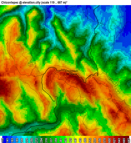
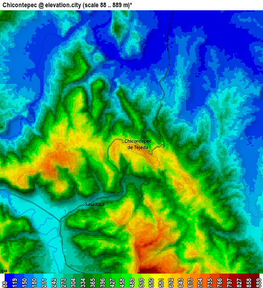
Below is the Elevation map of Chicontepec, which displays elevation range with different colors. Scale of the first map is from 119 to 687 m (390 to 2254 ft) with average elevation of 391 meters (=1283 ft) [note 1]
These maps also provides idea of topography and contour of this city, they are displayed at different zoom levels. More info about maps, scale and edge coordinates you can find below images.
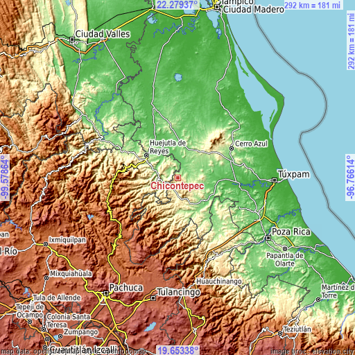
| \ | Map #1 | Map #2 | Topo.Map |
| Scale [m] | 119..687 m | 88..889 m | × |
| Scale [ft] | 390..2254 ft | 289..2917 ft | × |
| Average | 391 m = 1283 ft | 317.1 m = 1040 ft | × |
| Width | 9.13 km = 5.7 mi | 18.25 km = 11.3 mi | 292 km = 181.4 mi |
| Height | 9.13 km = 5.7 mi | 18.25 km = 11.3 mi | 292 km = 181.4 mi |
| ↑Max Latitude | 21.013169° | 21.054186° | 22.27937° |
| Latitude at center | 20.97214° | 20.97214° | 20.97214° |
| ↓Min Latitude | 20.9311° | 20.890049° | 19.65338° |
| ← Min Longitude | -98.216335° | -98.260281° | -99.57864° |
| Longitude center | -98.17239° | -98.17239° | -98.17239° |
| →Max Longitude | -98.128445° | -98.084499° | -96.76614° |
Nearby cities:
Cities around Chicontepec sort by population:
• Huautla elevation 521 m
13.6 km,  298°
298°
• Atlapexco 162 m
18.9 km,  286°
286°
• Ohuatipa 383 m
12.8 km,  226°
226°
• Pahactla 338 m
19.1 km,  270°
270°
• Colatlán 288 m
19 km,  155°
155°
• Benito Juárez 264 m
10.2 km,  200°
200°
• Tecacahuaco 334 m
17.6 km,  258°
258°
• Xochimilco 304 m
16.2 km,  138°
138°
• Oxeloco 353 m
17 km,  249°
249°
• Sasaltitla 269 m
4.8 km,  211°
211°
• Ahuateno 188 m
4.1 km,  33°
33°
• Acatepec 571 m
10.7 km, 258°
Multilingual:
 En español:
Chicontepec de Tejeda elevación 530 m.
 En France:
Chicontepec élévation 530 m.
 Auf Deutsch:
Chicontepec höhe über dem Meeresspiegel ist 530 m.

Sources and notes:
- [note 1] Map square and city borders are not equal. Map elevation data is calculated only from area inside that square.
- [src 1] Elevation data from geonames database provided with same terms of usage.
- [src 2] The elevation map of Chicontepec is generated using elevation data from NASA's 3 arcsec (90m) resolution SRTM data.
- [src 3] Base (background) map © OpenStreetMap contributors tiles are generated by Geofabrik and OpenTopoMap.
Copyright & License:
This Chicontepec Elevation Map is licensed under CC BY-SA. You may reuse any part from this page, if you give a proper credit by linking to this URL:
 More info on terms of use page.