Huautla elevation
Huautla (Hidalgo), Mexico elevation is 521 meters and Huautla elevation in feet is 1709 ft above sea level [src 1]. Huautla is a populated place (feature code) with elevation that is 793 meters (2602 ft) smaller than average city elevation in Mexico.
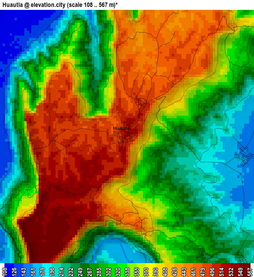
Below is the Elevation map of Huautla, which displays elevation range with different colors. Scale of the first map is from 108 to 567 m (354 to 1860 ft) with average elevation of 342.6 meters (=1124 ft) [note 1]
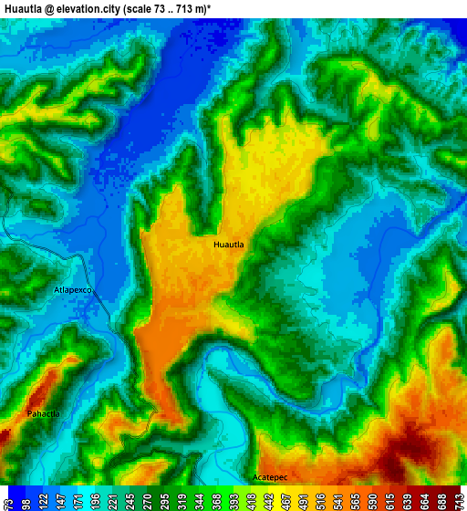
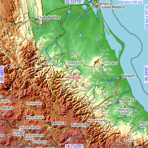
These maps also provides idea of topography and contour of this city, they are displayed at different zoom levels. More info about maps, scale and edge coordinates you can find below images.
| \ | Map #1 | Map #2 | Topo.Map |
| Scale [m] | 108..567 m | 73..713 m | × |
| Scale [ft] | 354..1860 ft | 240..2339 ft | × |
| Average | 342.6 m = 1124 ft | 292.1 m = 958 ft | × |
| Width | 9.12 km = 5.7 mi | 18.24 km = 11.3 mi | 291.9 km = 181.4 mi |
| Height | 9.12 km = 5.7 mi | 18.24 km = 11.3 mi | 291.9 km = 181.4 mi |
| ↑Max Latitude | 21.072062° | 21.113063° | 22.33775° |
| Latitude at center | 21.03105° | 21.03105° | 21.03105° |
| ↓Min Latitude | 20.990026° | 20.948992° | 19.71279° |
| ← Min Longitude | -98.330795° | -98.374741° | -99.6931° |
| Longitude center | -98.28685° | -98.28685° | -98.28685° |
| →Max Longitude | -98.242905° | -98.198959° | -96.8806° |
Nearby cities:
Cities around Huautla sort by population:
• Chicontepec elevation 530 m
13.6 km,  118°
118°
• Atlapexco 162 m
6.4 km,  258°
258°
• Tlalchiyahualica 230 m
13.5 km,  240°
240°
• Pahactla 338 m
9.6 km,  228°
228°
• Chapopote Chico 106 m
12.5 km,  18°
18°
• Yahualica 676 m
13 km, 228°
• Tecacahuaco 334 m
11.3 km,  208°
208°
• Oxeloco 353 m
13.1 km,  197°
197°
• Tepetitla 485 m
12.7 km, 232°
• Santa Catarina 164 m
12.4 km,  308°
308°
• Sasaltitla 269 m
14.2 km,  138°
138°
• Acatepec 571 m
8.7 km,  171°
171°
Multilingual:
 En español:
Huautla elevación 521 m.
 En France:
Huautla élévation 521 m.


Sources and notes:
- [note 1] Map square and city borders are not equal. Map elevation data is calculated only from area inside that square.
- [src 1] Elevation data from geonames database provided with same terms of usage.
- [src 2] The elevation map of Huautla is generated using elevation data from NASA's 3 arcsec (90m) resolution SRTM data.
- [src 3] Base (background) map © OpenStreetMap contributors tiles are generated by Geofabrik and OpenTopoMap.
Copyright & License:
This Huautla Elevation Map is licensed under CC BY-SA. You may reuse any part from this page, if you give a proper credit by linking to this URL:
 More info on terms of use page.