El Cazadero elevation
El Cazadero (Querétaro, San Juan del Río), Mexico elevation is 2258 meters and El Cazadero elevation in feet is 7408 ft above sea level [src 1]. El Cazadero is a populated place (feature code) with elevation that is 944 meters (3097 ft) bigger than average city elevation in Mexico.
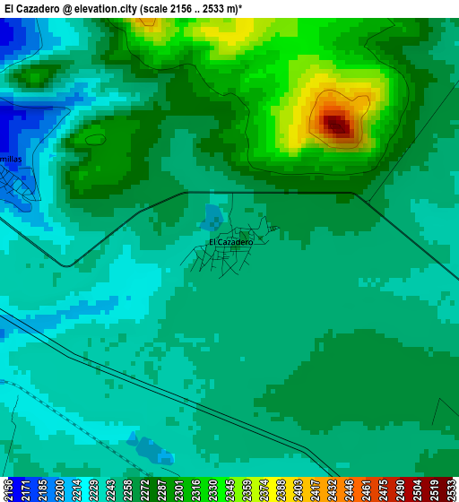
Below is the Elevation map of El Cazadero, which displays elevation range with different colors. Scale of the first map is from 2156 to 2533 m (7073 to 8310 ft) with average elevation of 2261.7 meters (=7420 ft) [note 1]
These maps also provides idea of topography and contour of this city, they are displayed at different zoom levels. More info about maps, scale and edge coordinates you can find below images.
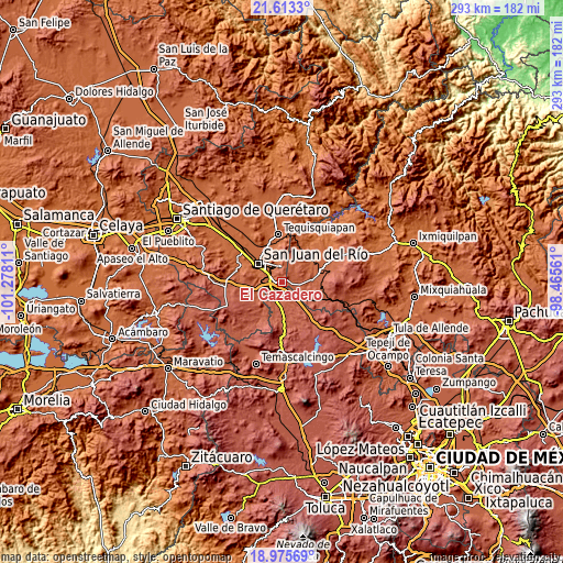
| \ | Map #1 | Topo.Map |
| Scale [m] | 2156..2533 m | × |
| Scale [ft] | 7073..8310 ft | × |
| Average | 2261.7 m = 7420 ft | × |
| Width | 9.17 km = 5.7 mi | 293.3 km = 182.2 mi |
| Height | 9.17 km = 5.7 mi | 293.3 km = 182.2 mi |
| ↑Max Latitude | 20.34132° | 21.6133° |
| Latitude at center | 20.30011° | 20.30011° |
| ↓Min Latitude | 20.258889° | 18.97569° |
| ← Min Longitude | -99.915805° | -101.27811° |
| Longitude center | -99.87186° | -99.87186° |
| →Max Longitude | -99.827915° | -98.46561° |
Nearby cities:
Cities around El Cazadero sort by population:
• Paso de Mata elevation 2126 m
7.4 km,  309°
309°
• Tlaxcalilla 2213 m
10.4 km,  34°
34°
• Polotitlán de la Ilustración 2317 m
10.2 km,  144°
144°
• Llano Largo 2239 m
11.1 km,  89°
89°
• Puerta de Palmillas 2186 m
4.8 km,  285°
285°
• Santa Bárbara de La Cueva 2183 m
9.5 km,  267°
267°
• Cerro Gordo 2046 m
9.2 km,  331°
331°
• Villas Fundadores [Fraccionamiento] 2054 m
9.5 km,  335°
335°
• Palmillas 2157 m
8.2 km,  299°
299°
• San Sebastián de Las Barrancas Sur 2203 m
7.7 km,  240°
240°
• San Pedro Denxhi Centro 2238 m
11.4 km, 240°
• Celayita 2275 m
6.6 km,  170°
170°
Multilingual:
 En español:
El Cazadero elevación 2258 m.
 En France:
El Cazadero élévation 2258 m.
 Auf Deutsch:
El Cazadero höhe über dem Meeresspiegel ist 2258 m.

Sources and notes:
- [note 1] Map square and city borders are not equal. Map elevation data is calculated only from area inside that square.
- [src 1] Elevation data from geonames database provided with same terms of usage.
- [src 2] The elevation map of El Cazadero is generated using elevation data from NASA's 3 arcsec (90m) resolution SRTM data.
- [src 3] Base (background) map © OpenStreetMap contributors tiles are generated by Geofabrik and OpenTopoMap.
Copyright & License:
This El Cazadero Elevation Map is licensed under CC BY-SA. You may reuse any part from this page, if you give a proper credit by linking to this URL:
 More info on terms of use page.