Santa Bárbara de La Cueva elevation
Santa Bárbara de La Cueva (Querétaro, San Juan del Río), Mexico elevation is 2183 meters and Santa Bárbara de La Cueva elevation in feet is 7162 ft above sea level [src 1]. Santa Bárbara de La Cueva is a populated place (feature code) with elevation that is 869 meters (2851 ft) bigger than average city elevation in Mexico.
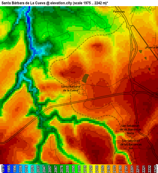
Below is the Elevation map of Santa Bárbara de La Cueva, which displays elevation range with different colors. Scale of the first map is from 1975 to 2242 m (6480 to 7356 ft) with average elevation of 2153.9 meters (=7067 ft) [note 1]
These maps also provides idea of topography and contour of this city, they are displayed at different zoom levels. More info about maps, scale and edge coordinates you can find below images.
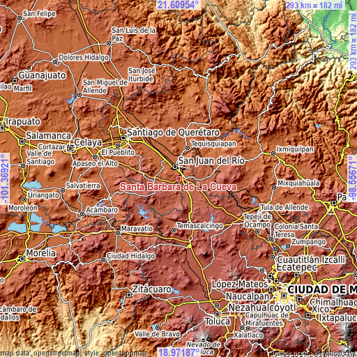
| \ | Map #1 | Topo.Map |
| Scale [m] | 1975..2242 m | × |
| Scale [ft] | 6480..7356 ft | × |
| Average | 2153.9 m = 7067 ft | × |
| Width | 9.17 km = 5.7 mi | 293.3 km = 182.2 mi |
| Height | 9.17 km = 5.7 mi | 293.3 km = 182.2 mi |
| ↑Max Latitude | 20.337531° | 21.60954° |
| Latitude at center | 20.29632° | 20.29632° |
| ↓Min Latitude | 20.255098° | 18.97187° |
| ← Min Longitude | -100.006905° | -101.36921° |
| Longitude center | -99.96296° | -99.96296° |
| →Max Longitude | -99.919015° | -98.55671° |
Nearby cities:
Cities around Santa Bárbara de La Cueva sort by population:
• San Juan del Río elevation 1923 m
10.8 km,  341°
341°
• Paso de Mata 2126 m
6.3 km,  36°
36°
• El Cazadero 2258 m
9.5 km,  87°
87°
• Puerta de Palmillas 2186 m
5.2 km,  70°
70°
• Cerro Gordo 2046 m
10 km,  30°
30°
• Villas Fundadores [Fraccionamiento] 2054 m
10.6 km, 31°
• El Jazmín 2208 m
10.2 km,  301°
301°
• Vista Hermosa (Cuasinada) 1965 m
9.6 km,  327°
327°
• Palmillas 2157 m
5 km, 27°
• Ojo de Agua 2124 m
9.4 km,  307°
307°
• San Sebastián de Las Barrancas Sur 2203 m
4.4 km,  140°
140°
• San Pedro Denxhi Centro 2238 m
5.1 km,  185°
185°
Multilingual:
 En español:
Santa Bárbara de La Cueva elevación 2183 m.
 En France:
Santa Bárbara de La Cueva élévation 2183 m.
 Auf Deutsch:
Santa Bárbara de La Cueva höhe über dem Meeresspiegel ist 2183 m.
 На русском:
Santa Bárbara de La Cueva высота над уровнем моря 2183 м
Sources and notes:
- [note 1] Map square and city borders are not equal. Map elevation data is calculated only from area inside that square.
- [src 1] Elevation data from geonames database provided with same terms of usage.
- [src 2] The elevation map of Santa Bárbara de La Cueva is generated using elevation data from NASA's 3 arcsec (90m) resolution SRTM data.
- [src 3] Base (background) map © OpenStreetMap contributors tiles are generated by Geofabrik and OpenTopoMap.
Copyright & License:
This Santa Bárbara de La Cueva Elevation Map is licensed under CC BY-SA. You may reuse any part from this page, if you give a proper credit by linking to this URL:
 More info on terms of use page.