Hueyotlipan elevation
Hueyotlipan (Tlaxcala), Mexico elevation is 2580 meters and Hueyotlipan elevation in feet is 8465 ft above sea level [src 1]. Hueyotlipan is a seat of a second-order administrative division (feature code) with elevation that is 1266 meters (4154 ft) bigger than average city elevation in Mexico.
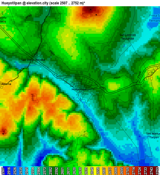
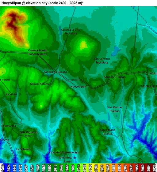
Below is the Elevation map of Hueyotlipan, which displays elevation range with different colors. Scale of the first map is from 2507 to 2752 m (8225 to 9029 ft) with average elevation of 2601.3 meters (=8534 ft) [note 1]
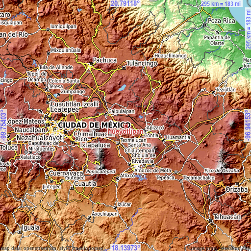
These maps also provides idea of topography and contour of this city, they are displayed at different zoom levels. More info about maps, scale and edge coordinates you can find below images.
| \ | Map #1 | Map #2 | Topo.Map |
| Scale [m] | 2507..2752 m | 2400..3028 m | × |
| Scale [ft] | 8225..9029 ft | 7874..9934 ft | × |
| Average | 2601.3 m = 8534 ft | 2591.6 m = 8503 ft | × |
| Width | 9.21 km = 5.7 mi | 18.43 km = 11.5 mi | 294.8 km = 183.2 mi |
| Height | 9.21 km = 5.7 mi | 18.43 km = 11.5 mi | 294.8 km = 183.2 mi |
| ↑Max Latitude | 19.512307° | 19.553723° | 20.79118° |
| Latitude at center | 19.47088° | 19.47088° | 19.47088° |
| ↓Min Latitude | 19.429443° | 19.387995° | 18.13973° |
| ← Min Longitude | -98.391725° | -98.435671° | -99.75403° |
| Longitude center | -98.34778° | -98.34778° | -98.34778° |
| →Max Longitude | -98.303835° | -98.259889° | -96.94153° |
Nearby cities:
Cities around Hueyotlipan sort by population:
• Sanctórum elevation 2742 m
13.2 km,  280°
280°
• San Simeón Xipetzingo 2638 m
5.8 km,  79°
79°
• Huiloapan 2566 m
12.4 km,  138°
138°
• San Simón Tlatlahuquitepec 2551 m
15.3 km,  121°
121°
• San Lucas Tecopilco 2588 m
9.8 km, 79°
• Españita 2653 m
8.1 km,  263°
263°
• San Francisco Temetzontla 2574 m
14.8 km,  155°
155°
• Muñoz 2488 m
14.5 km,  88°
88°
• Ignacio Zaragoza 2524 m
11.4 km,  343°
343°
• San José Cuamantzingo 2498 m
11 km,  63°
63°
• San Lorenzo Sóltepec 2536 m
15.3 km,  13°
13°
• Xaltocan 2445 m
15.3 km,  109°
109°
Multilingual:
 En español:
Hueyotlipan elevación 2580 m.
 En France:
Hueyotlipan élévation 2580 m.
 Auf Deutsch:
Hueyotlipan höhe über dem Meeresspiegel ist 2580 m.

Sources and notes:
- [note 1] Map square and city borders are not equal. Map elevation data is calculated only from area inside that square.
- [src 1] Elevation data from geonames database provided with same terms of usage.
- [src 2] The elevation map of Hueyotlipan is generated using elevation data from NASA's 3 arcsec (90m) resolution SRTM data.
- [src 3] Base (background) map © OpenStreetMap contributors tiles are generated by Geofabrik and OpenTopoMap.
Copyright & License:
This Hueyotlipan Elevation Map is licensed under CC BY-SA. You may reuse any part from this page, if you give a proper credit by linking to this URL:
 More info on terms of use page.