Ixcuinquitlapilco elevation
Ixcuinquitlapilco (Hidalgo, San Agustín Tlaxiaca), Mexico elevation is 2246 meters and Ixcuinquitlapilco elevation in feet is 7369 ft above sea level [src 1]. Ixcuinquitlapilco is a populated place (feature code) with elevation that is 932 meters (3058 ft) bigger than average city elevation in Mexico.
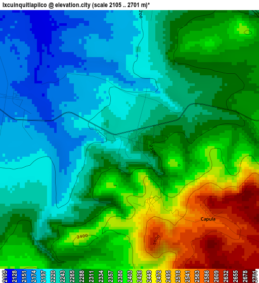
Below is the Elevation map of Ixcuinquitlapilco, which displays elevation range with different colors. Scale of the first map is from 2105 to 2701 m (6906 to 8862 ft) with average elevation of 2307.2 meters (=7570 ft) [note 1]
These maps also provides idea of topography and contour of this city, they are displayed at different zoom levels. More info about maps, scale and edge coordinates you can find below images.
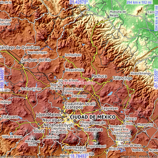
| \ | Map #1 | Topo.Map |
| Scale [m] | 2105..2701 m | × |
| Scale [ft] | 6906..8862 ft | × |
| Average | 2307.2 m = 7570 ft | × |
| Width | 9.18 km = 5.7 mi | 293.6 km = 182.4 mi |
| Height | 9.18 km = 5.7 mi | 293.7 km = 182.5 mi |
| ↑Max Latitude | 20.15217° | 21.42575° |
| Latitude at center | 20.11091° | 20.11091° |
| ↓Min Latitude | 20.069639° | 18.78493° |
| ← Min Longitude | -98.983745° | -100.34605° |
| Longitude center | -98.9398° | -98.9398° |
| →Max Longitude | -98.895855° | -97.53355° |
Nearby cities:
Cities around Ixcuinquitlapilco sort by population:
• San Agustín Tlaxiaca elevation 2368 m
5.6 km,  85°
85°
• Santiago Tlapacoya 2507 m
11.4 km, 90°
• Chicavasco 2076 m
9.7 km,  351°
351°
• El Arenal 2050 m
12.8 km,  14°
14°
• El Huaxtho 2001 m
13.9 km, 350°
• El Huixmí 2458 m
13.1 km,  107°
107°
• San Nicolás Tecomatlán 2189 m
12.6 km,  307°
307°
• San Juan Solís 2208 m
5.3 km, 9°
• Vicente Guerrero 2137 m
13.7 km,  296°
296°
• Benito Juárez 2478 m
13.1 km,  65°
65°
• El Colorado 2059 m
13.3 km,  330°
330°
• La Sala (La Caliente) 2144 m
12.8 km,  33°
33°
Multilingual:
 En español:
Ixcuinquitlapilco elevación 2246 m.
 En France:
Ixcuinquitlapilco élévation 2246 m.
 Auf Deutsch:
Ixcuinquitlapilco höhe über dem Meeresspiegel ist 2246 m.
 На русском:
Ixcuinquitlapilco высота над уровнем моря 2246 м
Sources and notes:
- [note 1] Map square and city borders are not equal. Map elevation data is calculated only from area inside that square.
- [src 1] Elevation data from geonames database provided with same terms of usage.
- [src 2] The elevation map of Ixcuinquitlapilco is generated using elevation data from NASA's 3 arcsec (90m) resolution SRTM data.
- [src 3] Base (background) map © OpenStreetMap contributors tiles are generated by Geofabrik and OpenTopoMap.
Copyright & License:
This Ixcuinquitlapilco Elevation Map is licensed under CC BY-SA. You may reuse any part from this page, if you give a proper credit by linking to this URL:
 More info on terms of use page.