Mazatán elevation
Mazatán (Chiapas), Mexico elevation is 22 meters and Mazatán elevation in feet is 72 ft above sea level [src 1]. Mazatán is a seat of a second-order administrative division (feature code) with elevation that is 1292 meters (4239 ft) smaller than average city elevation in Mexico.
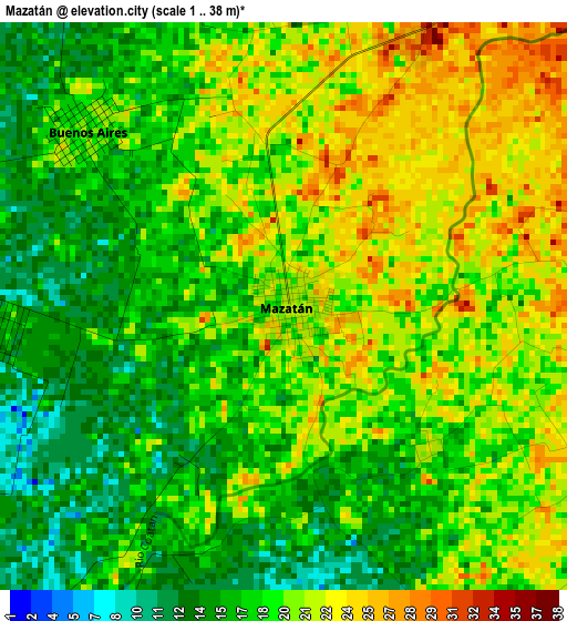
Below is the Elevation map of Mazatán, which displays elevation range with different colors. Scale of the first map is from 1 to 38 m (3 to 125 ft) with average elevation of 18.8 meters (=62 ft) [note 1]
These maps also provides idea of topography and contour of this city, they are displayed at different zoom levels. More info about maps, scale and edge coordinates you can find below images.
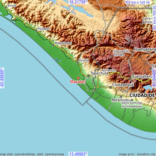
| \ | Map #1 | Map #2 | Topo.Map |
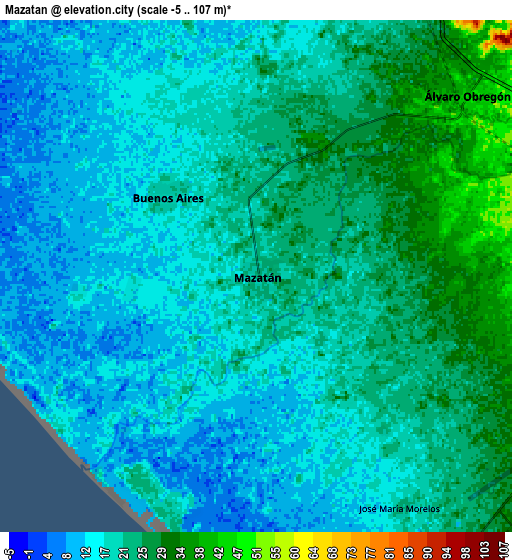
| Scale [m] | 1..38 m | -5..107 m | × |
| Scale [ft] | 3..125 ft | -16..351 ft | × |
| Average | 18.8 m = 62 ft | 19.4 m = 64 ft | × |
| Width | 9.45 km = 5.9 mi | 18.89 km = 11.7 mi | 302.2 km = 187.8 mi |
| Height | 9.45 km = 5.9 mi | 18.89 km = 11.7 mi | 302.3 km = 187.8 mi |
| ↑Max Latitude | 14.905661° | 14.948123° | 16.21799° |
| Latitude at center | 14.86319° | 14.86319° | 14.86319° |
| ↓Min Latitude | 14.820711° | 14.778223° | 13.49983° |
| ← Min Longitude | -92.494245° | -92.538191° | -93.85655° |
| Longitude center | -92.4503° | -92.4503° | -92.4503° |
| →Max Longitude | -92.406355° | -92.362409° | -91.04405° |
Nearby cities:
Cities around Mazatán sort by population:
• Puerto Madero elevation 10 m
16.1 km,  168°
168°
• Vida Mejor I 89 m
15.3 km,  87°
87°
• Álvaro Obregón 47 m
10.2 km,  49°
49°
• Buenos Aires 18 m
4.4 km,  311°
311°
• Los Cafetales 94 m
15.9 km, 88°
• Raymundo Enríquez 85 m
14.6 km, 88°
• El Encanto 8 m
15.3 km,  163°
163°
• Viva México 88 m
14.3 km,  68°
68°
• Plan de Ayala 14 m
13.7 km,  348°
348°
• Nuevo Pumpuapa (Cereso) 45 m
11.5 km, 52°
• Marte R. Gómez 20 m
7.1 km,  5°
5°
• Aquiles Serdán 11 m
11 km,  321°
321°
Multilingual:
 En español:
Mazatán elevación 22 m.
 En France:
Mazatán élévation 22 m.


Sources and notes:
- [note 1] Map square and city borders are not equal. Map elevation data is calculated only from area inside that square.
- [src 1] Elevation data from geonames database provided with same terms of usage.
- [src 2] The elevation map of Mazatán is generated using elevation data from NASA's 3 arcsec (90m) resolution SRTM data.
- [src 3] Base (background) map © OpenStreetMap contributors tiles are generated by Geofabrik and OpenTopoMap.
Copyright & License:
This Mazatán Elevation Map is licensed under CC BY-SA. You may reuse any part from this page, if you give a proper credit by linking to this URL:
 More info on terms of use page.