Molango elevation
Molango (Hidalgo, Molango de Escamilla), Mexico elevation is 1617 meters and Molango elevation in feet is 5305 ft above sea level [src 1]. Molango is a populated place (feature code) with elevation that is 303 meters (994 ft) bigger than average city elevation in Mexico.
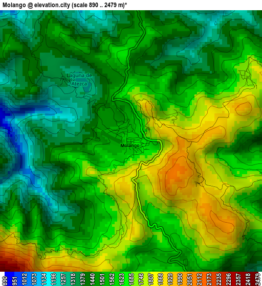
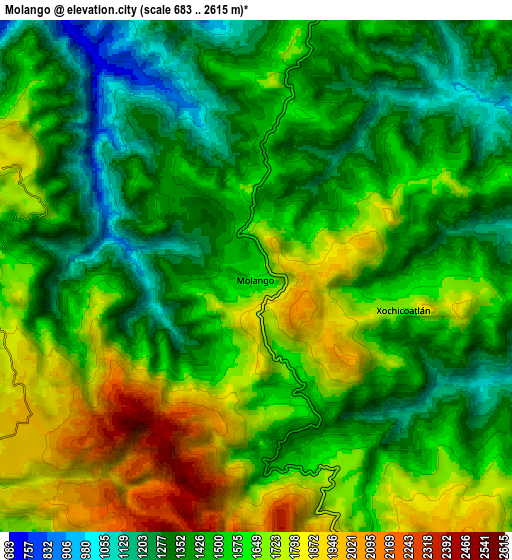
Below is the Elevation map of Molango, which displays elevation range with different colors. Scale of the first map is from 890 to 2479 m (2920 to 8133 ft) with average elevation of 1557.8 meters (=5111 ft) [note 1]
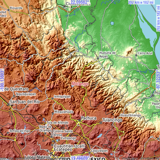
These maps also provides idea of topography and contour of this city, they are displayed at different zoom levels. More info about maps, scale and edge coordinates you can find below images.
| \ | Map #1 | Map #2 | Topo.Map |
| Scale [m] | 890..2479 m | 683..2615 m | × |
| Scale [ft] | 2920..8133 ft | 2241..8579 ft | × |
| Average | 1557.8 m = 5111 ft | 1541.6 m = 5058 ft | × |
| Width | 9.14 km = 5.7 mi | 18.27 km = 11.4 mi | 292.3 km = 181.6 mi |
| Height | 9.14 km = 5.7 mi | 18.27 km = 11.4 mi | 292.4 km = 181.7 mi |
| ↑Max Latitude | 20.828009° | 20.869077° | 22.09582° |
| Latitude at center | 20.78693° | 20.78693° | 20.78693° |
| ↓Min Latitude | 20.74584° | 20.704738° | 19.46659° |
| ← Min Longitude | -98.772725° | -98.816671° | -100.13503° |
| Longitude center | -98.72878° | -98.72878° | -98.72878° |
| →Max Longitude | -98.684835° | -98.640889° | -97.32253° |
Nearby cities:
Cities around Molango sort by population:
• Zacualtipán elevation 1990 m
17 km,  153°
153°
• Calnali 929 m
19.3 km,  50°
50°
• Metztitlán 1316 m
21.6 km,  189°
189°
• Tianguistengo 1645 m
12 km,  123°
123°
• San Andrés (San Andrés Chichayotla) 1164 m
23.2 km, 47°
• Xochicoatlán 1681 m
5.2 km,  102°
102°
• Ixtlahuaca 1426 m
11.1 km,  13°
13°
• Texcaco 1073 m
13.1 km,  63°
63°
• Chichatla 1095 m
21.7 km,  28°
28°
• Acoxcatlán 1137 m
21.4 km,  346°
346°
• Hualula 1491 m
14.2 km,  232°
232°
• Tlahuelompa (San Francisco Tlahuelompa) 1674 m
22 km,  133°
133°
Multilingual:
 En español:
Molango elevación 1617 m.
 En France:
Molango élévation 1617 m.
 Auf Deutsch:
Molango höhe über dem Meeresspiegel ist 1617 m.

Sources and notes:
- [note 1] Map square and city borders are not equal. Map elevation data is calculated only from area inside that square.
- [src 1] Elevation data from geonames database provided with same terms of usage.
- [src 2] The elevation map of Molango is generated using elevation data from NASA's 3 arcsec (90m) resolution SRTM data.
- [src 3] Base (background) map © OpenStreetMap contributors tiles are generated by Geofabrik and OpenTopoMap.
Copyright & License:
This Molango Elevation Map is licensed under CC BY-SA. You may reuse any part from this page, if you give a proper credit by linking to this URL:
 More info on terms of use page.