Motozintla elevation
Motozintla (Chiapas), Mexico elevation is 1267 meters and Motozintla elevation in feet is 4157 ft above sea level [src 1]. Motozintla is a seat of a second-order administrative division (feature code) with elevation that is 47 meters (154 ft) smaller than average city elevation in Mexico.
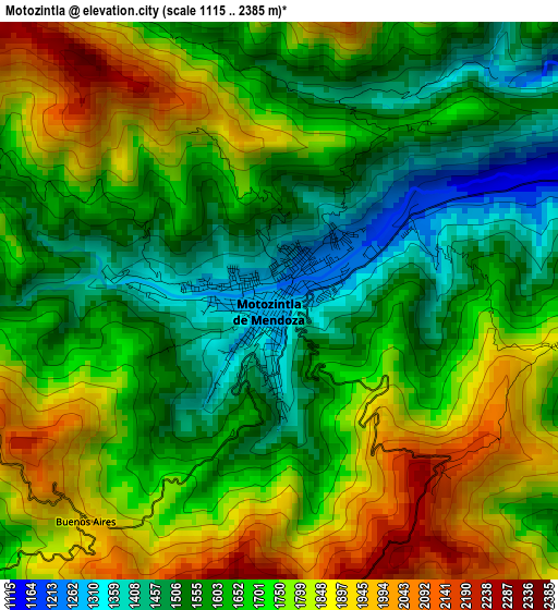
Below is the Elevation map of Motozintla, which displays elevation range with different colors. Scale of the first map is from 1115 to 2385 m (3658 to 7825 ft) with average elevation of 1687.2 meters (=5535 ft) [note 1]
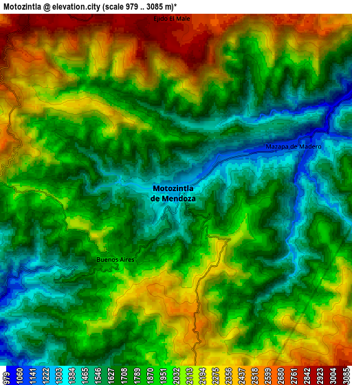
These maps also provides idea of topography and contour of this city, they are displayed at different zoom levels. More info about maps, scale and edge coordinates you can find below images.
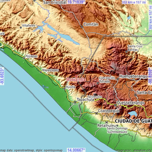
| \ | Map #1 | Map #2 | Topo.Map |
| Scale [m] | 1115..2385 m | 979..3085 m | × |
| Scale [ft] | 3658..7825 ft | 3212..10121 ft | × |
| Average | 1687.2 m = 5535 ft | 1897.9 m = 6227 ft | × |
| Width | 9.42 km = 5.9 mi | 18.85 km = 11.7 mi | 301.5 km = 187.3 mi |
| Height | 9.42 km = 5.9 mi | 18.85 km = 11.7 mi | 301.5 km = 187.3 mi |
| ↑Max Latitude | 15.40931° | 15.451671° | 16.71839° |
| Latitude at center | 15.36694° | 15.36694° | 15.36694° |
| ↓Min Latitude | 15.324561° | 15.282174° | 14.00667° |
| ← Min Longitude | -92.289995° | -92.333941° | -93.6523° |
| Longitude center | -92.24605° | -92.24605° | -92.24605° |
| →Max Longitude | -92.202105° | -92.158159° | -90.8398° |
Nearby cities:
Cities around Motozintla sort by population:
• Siltepec elevation 1566 m
22.7 km,  338°
338°
• Belisario Domínguez 694 m
16.3 km,  242°
242°
• Nuevo Amatenango 862 m
21.5 km,  42°
42°
• Mazapa 1094 m
6.7 km,  69°
69°
• El Porvenir de Velasco Suárez 2849 m
10.6 km, 340°
• Libertad Ventanas 2159 m
19.5 km,  350°
350°
• El Palmar Grande 2630 m
14.7 km,  356°
356°
• La Grandeza 1959 m
16.1 km,  7°
7°
• Pavencul 2011 m
19.6 km,  158°
158°
• Vega del Rosario 1741 m
18.3 km, 339°
• Amatenango de la Frontera 906 m
15.9 km,  61°
61°
• Bejucal de Ocampo 2334 m
13.6 km, 43°
Multilingual:
 En español:
Motozintla elevación 1267 m.
 En France:
Motozintla élévation 1267 m.
 Auf Deutsch:
Motozintla höhe über dem Meeresspiegel ist 1267 m.

Sources and notes:
- [note 1] Map square and city borders are not equal. Map elevation data is calculated only from area inside that square.
- [src 1] Elevation data from geonames database provided with same terms of usage.
- [src 2] The elevation map of Motozintla is generated using elevation data from NASA's 3 arcsec (90m) resolution SRTM data.
- [src 3] Base (background) map © OpenStreetMap contributors tiles are generated by Geofabrik and OpenTopoMap.
Copyright & License:
This Motozintla Elevation Map is licensed under CC BY-SA. You may reuse any part from this page, if you give a proper credit by linking to this URL:
 More info on terms of use page.