Nuevo Amatenango elevation
Nuevo Amatenango (Chiapas, Amatenango de la Frontera), Mexico elevation is 862 meters and Nuevo Amatenango elevation in feet is 2828 ft above sea level [src 1]. Nuevo Amatenango is a populated place (feature code) with elevation that is 452 meters (1483 ft) smaller than average city elevation in Mexico.
Below is the Elevation map of Nuevo Amatenango, which displays elevation range with different colors. Scale of the first map is from 716 to 2610 m (2349 to 8563 ft) with average elevation of 1377.1 meters (=4518 ft) [note 1]
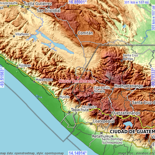
These maps also provides idea of topography and contour of this city, they are displayed at different zoom levels. More info about maps, scale and edge coordinates you can find below images.
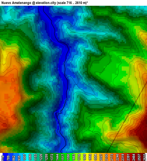
| \ | Map #1 | Topo.Map |
| Scale [m] | 716..2610 m | × |
| Scale [ft] | 2349..8563 ft | × |
| Average | 1377.1 m = 4518 ft | × |
| Width | 9.42 km = 5.9 mi | 301.3 km = 187.2 mi |
| Height | 9.42 km = 5.9 mi | 301.3 km = 187.2 mi |
| ↑Max Latitude | 15.550861° | 16.85901° |
| Latitude at center | 15.50852° | 15.50852° |
| ↓Min Latitude | 15.46617° | 14.14914° |
| ← Min Longitude | -92.153525° | -93.51583° |
| Longitude center | -92.10958° | -92.10958° |
| →Max Longitude | -92.065635° | -90.70333° |
Nearby cities:
Cities around Nuevo Amatenango sort by population:
• El Pacayal elevation 1031 m
12.3 km,  35°
35°
• Potrerillo 717 m
16.6 km,  34°
34°
• Bella Vista 1573 m
16.9 km,  299°
299°
• Mazapa 1094 m
15.8 km,  211°
211°
• Guadalupe Victoria 1213 m
12 km,  24°
24°
• Agua Zarca 661 m
14.5 km,  344°
344°
• El Triunfo de las Tres Maravillas 681 m
16.2 km, 341°
• El Palmar Grande 2630 m
15.6 km,  265°
265°
• La Grandeza 1959 m
12.5 km, 270°
• Nueva Morelia 664 m
12.7 km, 342°
• Amatenango de la Frontera 906 m
8.3 km,  184°
184°
• Bejucal de Ocampo 2334 m
7.9 km,  221°
221°
Multilingual:
 En español:
Nuevo Amatenango elevación 862 m.
 En France:
Nuevo Amatenango élévation 862 m.
 Auf Deutsch:
Nuevo Amatenango höhe über dem Meeresspiegel ist 862 m.

Sources and notes:
- [note 1] Map square and city borders are not equal. Map elevation data is calculated only from area inside that square.
- [src 1] Elevation data from geonames database provided with same terms of usage.
- [src 2] The elevation map of Nuevo Amatenango is generated using elevation data from NASA's 3 arcsec (90m) resolution SRTM data.
- [src 3] Base (background) map © OpenStreetMap contributors tiles are generated by Geofabrik and OpenTopoMap.
Copyright & License:
This Nuevo Amatenango Elevation Map is licensed under CC BY-SA. You may reuse any part from this page, if you give a proper credit by linking to this URL:
 More info on terms of use page.