Moyotepec elevation
Moyotepec (Morelos, Ayala), Mexico elevation is 1182 meters and Moyotepec elevation in feet is 3878 ft above sea level [src 1]. Moyotepec is a populated place (feature code) with elevation that is 132 meters (433 ft) smaller than average city elevation in Mexico.
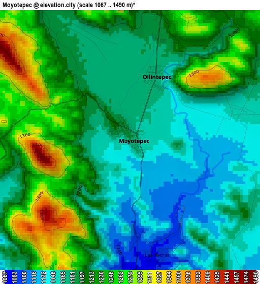
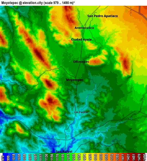
Below is the Elevation map of Moyotepec, which displays elevation range with different colors. Scale of the first map is from 1067 to 1490 m (3501 to 4888 ft) with average elevation of 1199.7 meters (=3936 ft) [note 1]
These maps also provides idea of topography and contour of this city, they are displayed at different zoom levels. More info about maps, scale and edge coordinates you can find below images.
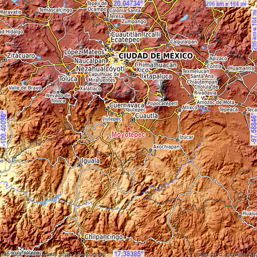
| \ | Map #1 | Map #2 | Topo.Map |
| Scale [m] | 1067..1490 m | 979..1490 m | × |
| Scale [ft] | 3501..4888 ft | 3212..4888 ft | × |
| Average | 1199.7 m = 3936 ft | 1197.2 m = 3928 ft | × |
| Width | 9.26 km = 5.8 mi | 18.51 km = 11.5 mi | 296.2 km = 184 mi |
| Height | 9.26 km = 5.8 mi | 18.51 km = 11.5 mi | 296.2 km = 184 mi |
| ↑Max Latitude | 18.762455° | 18.80406° | 20.04734° |
| Latitude at center | 18.72084° | 18.72084° | 18.72084° |
| ↓Min Latitude | 18.679215° | 18.637579° | 17.38385° |
| ← Min Longitude | -99.038655° | -99.082601° | -100.40096° |
| Longitude center | -98.99471° | -98.99471° | -98.99471° |
| →Max Longitude | -98.950765° | -98.906819° | -97.58846° |
Nearby cities:
Cities around Moyotepec sort by population:
• San Pedro Apatlaco elevation 1291 m
8.8 km,  24°
24°
• Anenecuilco 1267 m
6.3 km,  5°
5°
• Tenextepango 1158 m
4 km,  77°
77°
• Ciudad Ayala 1231 m
5.3 km, 14°
• San Juan Ahuehueyo 1170 m
6.6 km,  95°
95°
• Constancio Farfán (La Pascuala) 1213 m
4.9 km,  61°
61°
• Abelardo L. Rodríguez 1170 m
2.1 km,  28°
28°
• Olintepec 1176 m
2.3 km, 19°
• Unidad Habitacional 10 de Abril 1293 m
9.1 km,  65°
65°
• San Vicente de Juárez 1087 m
4.3 km,  166°
166°
• San Rafael Zaragoza 1047 m
8.9 km,  186°
186°
• El Salitre 1147 m
6.3 km,  142°
142°
Multilingual:
 En español:
Moyotepec elevación 1182 m.
 En France:
Moyotepec élévation 1182 m.
 Auf Deutsch:
Moyotepec höhe über dem Meeresspiegel ist 1182 m.

Sources and notes:
- [note 1] Map square and city borders are not equal. Map elevation data is calculated only from area inside that square.
- [src 1] Elevation data from geonames database provided with same terms of usage.
- [src 2] The elevation map of Moyotepec is generated using elevation data from NASA's 3 arcsec (90m) resolution SRTM data.
- [src 3] Base (background) map © OpenStreetMap contributors tiles are generated by Geofabrik and OpenTopoMap.
Copyright & License:
This Moyotepec Elevation Map is licensed under CC BY-SA. You may reuse any part from this page, if you give a proper credit by linking to this URL:
 More info on terms of use page.