San Vicente de Juárez elevation
San Vicente de Juárez (Morelos, Ayala), Mexico elevation is 1087 meters and San Vicente de Juárez elevation in feet is 3566 ft above sea level [src 1]. San Vicente de Juárez is a populated place (feature code) with elevation that is 227 meters (745 ft) smaller than average city elevation in Mexico.
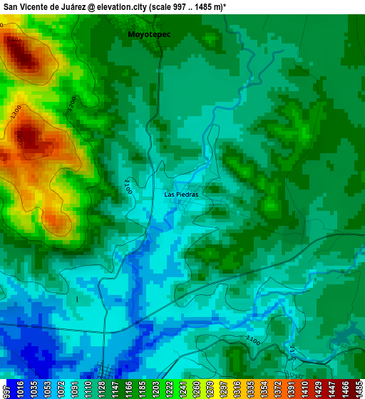
Below is the Elevation map of San Vicente de Juárez, which displays elevation range with different colors. Scale of the first map is from 997 to 1485 m (3271 to 4872 ft) with average elevation of 1143.2 meters (=3751 ft) [note 1]
These maps also provides idea of topography and contour of this city, they are displayed at different zoom levels. More info about maps, scale and edge coordinates you can find below images.
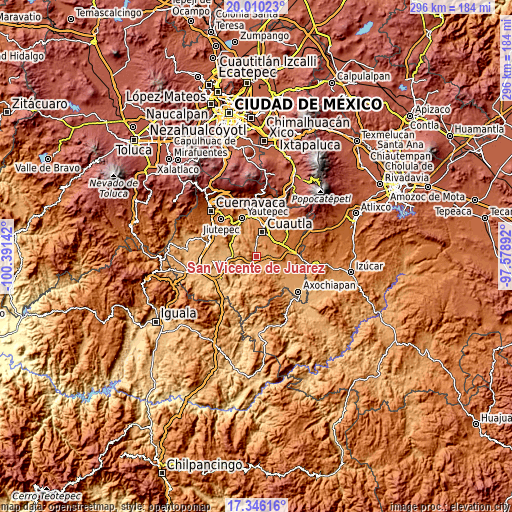
| \ | Map #1 | Topo.Map |
| Scale [m] | 997..1485 m | × |
| Scale [ft] | 3271..4872 ft | × |
| Average | 1143.2 m = 3751 ft | × |
| Width | 9.26 km = 5.8 mi | 296.2 km = 184 mi |
| Height | 9.26 km = 5.8 mi | 296.2 km = 184 mi |
| ↑Max Latitude | 18.725054° | 20.01023° |
| Latitude at center | 18.68343° | 18.68343° |
| ↓Min Latitude | 18.641795° | 17.34616° |
| ← Min Longitude | -99.029115° | -100.39142° |
| Longitude center | -98.98517° | -98.98517° |
| →Max Longitude | -98.941225° | -97.57892° |
Nearby cities:
Cities around San Vicente de Juárez sort by population:
• Tenextepango elevation 1158 m
5.8 km,  29°
29°
• Ciudad Ayala 1231 m
9.3 km,  1°
1°
• Moyotepec 1182 m
4.3 km,  346°
346°
• Chinameca 1055 m
6.9 km,  190°
190°
• San Juan Ahuehueyo 1170 m
6.5 km,  57°
57°
• Constancio Farfán (La Pascuala) 1213 m
7.3 km, 26°
• Abelardo L. Rodríguez 1170 m
6 km,  359°
359°
• Huitchila 1152 m
8 km,  128°
128°
• Olintepec 1176 m
6.4 km, 358°
• Zacapalco 1101 m
5.6 km,  151°
151°
• San Rafael Zaragoza 1047 m
5 km,  203°
203°
• El Salitre 1147 m
3 km,  106°
106°
Multilingual:
 En español:
San Vicente de Juárez elevación 1087 m.
 En France:
San Vicente de Juárez élévation 1087 m.
 Auf Deutsch:
San Vicente de Juárez höhe über dem Meeresspiegel ist 1087 m.
 На русском:
San Vicente de Juárez высота над уровнем моря 1087 м
Sources and notes:
- [note 1] Map square and city borders are not equal. Map elevation data is calculated only from area inside that square.
- [src 1] Elevation data from geonames database provided with same terms of usage.
- [src 2] The elevation map of San Vicente de Juárez is generated using elevation data from NASA's 3 arcsec (90m) resolution SRTM data.
- [src 3] Base (background) map © OpenStreetMap contributors tiles are generated by Geofabrik and OpenTopoMap.
Copyright & License:
This San Vicente de Juárez Elevation Map is licensed under CC BY-SA. You may reuse any part from this page, if you give a proper credit by linking to this URL:
 More info on terms of use page.