Ocotitlán elevation
Ocotitlán (Veracruz, Ixhuatlán del Café), Mexico elevation is 1190 meters and Ocotitlán elevation in feet is 3904 ft above sea level [src 1]. Ocotitlán is a populated place (feature code) with elevation that is 124 meters (407 ft) smaller than average city elevation in Mexico.
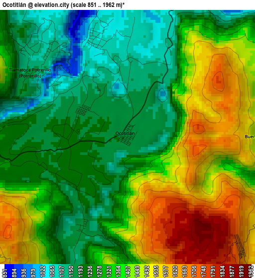
Below is the Elevation map of Ocotitlán, which displays elevation range with different colors. Scale of the first map is from 851 to 1962 m (2792 to 6437 ft) with average elevation of 1341.8 meters (=4402 ft) [note 1]
These maps also provides idea of topography and contour of this city, they are displayed at different zoom levels. More info about maps, scale and edge coordinates you can find below images.
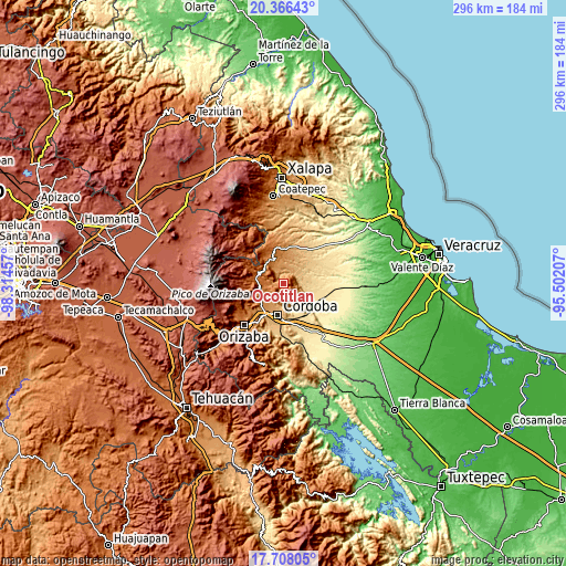
| \ | Map #1 | Topo.Map |
| Scale [m] | 851..1962 m | × |
| Scale [ft] | 2792..6437 ft | × |
| Average | 1341.8 m = 4402 ft | × |
| Width | 9.24 km = 5.7 mi | 295.6 km = 183.7 mi |
| Height | 9.24 km = 5.7 mi | 295.6 km = 183.7 mi |
| ↑Max Latitude | 19.084095° | 20.36643° |
| Latitude at center | 19.04256° | 19.04256° |
| ↓Min Latitude | 19.001014° | 17.70805° |
| ← Min Longitude | -96.952265° | -98.31457° |
| Longitude center | -96.90832° | -96.90832° |
| →Max Longitude | -96.864375° | -95.50207° |
Nearby cities:
Cities around Ocotitlán sort by population:
• Ixhuatlán del Café elevation 1355 m
8 km,  276°
276°
• Presidio 1330 m
7.3 km,  293°
293°
• San José Tenejapa 1117 m
7.5 km,  113°
113°
• Tlamatoca 1051 m
6.4 km,  332°
332°
• Ixpila 1133 m
10.4 km,  323°
323°
• La Palma 751 m
8.5 km,  87°
87°
• Tepatlaxco 833 m
7.3 km,  66°
66°
• Ixcatla 1067 m
3.8 km,  343°
343°
• Tecama 1192 m
9.2 km,  241°
241°
• Buena Vista 1238 m
5.4 km, 89°
• Ixcapantla 1354 m
6.8 km,  254°
254°
• Colonia Manuel González 946 m
9.6 km,  32°
32°
Multilingual:
 En español:
Ocotitlán elevación 1190 m.
 En France:
Ocotitlán élévation 1190 m.
 Auf Deutsch:
Ocotitlán höhe über dem Meeresspiegel ist 1190 m.

Sources and notes:
- [note 1] Map square and city borders are not equal. Map elevation data is calculated only from area inside that square.
- [src 1] Elevation data from geonames database provided with same terms of usage.
- [src 2] The elevation map of Ocotitlán is generated using elevation data from NASA's 3 arcsec (90m) resolution SRTM data.
- [src 3] Base (background) map © OpenStreetMap contributors tiles are generated by Geofabrik and OpenTopoMap.
Copyright & License:
This Ocotitlán Elevation Map is licensed under CC BY-SA. You may reuse any part from this page, if you give a proper credit by linking to this URL:
 More info on terms of use page.