Ostuacán elevation
Ostuacán (Chiapas), Mexico elevation is 132 meters and Ostuacán elevation in feet is 433 ft above sea level [src 1]. Ostuacán is a seat of a second-order administrative division (feature code) with elevation that is 1182 meters (3878 ft) smaller than average city elevation in Mexico.
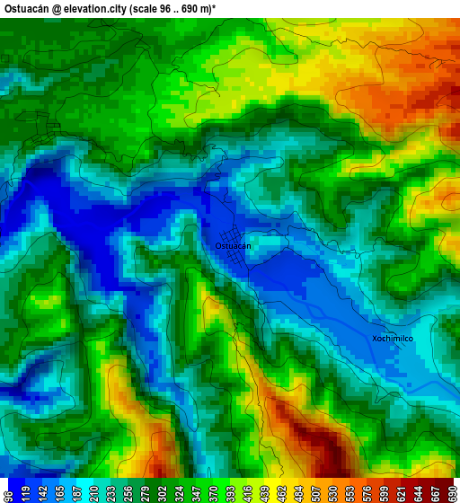
Below is the Elevation map of Ostuacán, which displays elevation range with different colors. Scale of the first map is from 96 to 690 m (315 to 2264 ft) with average elevation of 302.9 meters (=994 ft) [note 1]
These maps also provides idea of topography and contour of this city, they are displayed at different zoom levels. More info about maps, scale and edge coordinates you can find below images.
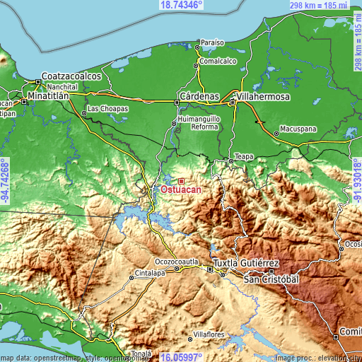
| \ | Map #1 | Topo.Map |
| Scale [m] | 96..690 m | × |
| Scale [ft] | 315..2264 ft | × |
| Average | 302.9 m = 994 ft | × |
| Width | 9.32 km = 5.8 mi | 298.4 km = 185.4 mi |
| Height | 9.33 km = 5.8 mi | 298.4 km = 185.4 mi |
| ↑Max Latitude | 17.448568° | 18.74346° |
| Latitude at center | 17.40664° | 17.40664° |
| ↓Min Latitude | 17.364702° | 16.05997° |
| ← Min Longitude | -93.380375° | -94.74268° |
| Longitude center | -93.33643° | -93.33643° |
| →Max Longitude | -93.292485° | -91.93018° |
Nearby cities:
Cities around Ostuacán sort by population:
• Pichucalco elevation 44 m
26.1 km,  63°
63°
• Juárez 131 m
26.8 km,  34°
34°
• Ixtacomitán 154 m
25.5 km,  83°
83°
• Chapultenango 637 m
23.1 km,  108°
108°
• Nuevo Juan del Grijalva 286 m
4.4 km,  301°
301°
• Plan de Ayala 60 m
17.7 km,  294°
294°
• Francisco I. Madero 290 m
22.3 km,  194°
194°
• Nuevo Xochimilco 270 m
6.3 km,  326°
326°
• Adolfo López Mateos 577 m
26 km,  215°
215°
• El Triunfo 1ra. Sección (Cardona) 83 m
24.9 km, 26°
• San Miguel la Sardina 495 m
12.6 km, 187°
• Sunuapa 105 m
13.6 km,  46°
46°
Multilingual:
 En español:
Ostuacán elevación 132 m.
 En France:
Ostuacán élévation 132 m.
 Auf Deutsch:
Ostuacán höhe über dem Meeresspiegel ist 132 m.

Sources and notes:
- [note 1] Map square and city borders are not equal. Map elevation data is calculated only from area inside that square.
- [src 1] Elevation data from geonames database provided with same terms of usage.
- [src 2] The elevation map of Ostuacán is generated using elevation data from NASA's 3 arcsec (90m) resolution SRTM data.
- [src 3] Base (background) map © OpenStreetMap contributors tiles are generated by Geofabrik and OpenTopoMap.
Copyright & License:
This Ostuacán Elevation Map is licensed under CC BY-SA. You may reuse any part from this page, if you give a proper credit by linking to this URL:
 More info on terms of use page.