Pajapan elevation
Pajapan (Veracruz), Mexico elevation is 198 meters and Pajapan elevation in feet is 650 ft above sea level [src 1]. Pajapan is a seat of a second-order administrative division (feature code) with elevation that is 1116 meters (3661 ft) smaller than average city elevation in Mexico.
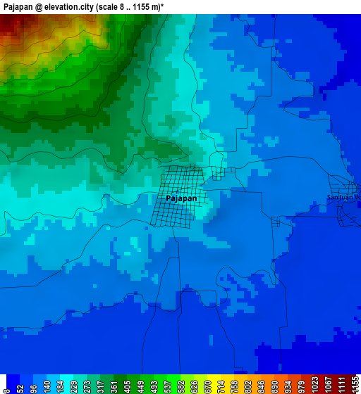
Below is the Elevation map of Pajapan, which displays elevation range with different colors. Scale of the first map is from 8 to 1155 m (26 to 3789 ft) with average elevation of 186.8 meters (=613 ft) [note 1]
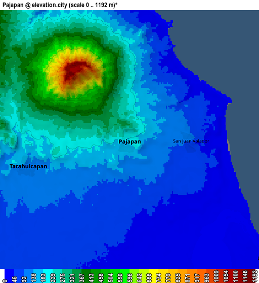
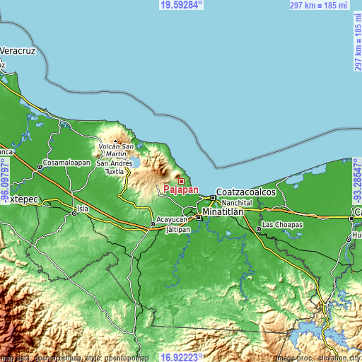
These maps also provides idea of topography and contour of this city, they are displayed at different zoom levels. More info about maps, scale and edge coordinates you can find below images.
| \ | Map #1 | Map #2 | Topo.Map |
| Scale [m] | 8..1155 m | 0..1192 m | × |
| Scale [ft] | 26..3789 ft | 0..3911 ft | × |
| Average | 186.8 m = 613 ft | 166.4 m = 546 ft | × |
| Width | 9.28 km = 5.8 mi | 18.56 km = 11.5 mi | 296.9 km = 184.5 mi |
| Height | 9.28 km = 5.8 mi | 18.56 km = 11.5 mi | 297 km = 184.5 mi |
| ↑Max Latitude | 18.304397° | 18.346113° | 19.59284° |
| Latitude at center | 18.26267° | 18.26267° | 18.26267° |
| ↓Min Latitude | 18.220933° | 18.179186° | 16.92223° |
| ← Min Longitude | -94.735665° | -94.779611° | -96.09797° |
| Longitude center | -94.69172° | -94.69172° | -94.69172° |
| →Max Longitude | -94.647775° | -94.603829° | -93.28547° |
Nearby cities:
Cities around Pajapan sort by population:
• Fraccionamiento Ciudad Olmeca elevation 19 m
19.3 km,  130°
130°
• Tatahuicapan 120 m
7.6 km,  256°
256°
• Mecayapan 347 m
16.2 km,  252°
252°
• Soteapan 450 m
19.4 km, 260°
• Huazuntlán 73 m
15.9 km,  222°
222°
• Chacalapa 26 m
20.5 km,  183°
183°
• Ixhuapán 84 m
14.9 km,  229°
229°
• Minzapan 37 m
14.3 km,  195°
195°
• San Juan Volador 104 m
4.2 km,  88°
88°
• San Fernando 675 m
20.4 km,  271°
271°
• Ocotal Chico 608 m
17.8 km, 268°
• Las Barrillas 9 m
13.3 km, 129°
Multilingual:
 En español:
Pajapan elevación 198 m.
 En France:
Pajapan élévation 198 m.


Sources and notes:
- [note 1] Map square and city borders are not equal. Map elevation data is calculated only from area inside that square.
- [src 1] Elevation data from geonames database provided with same terms of usage.
- [src 2] The elevation map of Pajapan is generated using elevation data from NASA's 3 arcsec (90m) resolution SRTM data.
- [src 3] Base (background) map © OpenStreetMap contributors tiles are generated by Geofabrik and OpenTopoMap.
Copyright & License:
This Pajapan Elevation Map is licensed under CC BY-SA. You may reuse any part from this page, if you give a proper credit by linking to this URL:
 More info on terms of use page.