Pánuco elevation
Pánuco (Veracruz), Mexico elevation is 16 meters and Pánuco elevation in feet is 52 ft above sea level [src 1]. Pánuco is a seat of a second-order administrative division (feature code) with elevation that is 1298 meters (4259 ft) smaller than average city elevation in Mexico.
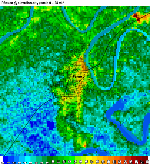
Below is the Elevation map of Pánuco, which displays elevation range with different colors. Scale of the first map is from 0 to 28 m (0 to 92 ft) with average elevation of 8.1 meters (=27 ft) [note 1]
These maps also provides idea of topography and contour of this city, they are displayed at different zoom levels. More info about maps, scale and edge coordinates you can find below images.
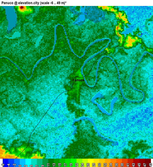
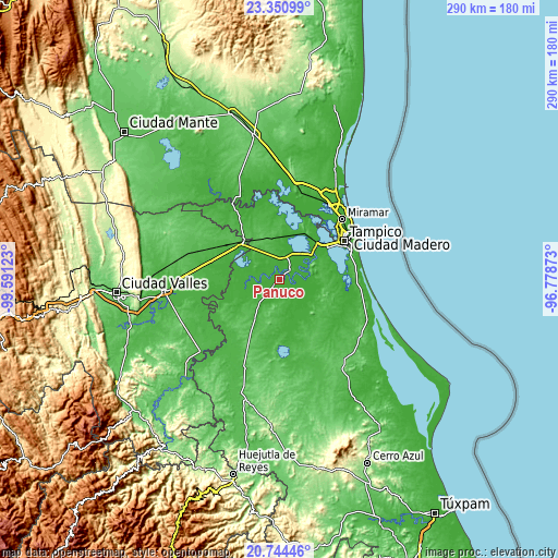
| \ | Map #1 | Map #2 | Topo.Map |
| Scale [m] | 0..28 m | -6..49 m | × |
| Scale [ft] | 0..92 ft | -20..161 ft | × |
| Average | 8.1 m = 27 ft | 8.1 m = 27 ft | × |
| Width | 9.06 km = 5.6 mi | 18.12 km = 11.3 mi | 289.8 km = 180.1 mi |
| Height | 9.06 km = 5.6 mi | 18.11 km = 11.3 mi | 289.8 km = 180.1 mi |
| ↑Max Latitude | 22.094454° | 22.135166° | 23.35099° |
| Latitude at center | 22.05373° | 22.05373° | 22.05373° |
| ↓Min Latitude | 22.012994° | 21.972247° | 20.74446° |
| ← Min Longitude | -98.228925° | -98.272871° | -99.59123° |
| Longitude center | -98.18498° | -98.18498° | -98.18498° |
| →Max Longitude | -98.141035° | -98.097089° | -96.77873° |
Nearby cities:
Cities around Pánuco sort by population:
• Ébano elevation 62 m
26.9 km,  312°
312°
• Benito Juárez 4 m
39 km,  65°
65°
• Anahuac 8 m
37.8 km,  64°
64°
• Moralillo 7 m
34 km, 55°
• Ciudad Cuauhtémoc 9 m
38.9 km, 68°
• Perseverancia 14 m
26.8 km,  46°
46°
• Pujal-Coy 34 m
35.7 km,  292°
292°
• Oviedo 20 m
22.2 km,  267°
267°
• Plan de Iguala 21 m
28.9 km, 266°
• Antonio J Bermúdez 35 m
11.1 km,  14°
14°
• Aquiles Serdán 17 m
20.6 km,  169°
169°
• El Molino 27 m
19.3 km,  217°
217°
Multilingual:
 En español:
Pánuco elevación 16 m.
 En France:
Pánuco élévation 16 m.


Sources and notes:
- [note 1] Map square and city borders are not equal. Map elevation data is calculated only from area inside that square.
- [src 1] Elevation data from geonames database provided with same terms of usage.
- [src 2] The elevation map of Pánuco is generated using elevation data from NASA's 3 arcsec (90m) resolution SRTM data.
- [src 3] Base (background) map © OpenStreetMap contributors tiles are generated by Geofabrik and OpenTopoMap.
Copyright & License:
This Pánuco Elevation Map is licensed under CC BY-SA. You may reuse any part from this page, if you give a proper credit by linking to this URL:
 More info on terms of use page.