Benito Juárez elevation
Benito Juárez (Veracruz, Pueblo Viejo), Mexico elevation is 4 meters and Benito Juárez elevation in feet is 13 ft above sea level [src 1]. Benito Juárez is a populated place (feature code) with elevation that is 1310 meters (4298 ft) smaller than average city elevation in Mexico.
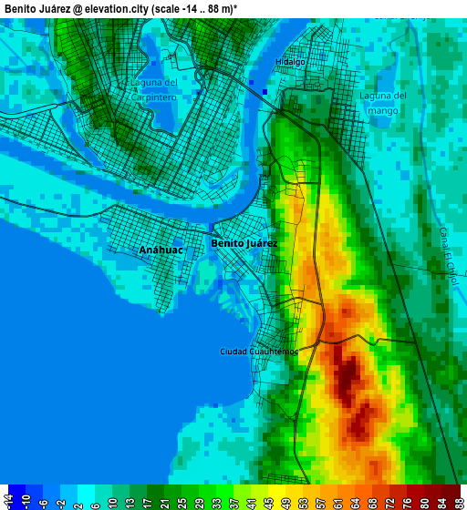
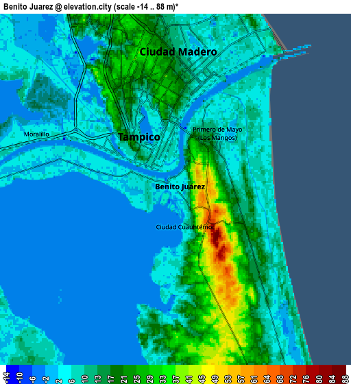
Below is the Elevation map of Benito Juárez, which displays elevation range with different colors. Scale of the first map is from -14 to 88 m (-46 to 289 ft) with average elevation of 12.5 meters (=41 ft) [note 1]
These maps also provides idea of topography and contour of this city, they are displayed at different zoom levels. More info about maps, scale and edge coordinates you can find below images.
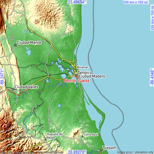
| \ | Map #1 | Map #2 | Topo.Map |
| Scale [m] | -14..88 m | -14..88 m | × |
| Scale [ft] | -46..289 ft | -46..289 ft | × |
| Average | 12.5 m = 41 ft | 10.1 m = 33 ft | × |
| Width | 9.05 km = 5.6 mi | 18.1 km = 11.2 mi | 289.5 km = 179.9 mi |
| Height | 9.05 km = 5.6 mi | 18.1 km = 11.2 mi | 289.5 km = 179.9 mi |
| ↑Max Latitude | 22.241352° | 22.282021° | 23.49654° |
| Latitude at center | 22.20067° | 22.20067° | 22.20067° |
| ↓Min Latitude | 22.159977° | 22.119271° | 20.89273° |
| ← Min Longitude | -97.884795° | -97.928741° | -99.2471° |
| Longitude center | -97.84085° | -97.84085° | -97.84085° |
| →Max Longitude | -97.796905° | -97.752959° | -96.4346° |
Nearby cities:
Cities around Benito Juárez sort by population:
• Tampico elevation 21 m
10.1 km,  337°
337°
• Ciudad Madero 8 m
8 km,  3°
3°
• Miramar 8 m
18.8 km, 341°
• Altamira 14 m
23.5 km,  334°
334°
• Anahuac 8 m
1.5 km,  278°
278°
• Moralillo 7 m
7.8 km,  290°
290°
• Ciudad Cuauhtémoc 9 m
1.9 km,  160°
160°
• Primero de Mayo 5 m
3.5 km,  38°
38°
• Perseverancia 14 m
16.1 km, 277°
• Tampico Alto 32 m
10.6 km, 157°
• Carrillo Puerto 15 m
28.6 km, 333°
• La Pedrera 13 m
21.9 km,  348°
348°
Multilingual:
 En español:
Benito Juárez elevación 4 m.
 En France:
Benito Juárez élévation 4 m.
 Auf Deutsch:
Benito Juárez höhe über dem Meeresspiegel ist 4 m.

Sources and notes:
- [note 1] Map square and city borders are not equal. Map elevation data is calculated only from area inside that square.
- [src 1] Elevation data from geonames database provided with same terms of usage.
- [src 2] The elevation map of Benito Juárez is generated using elevation data from NASA's 3 arcsec (90m) resolution SRTM data.
- [src 3] Base (background) map © OpenStreetMap contributors tiles are generated by Geofabrik and OpenTopoMap.
Copyright & License:
This Benito Juárez Elevation Map is licensed under CC BY-SA. You may reuse any part from this page, if you give a proper credit by linking to this URL:
 More info on terms of use page.