Paso de Ovejas elevation
Paso de Ovejas (Veracruz), Mexico elevation is 57 meters and Paso de Ovejas elevation in feet is 187 ft above sea level [src 1]. Paso de Ovejas is a seat of a second-order administrative division (feature code) with elevation that is 1257 meters (4124 ft) smaller than average city elevation in Mexico.
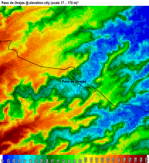
Below is the Elevation map of Paso de Ovejas, which displays elevation range with different colors. Scale of the first map is from 17 to 170 m (56 to 558 ft) with average elevation of 84.2 meters (=276 ft) [note 1]
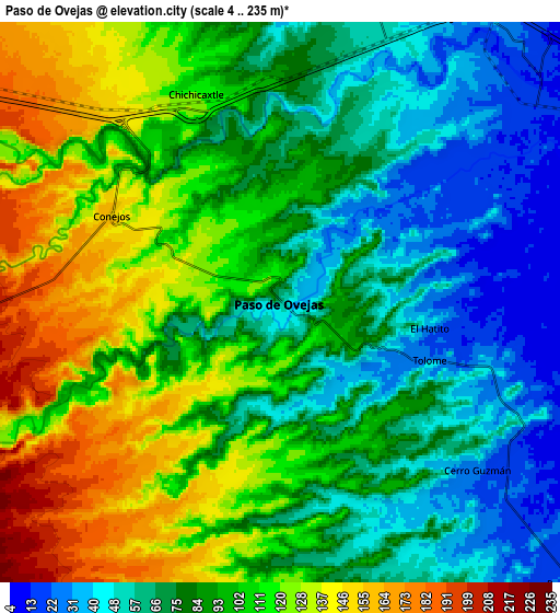
These maps also provides idea of topography and contour of this city, they are displayed at different zoom levels. More info about maps, scale and edge coordinates you can find below images.
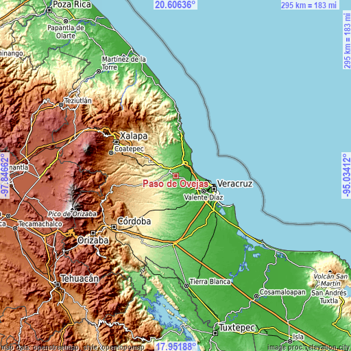
| \ | Map #1 | Map #2 | Topo.Map |
| Scale [m] | 17..170 m | 4..235 m | × |
| Scale [ft] | 56..558 ft | 13..771 ft | × |
| Average | 84.2 m = 276 ft | 91.4 m = 300 ft | × |
| Width | 9.22 km = 5.7 mi | 18.45 km = 11.5 mi | 295.2 km = 183.4 mi |
| Height | 9.22 km = 5.7 mi | 18.45 km = 11.5 mi | 295.2 km = 183.4 mi |
| ↑Max Latitude | 19.325974° | 19.367438° | 20.60636° |
| Latitude at center | 19.2845° | 19.2845° | 19.2845° |
| ↓Min Latitude | 19.243015° | 19.20152° | 17.95188° |
| ← Min Longitude | -96.484315° | -96.528261° | -97.84662° |
| Longitude center | -96.44037° | -96.44037° | -96.44037° |
| →Max Longitude | -96.396425° | -96.352479° | -95.03412° |
Nearby cities:
Cities around Paso de Ovejas sort by population:
• José Cardel elevation 24 m
11.9 km,  38°
38°
• Rinconada 265 m
15.3 km,  300°
300°
• Cabezas 29 m
11.4 km,  31°
31°
• Tolome 28 m
5.2 km,  112°
112°
• Vargas 23 m
14.1 km,  116°
116°
• Puente Jula 22 m
13.5 km,  134°
134°
• Chichicaxtle 125 m
7.2 km,  335°
335°
• Cerro Guzmán 28 m
8.5 km, 130°
• El Hatito 37 m
5 km,  99°
99°
• Tierra Colorada 18 m
9.9 km, 131°
• Nicolás Blanco (San Pancho) 14 m
13.1 km,  54°
54°
• El Palmar 34 m
11.6 km,  5°
5°
Multilingual:
 En español:
Paso de Ovejas elevación 57 m.
 En France:
Paso de Ovejas élévation 57 m.
 Auf Deutsch:
Paso de Ovejas höhe über dem Meeresspiegel ist 57 m.

Sources and notes:
- [note 1] Map square and city borders are not equal. Map elevation data is calculated only from area inside that square.
- [src 1] Elevation data from geonames database provided with same terms of usage.
- [src 2] The elevation map of Paso de Ovejas is generated using elevation data from NASA's 3 arcsec (90m) resolution SRTM data.
- [src 3] Base (background) map © OpenStreetMap contributors tiles are generated by Geofabrik and OpenTopoMap.
Copyright & License:
This Paso de Ovejas Elevation Map is licensed under CC BY-SA. You may reuse any part from this page, if you give a proper credit by linking to this URL:
 More info on terms of use page.