Vargas elevation
Vargas (Veracruz), Mexico elevation is 23 meters and Vargas elevation in feet is 75 ft above sea level [src 1]. Vargas is a populated place (feature code) with elevation that is 1291 meters (4236 ft) smaller than average city elevation in Mexico.
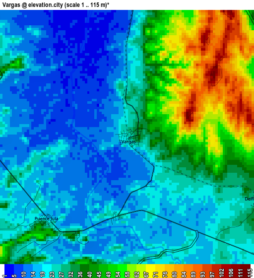
Below is the Elevation map of Vargas, which displays elevation range with different colors. Scale of the first map is from 1 to 115 m (3 to 377 ft) with average elevation of 30.3 meters (=99 ft) [note 1]
These maps also provides idea of topography and contour of this city, they are displayed at different zoom levels. More info about maps, scale and edge coordinates you can find below images.
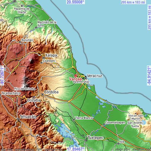
| \ | Map #1 | Topo.Map |
| Scale [m] | 1..115 m | × |
| Scale [ft] | 3..377 ft | × |
| Average | 30.3 m = 99 ft | × |
| Width | 9.23 km = 5.7 mi | 295.3 km = 183.5 mi |
| Height | 9.23 km = 5.7 mi | 295.3 km = 183.5 mi |
| ↑Max Latitude | 19.269229° | 20.55008° |
| Latitude at center | 19.22774° | 19.22774° |
| ↓Min Latitude | 19.186241° | 17.89467° |
| ← Min Longitude | -96.364405° | -97.72671° |
| Longitude center | -96.32046° | -96.32046° |
| →Max Longitude | -96.276515° | -94.91421° |
Nearby cities:
Cities around Vargas sort by population:
• Fraccionamiento Geovillas los Pinos elevation 19 m
9.9 km,  96°
96°
• Delfino Victoria (Santa Fe) 36 m
5.4 km,  114°
114°
• Oasis 41 m
11 km, 105°
• Tolome 28 m
8.9 km,  299°
299°
• Puente Jula 22 m
4.2 km,  223°
223°
• Colonia el Renacimiento 26 m
11 km, 95°
• Mata Loma 46 m
11 km,  166°
166°
• San Julián 26 m
6.5 km,  59°
59°
• Cerro Guzmán 28 m
6.2 km,  277°
277°
• El Hatito 37 m
9.5 km,  305°
305°
• Tierra Colorada 18 m
5.1 km,  267°
267°
• Santa Rita 47 m
9.2 km,  136°
136°
Multilingual:
 En español:
Vargas elevación 23 m.
 En France:
Vargas élévation 23 m.


Sources and notes:
- [note 1] Map square and city borders are not equal. Map elevation data is calculated only from area inside that square.
- [src 1] Elevation data from geonames database provided with same terms of usage.
- [src 2] The elevation map of Vargas is generated using elevation data from NASA's 3 arcsec (90m) resolution SRTM data.
- [src 3] Base (background) map © OpenStreetMap contributors tiles are generated by Geofabrik and OpenTopoMap.
Copyright & License:
This Vargas Elevation Map is licensed under CC BY-SA. You may reuse any part from this page, if you give a proper credit by linking to this URL:
 More info on terms of use page.