Sabancuy elevation
Sabancuy (Campeche, Carmen), Mexico elevation is 2 meters and Sabancuy elevation in feet is 7 ft above sea level [src 1]. Sabancuy is a populated place (feature code) with elevation that is 1312 meters (4304 ft) smaller than average city elevation in Mexico.
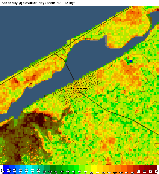
Below is the Elevation map of Sabancuy, which displays elevation range with different colors. Scale of the first map is from -17 to 13 m (-56 to 43 ft) with average elevation of 1.2 meters (=4 ft) [note 1]
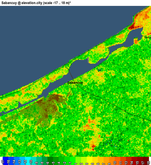
These maps also provides idea of topography and contour of this city, they are displayed at different zoom levels. More info about maps, scale and edge coordinates you can find below images.
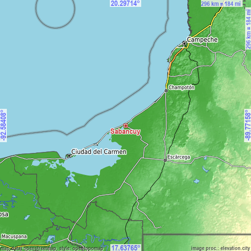
| \ | Map #1 | Map #2 | Topo.Map |
| Scale [m] | -17..13 m | -17..18 m | × |
| Scale [ft] | -56..43 ft | -56..59 ft | × |
| Average | 1.2 m = 4 ft | 0.7 m = 2 ft | × |
| Width | 9.24 km = 5.7 mi | 18.48 km = 11.5 mi | 295.7 km = 183.7 mi |
| Height | 9.24 km = 5.7 mi | 18.48 km = 11.5 mi | 295.7 km = 183.7 mi |
| ↑Max Latitude | 19.014253° | 19.055795° | 20.29714° |
| Latitude at center | 18.9727° | 18.9727° | 18.9727° |
| ↓Min Latitude | 18.931137° | 18.889563° | 17.63765° |
| ← Min Longitude | -91.221775° | -91.265721° | -92.58408° |
| Longitude center | -91.17783° | -91.17783° | -91.17783° |
| →Max Longitude | -91.133885° | -91.089939° | -89.77158° |
Nearby cities:
Cities around Sabancuy sort by population:
• Champotón elevation 3 m
63.6 km,  49°
49°
• Escárcega 83 m
60.9 km,  131°
131°
• Isla Aguada 2 m
39 km,  238°
238°
• División del Norte 101 m
65.8 km,  138°
138°
• Carrillo Puerto 64 m
70.2 km,  78°
78°
• Chicbul 20 m
34.5 km, 129°
• Xbacab 21 m
48.1 km,  94°
94°
• San Pablo Pixtún 8 m
50.2 km,  69°
69°
• Matamoros 108 m
70.7 km, 127°
• Mamantel 20 m
50.6 km,  169°
169°
• Licenciado Gustavo Díaz Ordaz (18 de Marzo) 17 m
42.1 km,  154°
154°
• Abelardo L. Rodríguez 27 m
39.6 km, 133°
Multilingual:
 En español:
Sabancuy elevación 2 m.
 En France:
Sabancuy élévation 2 m.


Sources and notes:
- [note 1] Map square and city borders are not equal. Map elevation data is calculated only from area inside that square.
- [src 1] Elevation data from geonames database provided with same terms of usage.
- [src 2] The elevation map of Sabancuy is generated using elevation data from NASA's 3 arcsec (90m) resolution SRTM data.
- [src 3] Base (background) map © OpenStreetMap contributors tiles are generated by Geofabrik and OpenTopoMap.
Copyright & License:
This Sabancuy Elevation Map is licensed under CC BY-SA. You may reuse any part from this page, if you give a proper credit by linking to this URL:
 More info on terms of use page.