Champotón elevation
Champotón (Campeche), Mexico elevation is 3 meters and Champotón elevation in feet is 10 ft above sea level [src 1]. Champotón is a seat of a second-order administrative division (feature code) with elevation that is 1311 meters (4301 ft) smaller than average city elevation in Mexico.
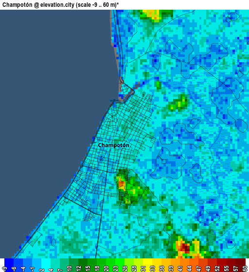
Below is the Elevation map of Champotón, which displays elevation range with different colors. Scale of the first map is from -9 to 60 m (-30 to 197 ft) with average elevation of 3.4 meters (=11 ft) [note 1]
These maps also provides idea of topography and contour of this city, they are displayed at different zoom levels. More info about maps, scale and edge coordinates you can find below images.
| \ | Map #1 | Map #2 | Topo.Map |
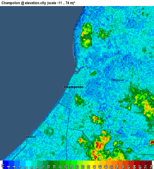
| Scale [m] | -9..60 m | -11..74 m | × |
| Scale [ft] | -30..197 ft | -36..243 ft | × |
| Average | 3.4 m = 11 ft | 6.4 m = 21 ft | × |
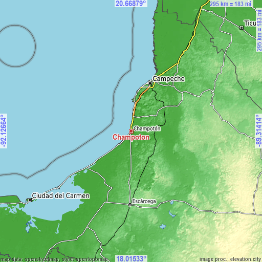
| Width | 9.22 km = 5.7 mi | 18.44 km = 11.5 mi | 295 km = 183.3 mi |
| Height | 9.22 km = 5.7 mi | 18.44 km = 11.5 mi | 295.1 km = 183.4 mi |
| ↑Max Latitude | 19.388908° | 19.430356° | 20.66879° |
| Latitude at center | 19.34745° | 19.34745° | 19.34745° |
| ↓Min Latitude | 19.305981° | 19.264502° | 18.01533° |
| ← Min Longitude | -90.764335° | -90.808281° | -92.12664° |
| Longitude center | -90.72039° | -90.72039° | -90.72039° |
| →Max Longitude | -90.676445° | -90.632499° | -89.31414° |
Nearby cities:
Cities around Champotón sort by population:
• Seybaplaya elevation 7 m
32.7 km,  6°
6°
• Lerma 8 m
52.3 km, 13°
• Chiná 15 m
52.5 km,  26°
26°
• Villa Madero 0 m
20.2 km, 6°
• Santo Domingo Kesté 25 m
27.7 km,  52°
52°
• Carrillo Puerto 64 m
35 km,  143°
143°
• Sihochac 7 m
22.2 km,  39°
39°
• Xbacab 21 m
45.1 km,  180°
180°
• San Pablo Pixtún 8 m
23.8 km, 182°
• Maya Tecún I 70 m
31.2 km,  133°
133°
• Hool 43 m
34.1 km,  57°
57°
• La Joya 4 m
15.6 km,  18°
18°
Multilingual:
 En español:
Champotón elevación 3 m.
 En France:
Champotón élévation 3 m.


Sources and notes:
- [note 1] Map square and city borders are not equal. Map elevation data is calculated only from area inside that square.
- [src 1] Elevation data from geonames database provided with same terms of usage.
- [src 2] The elevation map of Champotón is generated using elevation data from NASA's 3 arcsec (90m) resolution SRTM data.
- [src 3] Base (background) map © OpenStreetMap contributors tiles are generated by Geofabrik and OpenTopoMap.
Copyright & License:
This Champotón Elevation Map is licensed under CC BY-SA. You may reuse any part from this page, if you give a proper credit by linking to this URL:
 More info on terms of use page.