San Agustín Etla elevation
San Agustín Etla (Oaxaca, Villa de Etla), Mexico elevation is 1717 meters and San Agustín Etla elevation in feet is 5633 ft above sea level [src 1]. San Agustín Etla is a populated place (feature code) with elevation that is 403 meters (1322 ft) bigger than average city elevation in Mexico.
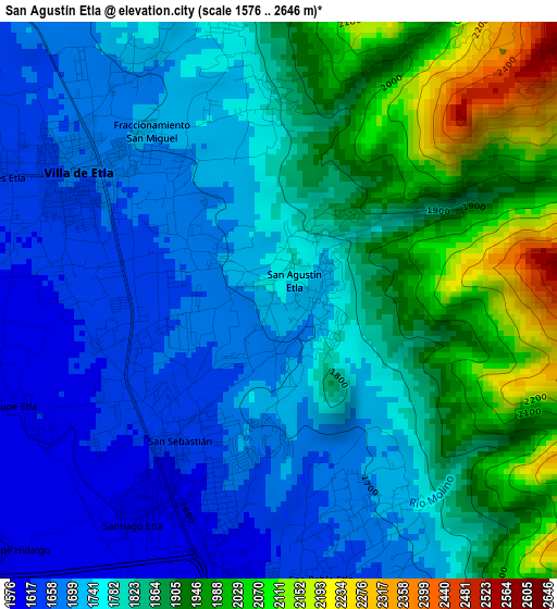
Below is the Elevation map of San Agustín Etla, which displays elevation range with different colors. Scale of the first map is from 1576 to 2646 m (5171 to 8681 ft) with average elevation of 1807.1 meters (=5929 ft) [note 1]
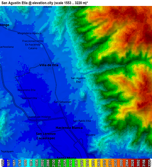
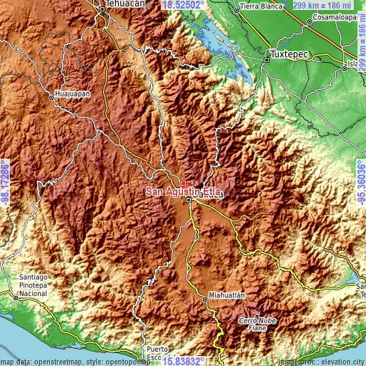
These maps also provides idea of topography and contour of this city, they are displayed at different zoom levels. More info about maps, scale and edge coordinates you can find below images.
| \ | Map #1 | Map #2 | Topo.Map |
| Scale [m] | 1576..2646 m | 1553..3220 m | × |
| Scale [ft] | 5171..8681 ft | 5095..10564 ft | × |
| Average | 1807.1 m = 5929 ft | 1969.4 m = 6461 ft | × |
| Width | 9.34 km = 5.8 mi | 18.67 km = 11.6 mi | 298.7 km = 185.6 mi |
| Height | 9.34 km = 5.8 mi | 18.67 km = 11.6 mi | 298.8 km = 185.7 mi |
| ↑Max Latitude | 17.228518° | 17.270487° | 18.52502° |
| Latitude at center | 17.18654° | 17.18654° | 17.18654° |
| ↓Min Latitude | 17.144552° | 17.102555° | 15.83832° |
| ← Min Longitude | -96.810555° | -96.854501° | -98.17286° |
| Longitude center | -96.76661° | -96.76661° | -96.76661° |
| →Max Longitude | -96.722665° | -96.678719° | -95.36036° |
Nearby cities:
Cities around San Agustín Etla sort by population:
• Hacienda Blanca elevation 1592 m
5.3 km,  190°
190°
• San Lorenzo Cacaotepec 1611 m
7.6 km,  210°
210°
• Villa de Etla 1666 m
4.1 km,  302°
302°
• Trinidad de Viguera 1625 m
6.5 km,  164°
164°
• Santiago Etla 1594 m
4.5 km, 212°
• San Pablo Etla 1677 m
5.1 km, 157°
• Fraccionamiento Ex-Hacienda Catano 1651 m
6.9 km,  311°
311°
• San Sebastián Etla 1630 m
3 km,  215°
215°
• Reyes Etla 1623 m
5.7 km,  287°
287°
• Fraccionamiento San Miguel 1714 m
3.6 km,  323°
323°
• Guadalupe Etla 1606 m
4.9 km,  251°
251°
• Guadalupe Hidalgo 1603 m
6.3 km,  228°
228°
Multilingual:
 En español:
San Agustín Etla elevación 1717 m.
 En France:
San Agustín Etla élévation 1717 m.
 Auf Deutsch:
San Agustín Etla höhe über dem Meeresspiegel ist 1717 m.

Sources and notes:
- [note 1] Map square and city borders are not equal. Map elevation data is calculated only from area inside that square.
- [src 1] Elevation data from geonames database provided with same terms of usage.
- [src 2] The elevation map of San Agustín Etla is generated using elevation data from NASA's 3 arcsec (90m) resolution SRTM data.
- [src 3] Base (background) map © OpenStreetMap contributors tiles are generated by Geofabrik and OpenTopoMap.
Copyright & License:
This San Agustín Etla Elevation Map is licensed under CC BY-SA. You may reuse any part from this page, if you give a proper credit by linking to this URL:
 More info on terms of use page.