San Pablo Etla elevation
San Pablo Etla (Oaxaca), Mexico elevation is 1677 meters and San Pablo Etla elevation in feet is 5502 ft above sea level [src 1]. San Pablo Etla is a populated place (feature code) with elevation that is 363 meters (1191 ft) bigger than average city elevation in Mexico.
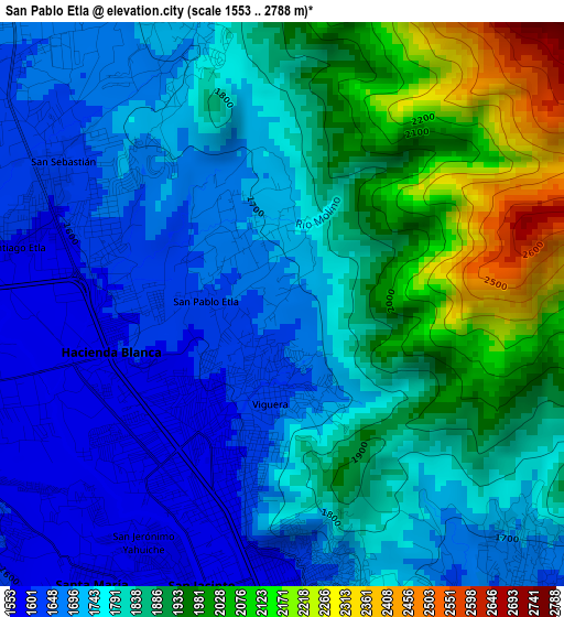
Below is the Elevation map of San Pablo Etla, which displays elevation range with different colors. Scale of the first map is from 1553 to 2788 m (5095 to 9147 ft) with average elevation of 1811.3 meters (=5943 ft) [note 1]
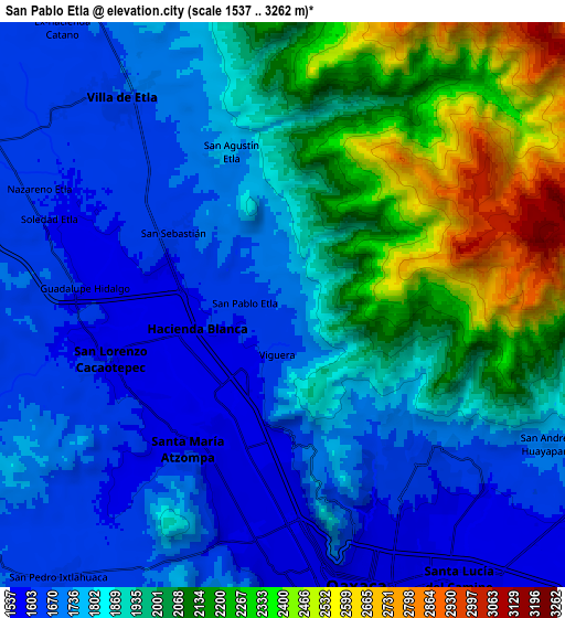
These maps also provides idea of topography and contour of this city, they are displayed at different zoom levels. More info about maps, scale and edge coordinates you can find below images.
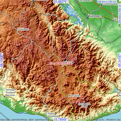
| \ | Map #1 | Map #2 | Topo.Map |
| Scale [m] | 1553..2788 m | 1537..3262 m | × |
| Scale [ft] | 5095..9147 ft | 5043..10702 ft | × |
| Average | 1811.3 m = 5943 ft | 1888 m = 6194 ft | × |
| Width | 9.34 km = 5.8 mi | 18.68 km = 11.6 mi | 298.8 km = 185.7 mi |
| Height | 9.34 km = 5.8 mi | 18.68 km = 11.6 mi | 298.8 km = 185.7 mi |
| ↑Max Latitude | 17.185958° | 17.227936° | 18.48276° |
| Latitude at center | 17.14397° | 17.14397° | 17.14397° |
| ↓Min Latitude | 17.101973° | 17.059966° | 15.79546° |
| ← Min Longitude | -96.792065° | -96.836011° | -98.15437° |
| Longitude center | -96.74812° | -96.74812° | -96.74812° |
| →Max Longitude | -96.704175° | -96.660229° | -95.34187° |
Nearby cities:
Cities around San Pablo Etla sort by population:
• Santa María Atzompa elevation 1597 m
5.6 km,  212°
212°
• San Jacinto Amilpas 1562 m
4.9 km,  197°
197°
• Hacienda Blanca 1592 m
3 km,  261°
261°
• San Lorenzo Cacaotepec 1611 m
6 km,  252°
252°
• Trinidad de Viguera 1625 m
1.5 km,  188°
188°
• Santiago Etla 1594 m
4.5 km,  282°
282°
• San Agustín Etla 1717 m
5.1 km,  337°
337°
• San Sebastián Etla 1630 m
4.4 km,  301°
301°
• Guadalupe Etla 1606 m
7.3 km, 295°
• San Jerónimo Yahuiche 1587 m
4.6 km, 210°
• Guadalupe Hidalgo 1603 m
6.7 km, 275°
• Fraccionamiento Riberas de San Jerónimo 1573 m
4.7 km,  221°
221°
Multilingual:
 En español:
San Pablo Etla elevación 1677 m.
 En France:
San Pablo Etla élévation 1677 m.
 Auf Deutsch:
San Pablo Etla höhe über dem Meeresspiegel ist 1677 m.

Sources and notes:
- [note 1] Map square and city borders are not equal. Map elevation data is calculated only from area inside that square.
- [src 1] Elevation data from geonames database provided with same terms of usage.
- [src 2] The elevation map of San Pablo Etla is generated using elevation data from NASA's 3 arcsec (90m) resolution SRTM data.
- [src 3] Base (background) map © OpenStreetMap contributors tiles are generated by Geofabrik and OpenTopoMap.
Copyright & License:
This San Pablo Etla Elevation Map is licensed under CC BY-SA. You may reuse any part from this page, if you give a proper credit by linking to this URL:
 More info on terms of use page.