San Bartolo Tutotepec elevation
San Bartolo Tutotepec (Hidalgo), Mexico elevation is 986 meters and San Bartolo Tutotepec elevation in feet is 3235 ft above sea level [src 1]. San Bartolo Tutotepec is a seat of a second-order administrative division (feature code) with elevation that is 328 meters (1076 ft) smaller than average city elevation in Mexico.
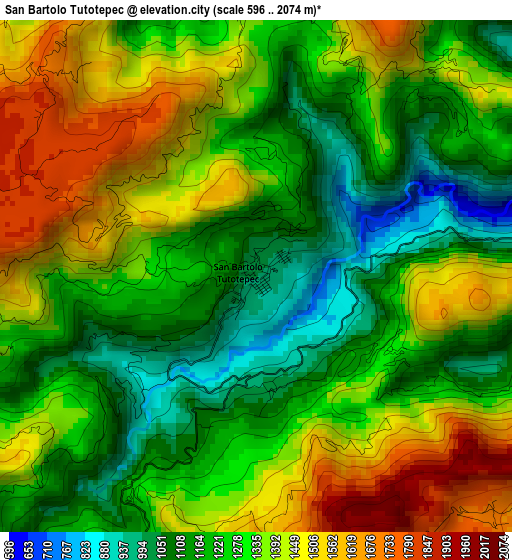
Below is the Elevation map of San Bartolo Tutotepec, which displays elevation range with different colors. Scale of the first map is from 596 to 2074 m (1955 to 6804 ft) with average elevation of 1307.5 meters (=4290 ft) [note 1]
These maps also provides idea of topography and contour of this city, they are displayed at different zoom levels. More info about maps, scale and edge coordinates you can find below images.
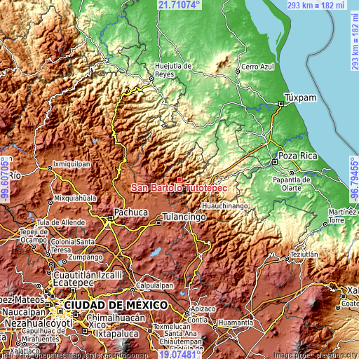
| \ | Map #1 | Topo.Map |
| Scale [m] | 596..2074 m | × |
| Scale [ft] | 1955..6804 ft | × |
| Average | 1307.5 m = 4290 ft | × |
| Width | 9.16 km = 5.7 mi | 293.1 km = 182.1 mi |
| Height | 9.16 km = 5.7 mi | 293.1 km = 182.1 mi |
| ↑Max Latitude | 20.439594° | 21.71074° |
| Latitude at center | 20.39841° | 20.39841° |
| ↓Min Latitude | 20.357215° | 19.07481° |
| ← Min Longitude | -98.244745° | -99.60705° |
| Longitude center | -98.2008° | -98.2008° |
| →Max Longitude | -98.156855° | -96.79455° |
Nearby cities:
Cities around San Bartolo Tutotepec sort by population:
• Pahuatlán de Valle elevation 1067 m
14.4 km,  158°
158°
• San Pablito 1183 m
11.6 km, 159°
• Huehuetla 426 m
14.7 km,  61°
61°
• Tenango de Doria 1639 m
7.3 km,  203°
203°
• Atla 1128 m
15.8 km,  149°
149°
• Chila de Juárez 1601 m
13.1 km,  183°
183°
• San Nicolás 1721 m
8.6 km,  170°
170°
• Santa Úrsula 937 m
10.3 km,  76°
76°
• Santa Mónica 1690 m
10.2 km,  190°
190°
• San Andrés 1241 m
15.9 km,  43°
43°
• San Pablo el Grande 1700 m
5.9 km,  134°
134°
• Barrio Aztlán 506 m
14.1 km, 58°
Multilingual:
 En español:
San Bartolo Tutotepec elevación 986 m.
 En France:
San Bartolo Tutotepec élévation 986 m.
 Auf Deutsch:
San Bartolo Tutotepec höhe über dem Meeresspiegel ist 986 m.
 На русском:
San Bartolo Tutotepec высота над уровнем моря 986 м
Sources and notes:
- [note 1] Map square and city borders are not equal. Map elevation data is calculated only from area inside that square.
- [src 1] Elevation data from geonames database provided with same terms of usage.
- [src 2] The elevation map of San Bartolo Tutotepec is generated using elevation data from NASA's 3 arcsec (90m) resolution SRTM data.
- [src 3] Base (background) map © OpenStreetMap contributors tiles are generated by Geofabrik and OpenTopoMap.
Copyright & License:
This San Bartolo Tutotepec Elevation Map is licensed under CC BY-SA. You may reuse any part from this page, if you give a proper credit by linking to this URL:
 More info on terms of use page.