San Luis Ayucán elevation
San Luis Ayucán (Morelos), Mexico elevation is 2717 meters and San Luis Ayucán elevation in feet is 8914 ft above sea level [src 1]. San Luis Ayucán is a populated place (feature code) with elevation that is 1403 meters (4603 ft) bigger than average city elevation in Mexico.
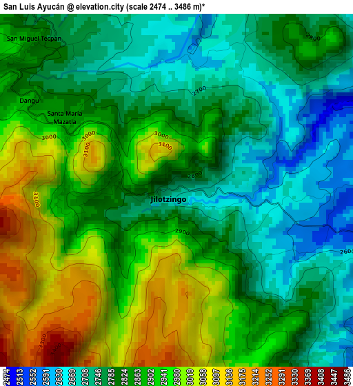
Below is the Elevation map of San Luis Ayucán, which displays elevation range with different colors. Scale of the first map is from 2474 to 3486 m (8117 to 11437 ft) with average elevation of 2858.1 meters (=9377 ft) [note 1]
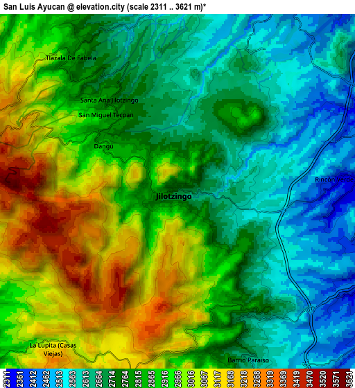
These maps also provides idea of topography and contour of this city, they are displayed at different zoom levels. More info about maps, scale and edge coordinates you can find below images.
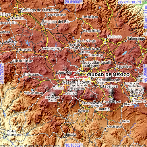
| \ | Map #1 | Map #2 | Topo.Map |
| Scale [m] | 2474..3486 m | 2311..3621 m | × |
| Scale [ft] | 8117..11437 ft | 7582..11880 ft | × |
| Average | 2858.1 m = 9377 ft | 2826.4 m = 9273 ft | × |
| Width | 9.21 km = 5.7 mi | 18.42 km = 11.4 mi | 294.8 km = 183.2 mi |
| Height | 9.21 km = 5.7 mi | 18.42 km = 11.4 mi | 294.8 km = 183.2 mi |
| ↑Max Latitude | 19.53739° | 19.5788° | 20.81606° |
| Latitude at center | 19.49597° | 19.49597° | 19.49597° |
| ↓Min Latitude | 19.454539° | 19.413097° | 18.16502° |
| ← Min Longitude | -99.407065° | -99.451011° | -100.76937° |
| Longitude center | -99.36312° | -99.36312° | -99.36312° |
| →Max Longitude | -99.319175° | -99.275229° | -97.95687° |
Nearby cities:
Cities around San Luis Ayucán sort by population:
• San Francisco Chimalpa elevation 2884 m
6.2 km,  161°
161°
• Santiago Tepatlaxco 2724 m
3.1 km,  139°
139°
• Santa María Mazatla 2826 m
3.3 km,  310°
310°
• El Hielo 3071 m
7.8 km,  174°
174°
• San José Tejamanil 3004 m
7.2 km,  176°
176°
• Barrio San Miguel Dorami 2870 m
5.9 km, 159°
• La Rosa 2554 m
3.7 km,  108°
108°
• San Miguel Tecpan 2830 m
5.4 km,  317°
317°
• Barrio de Ensido 2778 m
1.2 km,  258°
258°
• Rincón Verde 2366 m
7.6 km,  89°
89°
• Chimalpa Viejo 2893 m
5.5 km, 159°
• Santa Ana Jilotzingo 2767 m
6 km,  326°
326°
Multilingual:
 En español:
San Luis Ayucán elevación 2717 m.
 En France:
San Luis Ayucán élévation 2717 m.
 Auf Deutsch:
San Luis Ayucán höhe über dem Meeresspiegel ist 2717 m.

Sources and notes:
- [note 1] Map square and city borders are not equal. Map elevation data is calculated only from area inside that square.
- [src 1] Elevation data from geonames database provided with same terms of usage.
- [src 2] The elevation map of San Luis Ayucán is generated using elevation data from NASA's 3 arcsec (90m) resolution SRTM data.
- [src 3] Base (background) map © OpenStreetMap contributors tiles are generated by Geofabrik and OpenTopoMap.
Copyright & License:
This San Luis Ayucán Elevation Map is licensed under CC BY-SA. You may reuse any part from this page, if you give a proper credit by linking to this URL:
 More info on terms of use page.