Teolocholco elevation
Teolocholco (Tlaxcala), Mexico elevation is 2328 meters and Teolocholco elevation in feet is 7638 ft above sea level [src 1]. Teolocholco is a populated place (feature code) with elevation that is 1014 meters (3327 ft) bigger than average city elevation in Mexico.
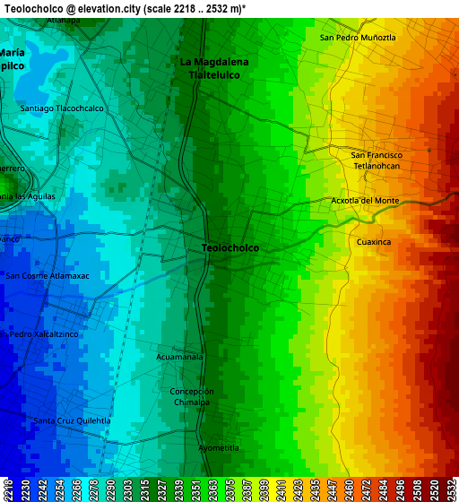
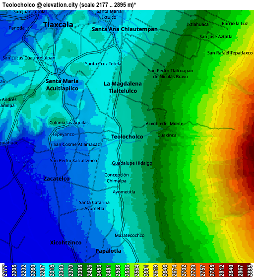
Below is the Elevation map of Teolocholco, which displays elevation range with different colors. Scale of the first map is from 2218 to 2532 m (7277 to 8307 ft) with average elevation of 2346.6 meters (=7699 ft) [note 1]
These maps also provides idea of topography and contour of this city, they are displayed at different zoom levels. More info about maps, scale and edge coordinates you can find below images.
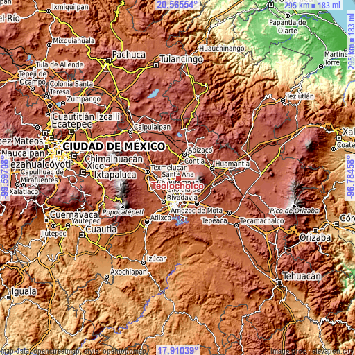
| \ | Map #1 | Map #2 | Topo.Map |
| Scale [m] | 2218..2532 m | 2177..2895 m | × |
| Scale [ft] | 7277..8307 ft | 7142..9498 ft | × |
| Average | 2346.6 m = 7699 ft | 2379.9 m = 7808 ft | × |
| Width | 9.23 km = 5.7 mi | 18.45 km = 11.5 mi | 295.2 km = 183.4 mi |
| Height | 9.23 km = 5.7 mi | 18.45 km = 11.5 mi | 295.2 km = 183.4 mi |
| ↑Max Latitude | 19.284815° | 19.326289° | 20.56554° |
| Latitude at center | 19.24333° | 19.24333° | 19.24333° |
| ↓Min Latitude | 19.201835° | 19.160329° | 17.91039° |
| ← Min Longitude | -98.234775° | -98.278721° | -99.59708° |
| Longitude center | -98.19083° | -98.19083° | -98.19083° |
| →Max Longitude | -98.146885° | -98.102939° | -96.78458° |
Nearby cities:
Cities around Teolocholco sort by population:
• San Francisco Tetlanohcan elevation 2434 m
3.4 km,  56°
56°
• Tetlanohcán 2431 m
3.4 km, 55°
• Santa Isabel Xiloxoxtla 2286 m
3.7 km,  318°
318°
• El Carmen Aztama 2253 m
3.4 km,  243°
243°
• San Cosme Atlamaxac 2250 m
3.6 km,  261°
261°
• Acxotla del Monte 2408 m
2.6 km,  68°
68°
• San Pedro Xalcaltzinco 2239 m
4.3 km,  246°
246°
• Ayometitla 2327 m
4 km,  183°
183°
• Acuamanala 2301 m
2.4 km,  204°
204°
• Concepción Chimalpa 2309 m
3.1 km,  194°
194°
• Guadalupe Hidalgo 2349 m
1.9 km,  169°
169°
• La Aurora 2284 m
3.7 km,  293°
293°
Multilingual:
 En español:
Teolocholco elevación 2328 m.
 En France:
Teolocholco élévation 2328 m.
 Auf Deutsch:
Teolocholco höhe über dem Meeresspiegel ist 2328 m.

Sources and notes:
- [note 1] Map square and city borders are not equal. Map elevation data is calculated only from area inside that square.
- [src 1] Elevation data from geonames database provided with same terms of usage.
- [src 2] The elevation map of Teolocholco is generated using elevation data from NASA's 3 arcsec (90m) resolution SRTM data.
- [src 3] Base (background) map © OpenStreetMap contributors tiles are generated by Geofabrik and OpenTopoMap.
Copyright & License:
This Teolocholco Elevation Map is licensed under CC BY-SA. You may reuse any part from this page, if you give a proper credit by linking to this URL:
 More info on terms of use page.