Santa Isabel Xiloxoxtla elevation
Santa Isabel Xiloxoxtla (Tlaxcala), Mexico elevation is 2286 meters and Santa Isabel Xiloxoxtla elevation in feet is 7500 ft above sea level [src 1]. Santa Isabel Xiloxoxtla is a seat of a second-order administrative division (feature code) with elevation that is 972 meters (3189 ft) bigger than average city elevation in Mexico.
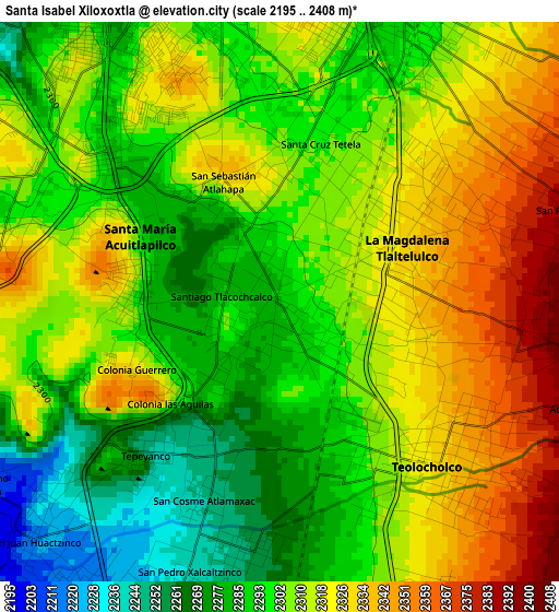
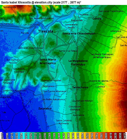
Below is the Elevation map of Santa Isabel Xiloxoxtla, which displays elevation range with different colors. Scale of the first map is from 2195 to 2408 m (7201 to 7900 ft) with average elevation of 2306.1 meters (=7566 ft) [note 1]
These maps also provides idea of topography and contour of this city, they are displayed at different zoom levels. More info about maps, scale and edge coordinates you can find below images.
| \ | Map #1 | Map #2 | Topo.Map |
| Scale [m] | 2195..2408 m | 2177..2677 m | × |
| Scale [ft] | 7201..7900 ft | 7142..8783 ft | × |
| Average | 2306.1 m = 7566 ft | 2329.2 m = 7642 ft | × |
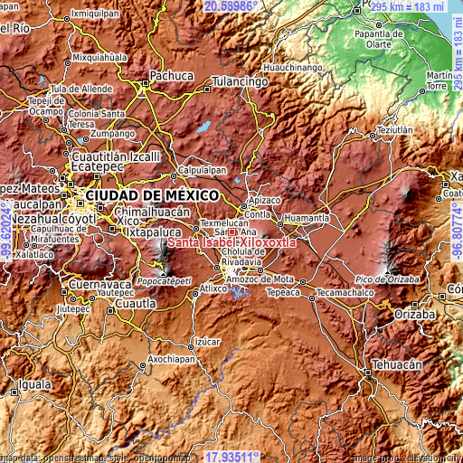
| Width | 9.23 km = 5.7 mi | 18.45 km = 11.5 mi | 295.2 km = 183.4 mi |
| Height | 9.23 km = 5.7 mi | 18.45 km = 11.5 mi | 295.2 km = 183.4 mi |
| ↑Max Latitude | 19.309339° | 19.350807° | 20.58986° |
| Latitude at center | 19.26786° | 19.26786° | 19.26786° |
| ↓Min Latitude | 19.226371° | 19.184871° | 17.93511° |
| ← Min Longitude | -98.257935° | -98.301881° | -99.62024° |
| Longitude center | -98.21399° | -98.21399° | -98.21399° |
| →Max Longitude | -98.170045° | -98.126099° | -96.80774° |
Nearby cities:
Cities around Santa Isabel Xiloxoxtla sort by population:
• Santa Ana Chiautempan elevation 2301 m
5.1 km,  32°
32°
• La Magdalena Tlaltelulco 2326 m
2.5 km,  48°
48°
• Teolocholco 2328 m
3.7 km,  138°
138°
• Acuitlapilco 2300 m
2.3 km,  285°
285°
• Tepeyanco 2243 m
3.3 km,  220°
220°
• Santa Cruz Tetela 2300 m
2.8 km,  13°
13°
• El Carmen Aztama 2253 m
4.3 km,  187°
187°
• San Cosme Atlamaxac 2250 m
3.5 km,  199°
199°
• San Pedro Xalcaltzinco 2239 m
4.7 km, 198°
• Acuamanala 2301 m
5.1 km,  164°
164°
• La Aurora 2284 m
1.6 km, 218°
• Santiago Tlacochcalco 2285 m
1 km,  275°
275°
Multilingual:
 En español:
Santa Isabel Xiloxoxtla elevación 2286 m.
 En France:
Santa Isabel Xiloxoxtla élévation 2286 m.
 Auf Deutsch:
Santa Isabel Xiloxoxtla höhe über dem Meeresspiegel ist 2286 m.
 На русском:
Santa Isabel Xiloxoxtla высота над уровнем моря 2286 м
Sources and notes:
- [note 1] Map square and city borders are not equal. Map elevation data is calculated only from area inside that square.
- [src 1] Elevation data from geonames database provided with same terms of usage.
- [src 2] The elevation map of Santa Isabel Xiloxoxtla is generated using elevation data from NASA's 3 arcsec (90m) resolution SRTM data.
- [src 3] Base (background) map © OpenStreetMap contributors tiles are generated by Geofabrik and OpenTopoMap.
Copyright & License:
This Santa Isabel Xiloxoxtla Elevation Map is licensed under CC BY-SA. You may reuse any part from this page, if you give a proper credit by linking to this URL:
 More info on terms of use page.