San Marcos elevation
San Marcos (Guerrero), Mexico elevation is 90 meters and San Marcos elevation in feet is 295 ft above sea level [src 1]. San Marcos is a seat of a second-order administrative division (feature code) with elevation that is 1224 meters (4016 ft) smaller than average city elevation in Mexico.
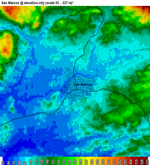
Below is the Elevation map of San Marcos, which displays elevation range with different colors. Scale of the first map is from 53 to 337 m (174 to 1106 ft) with average elevation of 115.5 meters (=379 ft) [note 1]
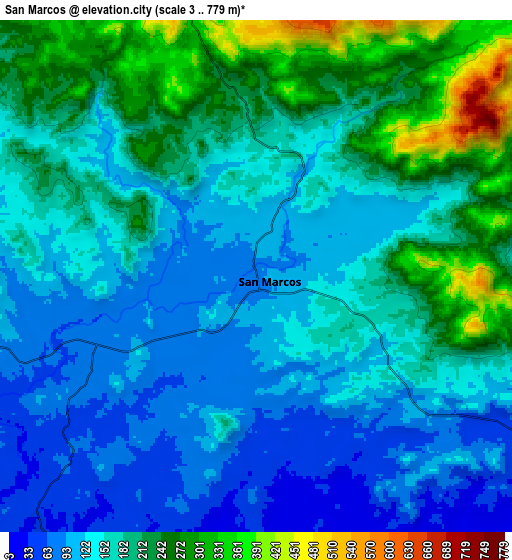
These maps also provides idea of topography and contour of this city, they are displayed at different zoom levels. More info about maps, scale and edge coordinates you can find below images.
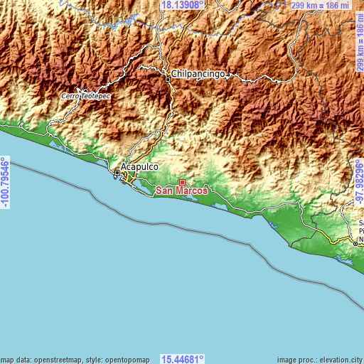
| \ | Map #1 | Map #2 | Topo.Map |
| Scale [m] | 53..337 m | 3..779 m | × |
| Scale [ft] | 174..1106 ft | 10..2556 ft | × |
| Average | 115.5 m = 379 ft | 166.8 m = 547 ft | × |
| Width | 9.36 km = 5.8 mi | 18.71 km = 11.6 mi | 299.4 km = 186 mi |
| Height | 9.36 km = 5.8 mi | 18.71 km = 11.6 mi | 299.4 km = 186 mi |
| ↑Max Latitude | 16.839786° | 16.881842° | 18.13908° |
| Latitude at center | 16.79772° | 16.79772° | 16.79772° |
| ↓Min Latitude | 16.755645° | 16.713561° | 15.44681° |
| ← Min Longitude | -99.433155° | -99.477101° | -100.79546° |
| Longitude center | -99.38921° | -99.38921° | -99.38921° |
| →Max Longitude | -99.345265° | -99.301319° | -97.98296° |
Nearby cities:
Cities around San Marcos sort by population:
• Las Vigas elevation 34 m
17.5 km,  103°
103°
• Huamuchapa 727 m
17.9 km,  24°
24°
• Las Cruces 426 m
20.4 km,  343°
343°
• Las Ánimas 661 m
20.8 km, 20°
• Villa Hermosa 762 m
16.9 km, 21°
• Llano Grande 325 m
16.5 km, 343°
• Llano de la Puerta 75 m
15.9 km,  247°
247°
• Ocotlán 471 m
15.9 km,  7°
7°
• El Cortés 86 m
12.2 km,  261°
261°
• Campanario 177 m
19.9 km,  282°
282°
• Barrio Nuevo de los Muertos 225 m
19.6 km,  302°
302°
• Rancho Viejo 378 m
13 km,  54°
54°
Multilingual:
 En español:
San Marcos elevación 90 m.
 En France:
San Marcos élévation 90 m.
 Auf Deutsch:
San Marcos höhe über dem Meeresspiegel ist 90 m.

Sources and notes:
- [note 1] Map square and city borders are not equal. Map elevation data is calculated only from area inside that square.
- [src 1] Elevation data from geonames database provided with same terms of usage.
- [src 2] The elevation map of San Marcos is generated using elevation data from NASA's 3 arcsec (90m) resolution SRTM data.
- [src 3] Base (background) map © OpenStreetMap contributors tiles are generated by Geofabrik and OpenTopoMap.
Copyright & License:
This San Marcos Elevation Map is licensed under CC BY-SA. You may reuse any part from this page, if you give a proper credit by linking to this URL:
 More info on terms of use page.