San Mateo elevation
San Mateo (State of Mexico, Amanalco), Mexico elevation is 2422 meters and San Mateo elevation in feet is 7946 ft above sea level [src 1]. San Mateo is a populated place (feature code) with elevation that is 1108 meters (3635 ft) bigger than average city elevation in Mexico.
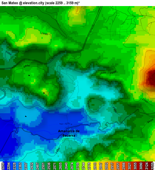
Below is the Elevation map of San Mateo, which displays elevation range with different colors. Scale of the first map is from 2259 to 3159 m (7411 to 10364 ft) with average elevation of 2561.2 meters (=8403 ft) [note 1]
These maps also provides idea of topography and contour of this city, they are displayed at different zoom levels. More info about maps, scale and edge coordinates you can find below images.
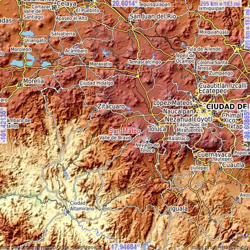
| \ | Map #1 | Topo.Map |
| Scale [m] | 2259..3159 m | × |
| Scale [ft] | 7411..10364 ft | × |
| Average | 2561.2 m = 8403 ft | × |
| Width | 9.22 km = 5.7 mi | 295.2 km = 183.4 mi |
| Height | 9.22 km = 5.7 mi | 295.2 km = 183.4 mi |
| ↑Max Latitude | 19.320976° | 20.6014° |
| Latitude at center | 19.2795° | 19.2795° |
| ↓Min Latitude | 19.238014° | 17.94684° |
| ← Min Longitude | -100.059045° | -101.42135° |
| Longitude center | -100.0151° | -100.0151° |
| →Max Longitude | -99.971155° | -98.60885° |
Nearby cities:
Cities around San Mateo sort by population:
• Amanalco de Becerra elevation 2807 m
4.1 km,  357°
357°
• San Simón de la Laguna 2487 m
7 km,  282°
282°
• San Juan 2333 m
4 km,  203°
203°
• San Jerónimo 2459 m
4.2 km,  190°
190°
• San Bartolo 2276 m
5.6 km,  226°
226°
• San Martín Obispo (San Martín San Pedro) 2490 m
7.7 km,  305°
305°
• San Antonio de la Laguna 2493 m
6.4 km,  292°
292°
• San Miguel Xoltepec 2152 m
7.7 km,  247°
247°
• Amanalco de Becerra 2339 m
2.9 km, 189°
• San Lucas 2381 m
2.4 km,  159°
159°
• El Potrero 2668 m
3.7 km,  36°
36°
• Rincón de Guadalupe 2421 m
2 km,  107°
107°
Multilingual:
 En español:
San Mateo elevación 2422 m.
 En France:
San Mateo élévation 2422 m.
 Auf Deutsch:
San Mateo höhe über dem Meeresspiegel ist 2422 m.

Sources and notes:
- [note 1] Map square and city borders are not equal. Map elevation data is calculated only from area inside that square.
- [src 1] Elevation data from geonames database provided with same terms of usage.
- [src 2] The elevation map of San Mateo is generated using elevation data from NASA's 3 arcsec (90m) resolution SRTM data.
- [src 3] Base (background) map © OpenStreetMap contributors tiles are generated by Geofabrik and OpenTopoMap.
Copyright & License:
This San Mateo Elevation Map is licensed under CC BY-SA. You may reuse any part from this page, if you give a proper credit by linking to this URL:
 More info on terms of use page.