San Miguel Xoltepec elevation
San Miguel Xoltepec (State of Mexico, Donato Guerra), Mexico elevation is 2152 meters and San Miguel Xoltepec elevation in feet is 7060 ft above sea level [src 1]. San Miguel Xoltepec is a populated place (feature code) with elevation that is 838 meters (2749 ft) bigger than average city elevation in Mexico.
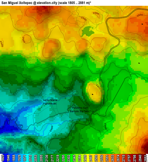
Below is the Elevation map of San Miguel Xoltepec, which displays elevation range with different colors. Scale of the first map is from 1805 to 2881 m (5922 to 9452 ft) with average elevation of 2312.5 meters (=7587 ft) [note 1]
These maps also provides idea of topography and contour of this city, they are displayed at different zoom levels. More info about maps, scale and edge coordinates you can find below images.
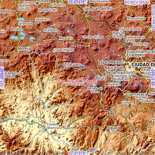
| \ | Map #1 | Topo.Map |
| Scale [m] | 1805..2881 m | × |
| Scale [ft] | 5922..9452 ft | × |
| Average | 2312.5 m = 7587 ft | × |
| Width | 9.23 km = 5.7 mi | 295.2 km = 183.4 mi |
| Height | 9.23 km = 5.7 mi | 295.2 km = 183.4 mi |
| ↑Max Latitude | 19.294132° | 20.57478° |
| Latitude at center | 19.25265° | 19.25265° |
| ↓Min Latitude | 19.211157° | 17.91978° |
| ← Min Longitude | -100.127145° | -101.48945° |
| Longitude center | -100.0832° | -100.0832° |
| →Max Longitude | -100.039255° | -98.67695° |
Nearby cities:
Cities around San Miguel Xoltepec sort by population:
• San Simón de la Laguna elevation 2487 m
4.5 km,  3°
3°
• San Juan 2333 m
5.6 km,  96°
96°
• San Jerónimo 2459 m
6.5 km, 99°
• San Bartolo 2276 m
3.3 km,  105°
105°
• San Francisco Mihualtepec 2050 m
1.8 km,  241°
241°
• El Arco 1814 m
5.9 km, 239°
• Santa María Pipioltepec (Pipioltepec) 2062 m
2 km,  228°
228°
• San Gabriel Ixtla 2189 m
4.3 km,  277°
277°
• San Antonio de la Laguna 2493 m
5.5 km,  12°
12°
• Polvillos (San Bartolo Quinta Sección) 2145 m
1.9 km,  169°
169°
• Amanalco de Becerra 2339 m
6.7 km,  88°
88°
• Colonia Rincón Villa del Valle 1900 m
6.1 km,  218°
218°
Multilingual:
 En español:
San Miguel Xoltepec elevación 2152 m.
 En France:
San Miguel Xoltepec élévation 2152 m.
 Auf Deutsch:
San Miguel Xoltepec höhe über dem Meeresspiegel ist 2152 m.
 На русском:
San Miguel Xoltepec высота над уровнем моря 2152 м
Sources and notes:
- [note 1] Map square and city borders are not equal. Map elevation data is calculated only from area inside that square.
- [src 1] Elevation data from geonames database provided with same terms of usage.
- [src 2] The elevation map of San Miguel Xoltepec is generated using elevation data from NASA's 3 arcsec (90m) resolution SRTM data.
- [src 3] Base (background) map © OpenStreetMap contributors tiles are generated by Geofabrik and OpenTopoMap.
Copyright & License:
This San Miguel Xoltepec Elevation Map is licensed under CC BY-SA. You may reuse any part from this page, if you give a proper credit by linking to this URL:
 More info on terms of use page.