San Mateo Sindihui elevation
San Mateo Sindihui (Oaxaca), Mexico elevation is 1474 meters and San Mateo Sindihui elevation in feet is 4836 ft above sea level [src 1]. San Mateo Sindihui is a populated place (feature code) with elevation that is 160 meters (525 ft) bigger than average city elevation in Mexico.
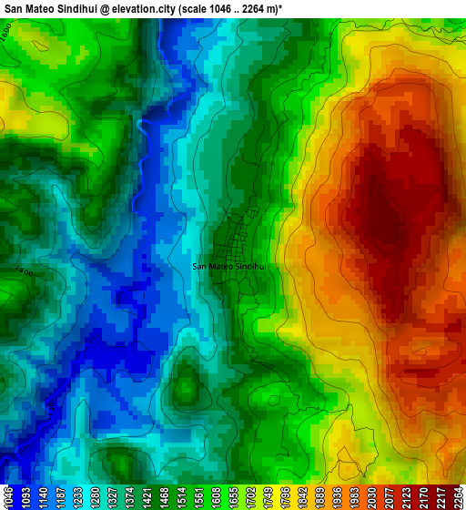
Below is the Elevation map of San Mateo Sindihui, which displays elevation range with different colors. Scale of the first map is from 1046 to 2264 m (3432 to 7428 ft) with average elevation of 1566.4 meters (=5139 ft) [note 1]
These maps also provides idea of topography and contour of this city, they are displayed at different zoom levels. More info about maps, scale and edge coordinates you can find below images.
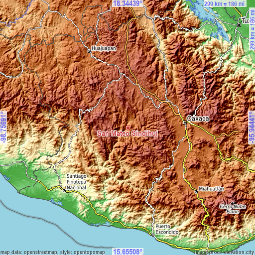
| \ | Map #1 | Topo.Map |
| Scale [m] | 1046..2264 m | × |
| Scale [ft] | 3432..7428 ft | × |
| Average | 1566.4 m = 5139 ft | × |
| Width | 9.35 km = 5.8 mi | 299 km = 185.8 mi |
| Height | 9.35 km = 5.8 mi | 299 km = 185.8 mi |
| ↑Max Latitude | 17.046579° | 18.34439° |
| Latitude at center | 17.00456° | 17.00456° |
| ↓Min Latitude | 16.962531° | 15.65508° |
| ← Min Longitude | -97.394605° | -98.75691° |
| Longitude center | -97.35066° | -97.35066° |
| →Max Longitude | -97.306715° | -95.94441° |
Nearby cities:
Cities around San Mateo Sindihui sort by population:
• Villa Chalcatongo de Hidalgo elevation 2478 m
23.6 km,  277°
277°
• San Antonio Huitepec 2343 m
23.3 km,  111°
111°
• Santiago Yosondúa 2196 m
27.9 km,  239°
239°
• San Juan Diuxi 2229 m
31.4 km,  356°
356°
• Yutanduchi de Guerrero 1628 m
6.9 km,  54°
54°
• Santiago Huaxolotipac 1804 m
28.3 km,  96°
96°
• Progreso 2460 m
23.8 km, 280°
• San Miguel el Grande Villa Juárez 2472 m
29.2 km, 279°
• Santiago Textitlán 1734 m
36 km,  164°
164°
• San Esteban Atatlahuca 2511 m
35.5 km, 281°
• Santiago Tilantongo 2205 m
31.2 km,  2°
2°
• San Miguel Achiutla 2003 m
36.7 km,  337°
337°
Multilingual:
 En español:
San Mateo Sindihui elevación 1474 m.
 En France:
San Mateo Sindihui élévation 1474 m.
 Auf Deutsch:
San Mateo Sindihui höhe über dem Meeresspiegel ist 1474 m.
 На русском:
San Mateo Sindihui высота над уровнем моря 1474 м
Sources and notes:
- [note 1] Map square and city borders are not equal. Map elevation data is calculated only from area inside that square.
- [src 1] Elevation data from geonames database provided with same terms of usage.
- [src 2] The elevation map of San Mateo Sindihui is generated using elevation data from NASA's 3 arcsec (90m) resolution SRTM data.
- [src 3] Base (background) map © OpenStreetMap contributors tiles are generated by Geofabrik and OpenTopoMap.
Copyright & License:
This San Mateo Sindihui Elevation Map is licensed under CC BY-SA. You may reuse any part from this page, if you give a proper credit by linking to this URL:
 More info on terms of use page.