San Miguel Achiutla elevation
San Miguel Achiutla (Oaxaca), Mexico elevation is 2003 meters and San Miguel Achiutla elevation in feet is 6572 ft above sea level [src 1]. San Miguel Achiutla is a seat of a second-order administrative division (feature code) with elevation that is 689 meters (2260 ft) bigger than average city elevation in Mexico.
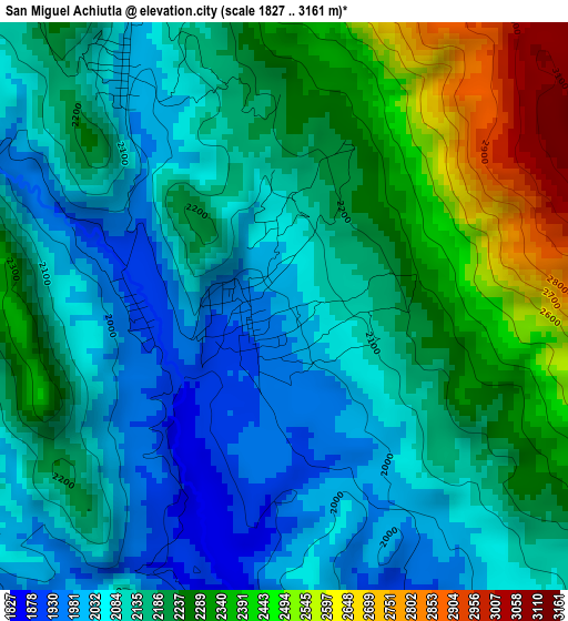
Below is the Elevation map of San Miguel Achiutla, which displays elevation range with different colors. Scale of the first map is from 1827 to 3161 m (5994 to 10371 ft) with average elevation of 2183.8 meters (=7165 ft) [note 1]
These maps also provides idea of topography and contour of this city, they are displayed at different zoom levels. More info about maps, scale and edge coordinates you can find below images.
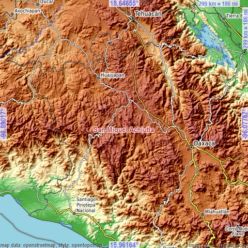
| \ | Map #1 | Topo.Map |
| Scale [m] | 1827..3161 m | × |
| Scale [ft] | 5994..10371 ft | × |
| Average | 2183.8 m = 7165 ft | × |
| Width | 9.33 km = 5.8 mi | 298.5 km = 185.5 mi |
| Height | 9.33 km = 5.8 mi | 298.6 km = 185.5 mi |
| ↑Max Latitude | 17.35095° | 18.64655° |
| Latitude at center | 17.309° | 17.309° |
| ↓Min Latitude | 17.26704° | 15.96164° |
| ← Min Longitude | -97.527865° | -98.89017° |
| Longitude center | -97.48392° | -97.48392° |
| →Max Longitude | -97.439975° | -96.07767° |
Nearby cities:
Cities around San Miguel Achiutla sort by population:
• San Juan Diuxi elevation 2229 m
12.4 km,  101°
101°
• Magdalena Yodocono de Porfirio Díaz 2304 m
16 km,  58°
58°
• San Pedro Tidaá 2276 m
12.4 km,  73°
73°
• Santiago Tilantongo 2205 m
15.6 km, 99°
• San Cristóbal Amoltepec 2307 m
9.8 km,  253°
253°
• San Vicente Nuñu 2377 m
17 km,  14°
14°
• Santa Catarina Tayata 2113 m
9 km,  298°
298°
• Santiago Nejapilla 2255 m
17 km,  43°
43°
• San Juan Achiutla 2030 m
5.2 km,  330°
330°
• Santa Cruz Tayata 2143 m
10.4 km, 300°
• Santa María Nduayaco 2346 m
11.3 km,  354°
354°
• Santa María del Rosario 2329 m
12.7 km,  292°
292°
Multilingual:
 En español:
San Miguel Achiutla elevación 2003 m.
 En France:
San Miguel Achiutla élévation 2003 m.
 Auf Deutsch:
San Miguel Achiutla höhe über dem Meeresspiegel ist 2003 m.
 На русском:
San Miguel Achiutla высота над уровнем моря 2003 м
Sources and notes:
- [note 1] Map square and city borders are not equal. Map elevation data is calculated only from area inside that square.
- [src 1] Elevation data from geonames database provided with same terms of usage.
- [src 2] The elevation map of San Miguel Achiutla is generated using elevation data from NASA's 3 arcsec (90m) resolution SRTM data.
- [src 3] Base (background) map © OpenStreetMap contributors tiles are generated by Geofabrik and OpenTopoMap.
Copyright & License:
This San Miguel Achiutla Elevation Map is licensed under CC BY-SA. You may reuse any part from this page, if you give a proper credit by linking to this URL:
 More info on terms of use page.