Apetatitlán Antonio Carbajal elevation
Apetatitlán Antonio Carbajal (Tlaxcala, Contla de Juan Cuamatzi), Mexico elevation is 2291 meters and Apetatitlán Antonio Carbajal elevation in feet is 7516 ft above sea level [src 1]. Apetatitlán Antonio Carbajal is a populated place (feature code) with elevation that is 977 meters (3205 ft) bigger than average city elevation in Mexico.
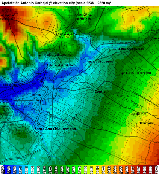
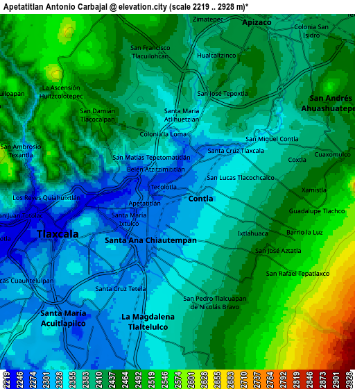
Below is the Elevation map of Apetatitlán Antonio Carbajal, which displays elevation range with different colors. Scale of the first map is from 2238 to 2520 m (7343 to 8268 ft) with average elevation of 2340.7 meters (=7679 ft) [note 1]
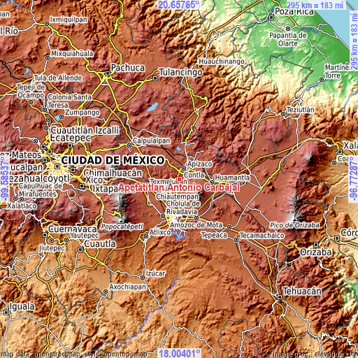
These maps also provides idea of topography and contour of this city, they are displayed at different zoom levels. More info about maps, scale and edge coordinates you can find below images.
| \ | Map #1 | Map #2 | Topo.Map |
| Scale [m] | 2238..2520 m | 2219..2928 m | × |
| Scale [ft] | 7343..8268 ft | 7280..9606 ft | × |
| Average | 2340.7 m = 7679 ft | 2411.1 m = 7910 ft | × |
| Width | 9.22 km = 5.7 mi | 18.44 km = 11.5 mi | 295.1 km = 183.4 mi |
| Height | 9.22 km = 5.7 mi | 18.44 km = 11.5 mi | 295.1 km = 183.4 mi |
| ↑Max Latitude | 19.377681° | 19.419132° | 20.65765° |
| Latitude at center | 19.33622° | 19.33622° | 19.33622° |
| ↓Min Latitude | 19.294748° | 19.253266° | 18.00401° |
| ← Min Longitude | -98.223065° | -98.267011° | -99.58537° |
| Longitude center | -98.17912° | -98.17912° | -98.17912° |
| →Max Longitude | -98.135175° | -98.091229° | -96.77287° |
Nearby cities:
Cities around Apetatitlán Antonio Carbajal sort by population:
• Tlaxcala elevation 2277 m
2.9 km,  228°
228°
• Santa Ana Chiautempan 2301 m
3.4 km,  195°
195°
• Contla 2327 m
1.5 km,  119°
119°
• Amaxac de Guerrero 2303 m
1.5 km,  37°
37°
• San Esteban Tizatlán 2280 m
3.6 km,  275°
275°
• Santa María Ixtulco 2264 m
3.3 km,  248°
248°
• Santa Cruz Tlaxcala 2325 m
3.6 km,  55°
55°
• Belén Atzitzimititlán 2310 m
1.7 km,  316°
316°
• Tlatempan 2275 m
2.6 km,  258°
258°
• Santa María Atlihuetzian 2385 m
4.5 km,  1°
1°
• San Matías Tepetomatitlán 2339 m
2.6 km, 319°
• San Lucas Tlacochcalco 2358 m
3.5 km,  78°
78°
Multilingual:
 En español:
Apetatitlán Antonio Carbajal elevación 2291 m.
 En France:
Apetatitlán Antonio Carbajal élévation 2291 m.
 Auf Deutsch:
Apetatitlán Antonio Carbajal höhe über dem Meeresspiegel ist 2291 m.
 На русском:
Apetatitlán Antonio Carbajal высота над уровнем моря 2291 м
Sources and notes:
- [note 1] Map square and city borders are not equal. Map elevation data is calculated only from area inside that square.
- [src 1] Elevation data from geonames database provided with same terms of usage.
- [src 2] The elevation map of Apetatitlán Antonio Carbajal is generated using elevation data from NASA's 3 arcsec (90m) resolution SRTM data.
- [src 3] Base (background) map © OpenStreetMap contributors tiles are generated by Geofabrik and OpenTopoMap.
Copyright & License:
This Apetatitlán Antonio Carbajal Elevation Map is licensed under CC BY-SA. You may reuse any part from this page, if you give a proper credit by linking to this URL:
 More info on terms of use page.