San Pedro y San Pablo Tequistepec elevation
San Pedro y San Pablo Tequistepec (Oaxaca, San Pedro y San Pablo Teposcolula), Mexico elevation is 1855 meters and San Pedro y San Pablo Tequistepec elevation in feet is 6086 ft above sea level [src 1]. San Pedro y San Pablo Tequistepec is a seat of a second-order administrative division (feature code) with elevation that is 541 meters (1775 ft) bigger than average city elevation in Mexico.
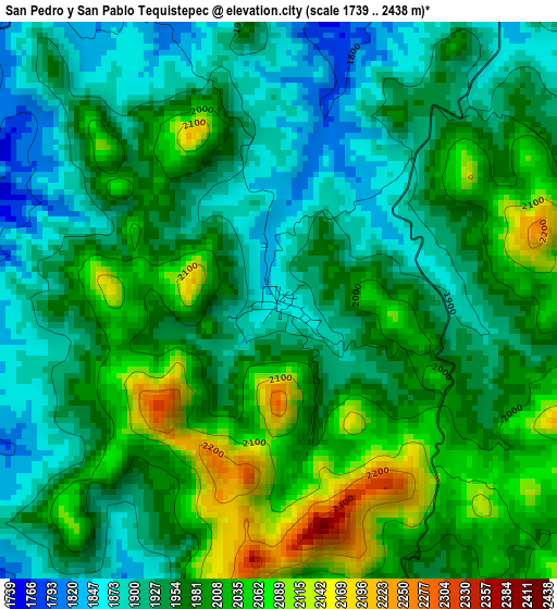
Below is the Elevation map of San Pedro y San Pablo Tequistepec, which displays elevation range with different colors. Scale of the first map is from 1739 to 2438 m (5705 to 7999 ft) with average elevation of 1968.1 meters (=6457 ft) [note 1]
These maps also provides idea of topography and contour of this city, they are displayed at different zoom levels. More info about maps, scale and edge coordinates you can find below images.
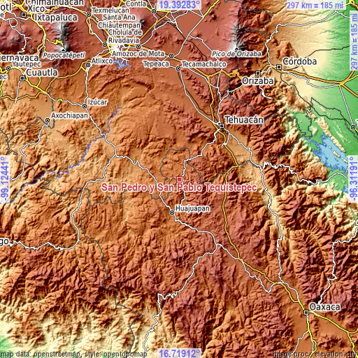
| \ | Map #1 | Topo.Map |
| Scale [m] | 1739..2438 m | × |
| Scale [ft] | 5705..7999 ft | × |
| Average | 1968.1 m = 6457 ft | × |
| Width | 9.29 km = 5.8 mi | 297.3 km = 184.7 mi |
| Height | 9.29 km = 5.8 mi | 297.3 km = 184.7 mi |
| ↑Max Latitude | 18.102835° | 19.39283° |
| Latitude at center | 18.06106° | 18.06106° |
| ↓Min Latitude | 18.019275° | 16.71912° |
| ← Min Longitude | -97.762105° | -99.12441° |
| Longitude center | -97.71816° | -97.71816° |
| →Max Longitude | -97.674215° | -96.31191° |
Nearby cities:
Cities around San Pedro y San Pablo Tequistepec sort by population:
• Petlalcingo elevation 1372 m
21.2 km,  277°
277°
• Santiago Huajolotitlán 1641 m
26 km,  183°
183°
• Chila 1634 m
18.2 km,  236°
236°
• Santiago Chazumba 1720 m
14.9 km,  15°
15°
• Santa María Camotlán 1728 m
18.5 km,  171°
171°
• Zapotitlán Palmas 1918 m
21.8 km,  209°
209°
• Francisco Ibarra Ramos 1716 m
23 km,  246°
246°
• Santiago Chilixtlahuaca 1672 m
25.5 km,  227°
227°
• Totoltepec de Guerrero 1379 m
23.3 km,  321°
321°
• San Miguel Ixitlán 1712 m
9 km,  221°
221°
• Cosoltepec 1833 m
11.9 km, 319°
• Santiago Miltepec 1854 m
9 km,  160°
160°
Multilingual:
 En español:
San Pedro y San Pablo Tequistepec elevación 1855 m.
 En France:
San Pedro y San Pablo Tequistepec élévation 1855 m.
 Auf Deutsch:
San Pedro y San Pablo Tequistepec höhe über dem Meeresspiegel ist 1855 m.
 На русском:
San Pedro y San Pablo Tequistepec высота над уровнем моря 1855 м
Sources and notes:
- [note 1] Map square and city borders are not equal. Map elevation data is calculated only from area inside that square.
- [src 1] Elevation data from geonames database provided with same terms of usage.
- [src 2] The elevation map of San Pedro y San Pablo Tequistepec is generated using elevation data from NASA's 3 arcsec (90m) resolution SRTM data.
- [src 3] Base (background) map © OpenStreetMap contributors tiles are generated by Geofabrik and OpenTopoMap.
Copyright & License:
This San Pedro y San Pablo Tequistepec Elevation Map is licensed under CC BY-SA. You may reuse any part from this page, if you give a proper credit by linking to this URL:
 More info on terms of use page.