Totoltepec de Guerrero elevation
Totoltepec de Guerrero (Puebla), Mexico elevation is 1379 meters and Totoltepec de Guerrero elevation in feet is 4524 ft above sea level [src 1]. Totoltepec de Guerrero is a seat of a second-order administrative division (feature code) with elevation that is 65 meters (213 ft) bigger than average city elevation in Mexico.
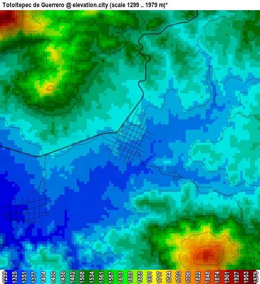
Below is the Elevation map of Totoltepec de Guerrero, which displays elevation range with different colors. Scale of the first map is from 1299 to 1979 m (4262 to 6493 ft) with average elevation of 1453.4 meters (=4768 ft) [note 1]
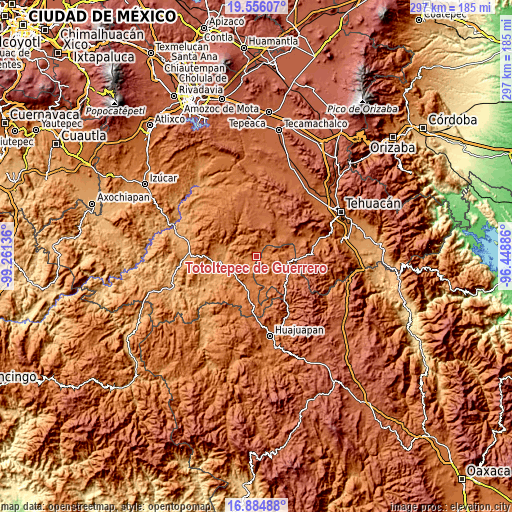
These maps also provides idea of topography and contour of this city, they are displayed at different zoom levels. More info about maps, scale and edge coordinates you can find below images.
| \ | Map #1 | Topo.Map |
| Scale [m] | 1299..1979 m | × |
| Scale [ft] | 4262..6493 ft | × |
| Average | 1453.4 m = 4768 ft | × |
| Width | 9.28 km = 5.8 mi | 297 km = 184.5 mi |
| Height | 9.28 km = 5.8 mi | 297 km = 184.5 mi |
| ↑Max Latitude | 18.267336° | 19.55607° |
| Latitude at center | 18.2256° | 18.2256° |
| ↓Min Latitude | 18.183854° | 16.88488° |
| ← Min Longitude | -97.899055° | -99.26136° |
| Longitude center | -97.85511° | -97.85511° |
| →Max Longitude | -97.811165° | -96.44886° |
Nearby cities:
Cities around Totoltepec de Guerrero sort by population:
• Acatlán de Osorio elevation 1185 m
20.6 km,  262°
262°
• San Vicente Boquerón 1286 m
22 km,  285°
285°
• Petlalcingo 1372 m
17 km,  202°
202°
• Santiago Chazumba 1720 m
18.9 km,  102°
102°
• San Felipe Otlaltepec 1855 m
20.3 km,  344°
344°
• Texcalapa de Juárez 1249 m
22.8 km,  218°
218°
• San Vicente Coyotepec 1897 m
20.1 km,  7°
7°
• Las Nieves 1180 m
20.7 km, 256°
• San Jerónimo Xayacatlán 1301 m
6.1 km, 264°
• Xayacatlán de Bravo 1251 m
12.8 km,  275°
275°
• Tetelcingo 1208 m
18.2 km,  274°
274°
• Cosoltepec 1833 m
11.5 km,  143°
143°
Multilingual:
 En español:
Totoltepec de Guerrero elevación 1379 m.
 En France:
Totoltepec de Guerrero élévation 1379 m.
 Auf Deutsch:
Totoltepec de Guerrero höhe über dem Meeresspiegel ist 1379 m.
 На русском:
Totoltepec de Guerrero высота над уровнем моря 1379 м
Sources and notes:
- [note 1] Map square and city borders are not equal. Map elevation data is calculated only from area inside that square.
- [src 1] Elevation data from geonames database provided with same terms of usage.
- [src 2] The elevation map of Totoltepec de Guerrero is generated using elevation data from NASA's 3 arcsec (90m) resolution SRTM data.
- [src 3] Base (background) map © OpenStreetMap contributors tiles are generated by Geofabrik and OpenTopoMap.
Copyright & License:
This Totoltepec de Guerrero Elevation Map is licensed under CC BY-SA. You may reuse any part from this page, if you give a proper credit by linking to this URL:
 More info on terms of use page.