Texcalapa de Juárez elevation
Texcalapa de Juárez (Puebla, Petlalcingo), Mexico elevation is 1249 meters and Texcalapa de Juárez elevation in feet is 4098 ft above sea level [src 1]. Texcalapa de Juárez is a populated place (feature code) with elevation that is 65 meters (213 ft) smaller than average city elevation in Mexico.
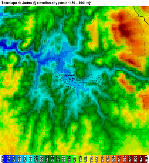
Below is the Elevation map of Texcalapa de Juárez, which displays elevation range with different colors. Scale of the first map is from 1180 to 1641 m (3871 to 5384 ft) with average elevation of 1371.9 meters (=4501 ft) [note 1]
These maps also provides idea of topography and contour of this city, they are displayed at different zoom levels. More info about maps, scale and edge coordinates you can find below images.
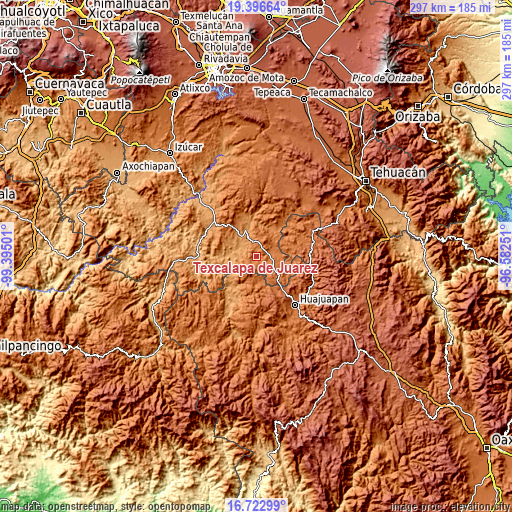
| \ | Map #1 | Topo.Map |
| Scale [m] | 1180..1641 m | × |
| Scale [ft] | 3871..5384 ft | × |
| Average | 1371.9 m = 4501 ft | × |
| Width | 9.29 km = 5.8 mi | 297.3 km = 184.7 mi |
| Height | 9.29 km = 5.8 mi | 297.3 km = 184.7 mi |
| ↑Max Latitude | 18.106674° | 19.39664° |
| Latitude at center | 18.0649° | 18.0649° |
| ↓Min Latitude | 18.023116° | 16.72299° |
| ← Min Longitude | -98.032705° | -99.39501° |
| Longitude center | -97.98876° | -97.98876° |
| →Max Longitude | -97.944815° | -96.58251° |
Nearby cities:
Cities around Texcalapa de Juárez sort by population:
• Acatlán de Osorio elevation 1185 m
16.6 km,  337°
337°
• Petlalcingo 1372 m
7.8 km,  73°
73°
• Guadalupe Santa Ana 1104 m
14.3 km,  281°
281°
• Chila 1634 m
17.2 km,  128°
128°
• San Pablo Anicano 1135 m
12.1 km,  302°
302°
• Amatitlán de Azueta 1165 m
15.5 km,  323°
323°
• Santiago Ayuquililla 1570 m
15 km,  167°
167°
• San Lorenzo Vista Hermosa 1538 m
14.5 km,  215°
215°
• Las Nieves 1180 m
14.5 km, 335°
• San Jerónimo Xayacatlán 1301 m
19.1 km,  24°
24°
• Francisco Ibarra Ramos 1716 m
12.3 km,  142°
142°
• San José Ayuquila 1556 m
13.8 km, 171°
Multilingual:
 En español:
Texcalapa de Juárez, Texcalapa elevación 1249 m.
 En France:
Texcalapa de Juárez élévation 1249 m.
 Auf Deutsch:
Texcalapa de Juárez höhe über dem Meeresspiegel ist 1249 m.
 На русском:
Texcalapa de Juárez высота над уровнем моря 1249 м
Sources and notes:
- [note 1] Map square and city borders are not equal. Map elevation data is calculated only from area inside that square.
- [src 1] Elevation data from geonames database provided with same terms of usage.
- [src 2] The elevation map of Texcalapa de Juárez is generated using elevation data from NASA's 3 arcsec (90m) resolution SRTM data.
- [src 3] Base (background) map © OpenStreetMap contributors tiles are generated by Geofabrik and OpenTopoMap.
Copyright & License:
This Texcalapa de Juárez Elevation Map is licensed under CC BY-SA. You may reuse any part from this page, if you give a proper credit by linking to this URL:
 More info on terms of use page.