Santa María Ajoloapan elevation
Santa María Ajoloapan (State of Mexico, Hueypoxtla), Mexico elevation is 2349 meters and Santa María Ajoloapan elevation in feet is 7707 ft above sea level [src 1]. Santa María Ajoloapan is a populated place (feature code) with elevation that is 1035 meters (3396 ft) bigger than average city elevation in Mexico.
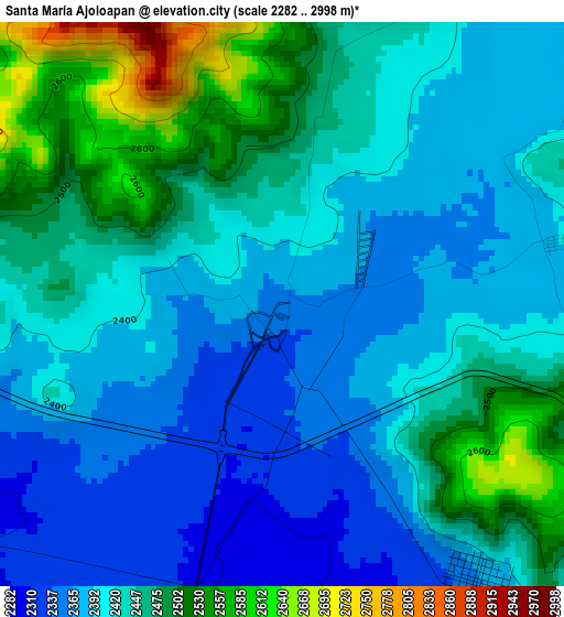
Below is the Elevation map of Santa María Ajoloapan, which displays elevation range with different colors. Scale of the first map is from 2282 to 2998 m (7487 to 9836 ft) with average elevation of 2427.3 meters (=7964 ft) [note 1]
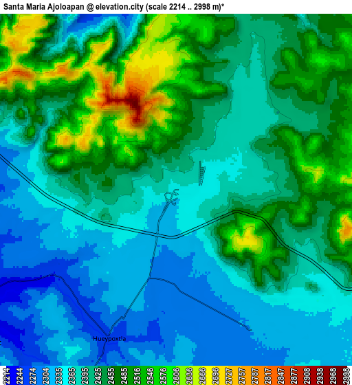
These maps also provides idea of topography and contour of this city, they are displayed at different zoom levels. More info about maps, scale and edge coordinates you can find below images.
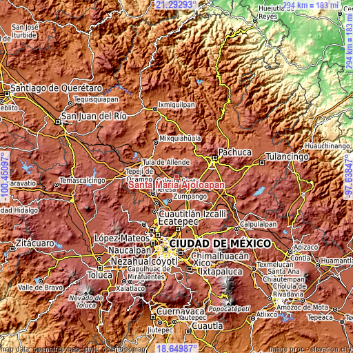
| \ | Map #1 | Map #2 | Topo.Map |
| Scale [m] | 2282..2998 m | 2214..2998 m | × |
| Scale [ft] | 7487..9836 ft | 7264..9836 ft | × |
| Average | 2427.3 m = 7964 ft | 2418.6 m = 7935 ft | × |
| Width | 9.18 km = 5.7 mi | 18.37 km = 11.4 mi | 293.9 km = 182.6 mi |
| Height | 9.18 km = 5.7 mi | 18.37 km = 11.4 mi | 293.9 km = 182.6 mi |
| ↑Max Latitude | 20.018236° | 20.059521° | 21.29293° |
| Latitude at center | 19.97694° | 19.97694° | 19.97694° |
| ↓Min Latitude | 19.935633° | 19.894316° | 18.64987° |
| ← Min Longitude | -99.088665° | -99.132611° | -100.45097° |
| Longitude center | -99.04472° | -99.04472° | -99.04472° |
| →Max Longitude | -99.000775° | -98.956829° | -97.63847° |
Nearby cities:
Cities around Santa María Ajoloapan sort by population:
• Tequixquiac elevation 2219 m
12.9 km,  234°
234°
• Jilotzingo 2328 m
12.1 km,  188°
188°
• San Francisco Zacacalco 2356 m
8.4 km,  129°
129°
• Tlapanaloya 2282 m
7.1 km, 230°
• Hueypoxtla 2275 m
7.7 km,  203°
203°
• Coyotillos 2255 m
12.1 km,  282°
282°
• Emiliano Zapata (San José Bata) 2305 m
8.3 km,  151°
151°
• Tianguistongo 2458 m
3.3 km,  11°
11°
• Pérez de Galeana 2279 m
10.1 km,  271°
271°
• Colonia Juárez 2254 m
11.1 km, 280°
• Colonia 3 de Mayo (La Cruz) 2222 m
12.4 km, 271°
• Oriental de Zapata 2367 m
1.6 km,  55°
55°
Multilingual:
 En español:
Santa María Ajoloapan elevación 2349 m.
 En France:
Santa María Ajoloapan élévation 2349 m.
 Auf Deutsch:
Santa María Ajoloapan höhe über dem Meeresspiegel ist 2349 m.
 На русском:
Santa María Ajoloapan высота над уровнем моря 2349 м
Sources and notes:
- [note 1] Map square and city borders are not equal. Map elevation data is calculated only from area inside that square.
- [src 1] Elevation data from geonames database provided with same terms of usage.
- [src 2] The elevation map of Santa María Ajoloapan is generated using elevation data from NASA's 3 arcsec (90m) resolution SRTM data.
- [src 3] Base (background) map © OpenStreetMap contributors tiles are generated by Geofabrik and OpenTopoMap.
Copyright & License:
This Santa María Ajoloapan Elevation Map is licensed under CC BY-SA. You may reuse any part from this page, if you give a proper credit by linking to this URL:
 More info on terms of use page.