Jilotzingo elevation
Jilotzingo (State of Mexico, Hueypoxtla), Mexico elevation is 2328 meters and Jilotzingo elevation in feet is 7638 ft above sea level [src 1]. Jilotzingo is a populated place (feature code) with elevation that is 1014 meters (3327 ft) bigger than average city elevation in Mexico.
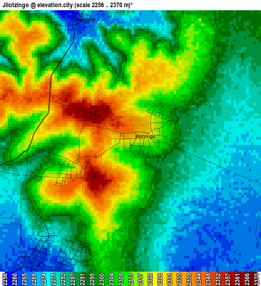
Below is the Elevation map of Jilotzingo, which displays elevation range with different colors. Scale of the first map is from 2256 to 2370 m (7402 to 7776 ft) with average elevation of 2298.4 meters (=7541 ft) [note 1]
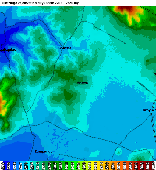
These maps also provides idea of topography and contour of this city, they are displayed at different zoom levels. More info about maps, scale and edge coordinates you can find below images.
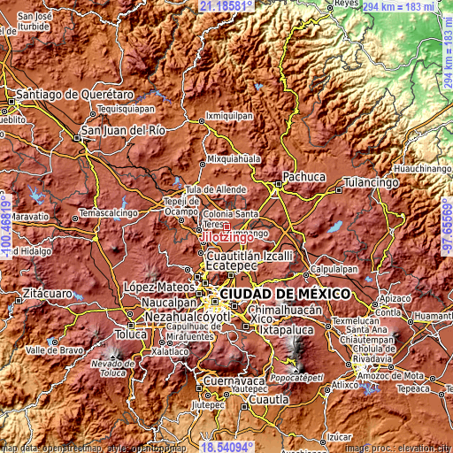
| \ | Map #1 | Map #2 | Topo.Map |
| Scale [m] | 2256..2370 m | 2202..2680 m | × |
| Scale [ft] | 7402..7776 ft | 7224..8793 ft | × |
| Average | 2298.4 m = 7541 ft | 2293.6 m = 7525 ft | × |
| Width | 9.19 km = 5.7 mi | 18.38 km = 11.4 mi | 294.1 km = 182.7 mi |
| Height | 9.19 km = 5.7 mi | 18.38 km = 11.4 mi | 294.1 km = 182.7 mi |
| ↑Max Latitude | 19.910214° | 19.951527° | 21.18581° |
| Latitude at center | 19.86889° | 19.86889° | 19.86889° |
| ↓Min Latitude | 19.827555° | 19.78621° | 18.54094° |
| ← Min Longitude | -99.105885° | -99.149831° | -100.46819° |
| Longitude center | -99.06194° | -99.06194° | -99.06194° |
| →Max Longitude | -99.017995° | -98.974049° | -97.65569° |
Nearby cities:
Cities around Jilotzingo sort by population:
• San Bartolo Cuautlalpan elevation 2269 m
8 km,  137°
137°
• Fraccionamiento la Trinidad 2269 m
4.9 km,  206°
206°
• Miguel Bocanegra 2281 m
5.8 km,  243°
243°
• Arbolada los Sauces 2265 m
6.2 km,  162°
162°
• Villas de la Laguna 2269 m
4.7 km,  218°
218°
• Hueypoxtla 2275 m
5.1 km,  345°
345°
• Santa María Cuevas 2317 m
3.9 km,  265°
265°
• San Miguel 2342 m
7.6 km, 269°
• Emiliano Zapata (San José Bata) 2305 m
7.4 km,  50°
50°
• Loma Larga (Barrio de Loma Larga) 2304 m
5.7 km, 268°
• Barrio de España 2327 m
2.2 km,  247°
247°
• Colonia Wenceslao Labra 2287 m
8 km,  234°
234°
Multilingual:
 En español:
Jilotzingo elevación 2328 m.
 En France:
Jilotzingo élévation 2328 m.
 Auf Deutsch:
Jilotzingo höhe über dem Meeresspiegel ist 2328 m.

Sources and notes:
- [note 1] Map square and city borders are not equal. Map elevation data is calculated only from area inside that square.
- [src 1] Elevation data from geonames database provided with same terms of usage.
- [src 2] The elevation map of Jilotzingo is generated using elevation data from NASA's 3 arcsec (90m) resolution SRTM data.
- [src 3] Base (background) map © OpenStreetMap contributors tiles are generated by Geofabrik and OpenTopoMap.
Copyright & License:
This Jilotzingo Elevation Map is licensed under CC BY-SA. You may reuse any part from this page, if you give a proper credit by linking to this URL:
 More info on terms of use page.