Santander Jiménez elevation
Santander Jiménez (Tamaulipas, Jiménez), Mexico elevation is 113 meters and Santander Jiménez elevation in feet is 371 ft above sea level [src 1]. Santander Jiménez is a seat of a second-order administrative division (feature code) with elevation that is 1201 meters (3940 ft) smaller than average city elevation in Mexico.
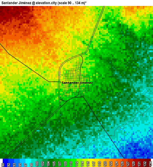
Below is the Elevation map of Santander Jiménez, which displays elevation range with different colors. Scale of the first map is from 90 to 134 m (295 to 440 ft) with average elevation of 109.4 meters (=359 ft) [note 1]
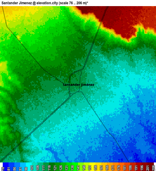
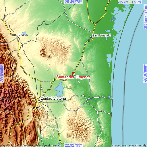
These maps also provides idea of topography and contour of this city, they are displayed at different zoom levels. More info about maps, scale and edge coordinates you can find below images.
| \ | Map #1 | Map #2 | Topo.Map |
| Scale [m] | 90..134 m | 76..206 m | × |
| Scale [ft] | 295..440 ft | 249..676 ft | × |
| Average | 109.4 m = 359 ft | 117.4 m = 385 ft | × |
| Width | 8.91 km = 5.5 mi | 17.83 km = 11.1 mi | 285.2 km = 177.2 mi |
| Height | 8.91 km = 5.5 mi | 17.83 km = 11.1 mi | 285.2 km = 177.2 mi |
| ↑Max Latitude | 24.256892° | 24.296951° | 25.49278° |
| Latitude at center | 24.21682° | 24.21682° | 24.21682° |
| ↓Min Latitude | 24.176736° | 24.136639° | 22.92795° |
| ← Min Longitude | -98.528275° | -98.572221° | -99.89058° |
| Longitude center | -98.48433° | -98.48433° | -98.48433° |
| →Max Longitude | -98.440385° | -98.396439° | -97.07808° |
Nearby cities:
Cities around Santander Jiménez sort by population:
• Soto la Marina elevation 20 m
57.3 km,  150°
150°
• Abasolo 71 m
20.9 km, 147°
• Nueva Villa de Padilla 156 m
46.3 km,  246°
246°
• Barretal 201 m
66.7 km,  257°
257°
• Guadalupe Victoria 70 m
29.5 km,  120°
120°
• Guemes 170 m
62.5 km,  237°
237°
• Nicolás Bravo 51 m
33.1 km,  136°
136°
• San Carlos 453 m
61.6 km,  311°
311°
• Tampiquito 48 m
51.8 km, 145°
• Cruillas 234 m
60.3 km,  354°
354°
• Casas 160 m
60.2 km,  205°
205°
• San Nicolás 691 m
63.5 km,  326°
326°
Multilingual:
 En español:
Santander Jiménez elevación 113 m.
 En France:
Santander Jiménez élévation 113 m.
 Auf Deutsch:
Santander Jiménez höhe über dem Meeresspiegel ist 113 m.

Sources and notes:
- [note 1] Map square and city borders are not equal. Map elevation data is calculated only from area inside that square.
- [src 1] Elevation data from geonames database provided with same terms of usage.
- [src 2] The elevation map of Santander Jiménez is generated using elevation data from NASA's 3 arcsec (90m) resolution SRTM data.
- [src 3] Base (background) map © OpenStreetMap contributors tiles are generated by Geofabrik and OpenTopoMap.
Copyright & License:
This Santander Jiménez Elevation Map is licensed under CC BY-SA. You may reuse any part from this page, if you give a proper credit by linking to this URL:
 More info on terms of use page.