Tamiahua elevation
Tamiahua (Veracruz), Mexico elevation is 4 meters and Tamiahua elevation in feet is 13 ft above sea level [src 1]. Tamiahua is a seat of a second-order administrative division (feature code) with elevation that is 1310 meters (4298 ft) smaller than average city elevation in Mexico.
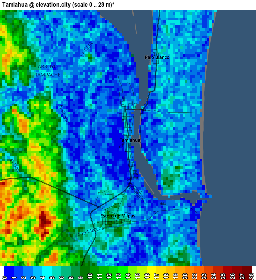
Below is the Elevation map of Tamiahua, which displays elevation range with different colors. Scale of the first map is from 0 to 28 m (0 to 92 ft) with average elevation of 6.2 meters (=20 ft) [note 1]
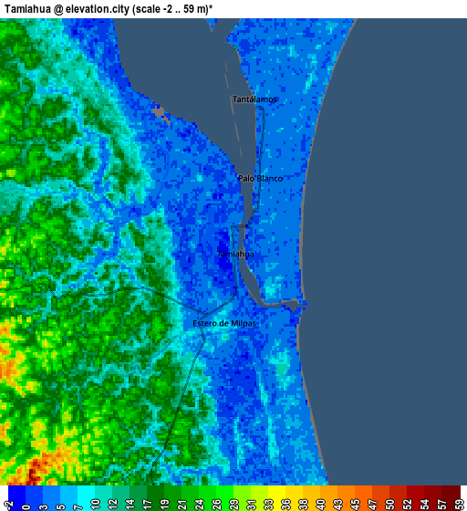
These maps also provides idea of topography and contour of this city, they are displayed at different zoom levels. More info about maps, scale and edge coordinates you can find below images.
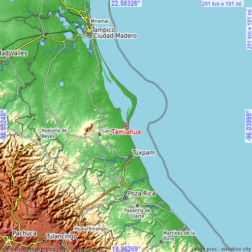
| \ | Map #1 | Map #2 | Topo.Map |
| Scale [m] | 0..28 m | -2..59 m | × |
| Scale [ft] | 0..92 ft | -7..194 ft | × |
| Average | 6.2 m = 20 ft | 11.7 m = 38 ft | × |
| Width | 9.11 km = 5.7 mi | 18.21 km = 11.3 mi | 291.4 km = 181.1 mi |
| Height | 9.11 km = 5.7 mi | 18.21 km = 11.3 mi | 291.4 km = 181.1 mi |
| ↑Max Latitude | 21.319754° | 21.360686° | 22.58326° |
| Latitude at center | 21.27881° | 21.27881° | 21.27881° |
| ↓Min Latitude | 21.237855° | 21.196889° | 19.96269° |
| ← Min Longitude | -97.490145° | -97.534091° | -98.85245° |
| Longitude center | -97.4462° | -97.4462° | -97.4462° |
| →Max Longitude | -97.402255° | -97.358309° | -96.03995° |
Nearby cities:
Cities around Tamiahua sort by population:
• Cerro Azul elevation 141 m
32 km,  252°
252°
• Naranjos 62 m
26.2 km,  287°
287°
• Chinampa de Gorostiza 106 m
31.2 km, 286°
• Colonia las Flores 59 m
27.2 km, 289°
• Amatlán 176 m
32.8 km,  281°
281°
• Temapache 233 m
31.2 km,  220°
220°
• Estero de Milpas 6 m
2.8 km,  189°
189°
• Banderas 26 m
32.5 km,  170°
170°
• Zacamixtle 142 m
28.7 km,  263°
263°
• El Anono 178 m
21.9 km, 263°
• Saladero 2 m
19 km,  327°
327°
• Ojite Rancho Nuevo 37 m
35.4 km, 193°
Multilingual:
 En español:
Tamiahua elevación 4 m.
 En France:
Tamiahua élévation 4 m.


Sources and notes:
- [note 1] Map square and city borders are not equal. Map elevation data is calculated only from area inside that square.
- [src 1] Elevation data from geonames database provided with same terms of usage.
- [src 2] The elevation map of Tamiahua is generated using elevation data from NASA's 3 arcsec (90m) resolution SRTM data.
- [src 3] Base (background) map © OpenStreetMap contributors tiles are generated by Geofabrik and OpenTopoMap.
Copyright & License:
This Tamiahua Elevation Map is licensed under CC BY-SA. You may reuse any part from this page, if you give a proper credit by linking to this URL:
 More info on terms of use page.