Tasquillo elevation
Tasquillo (Hidalgo), Mexico elevation is 1649 meters and Tasquillo elevation in feet is 5410 ft above sea level [src 1]. Tasquillo is a populated place (feature code) with elevation that is 335 meters (1099 ft) bigger than average city elevation in Mexico.
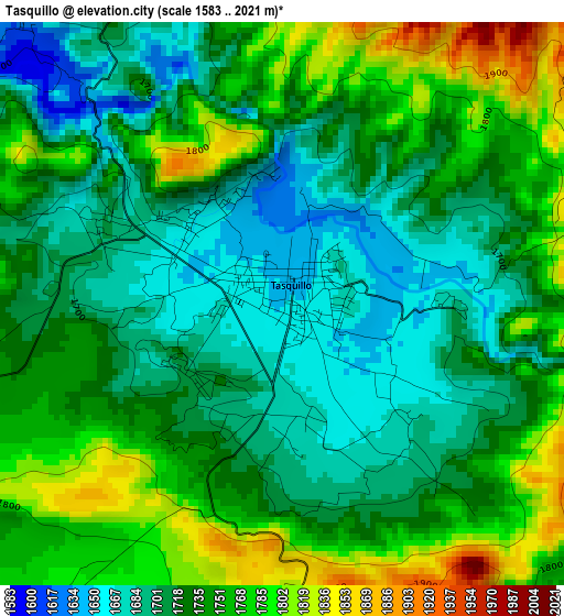
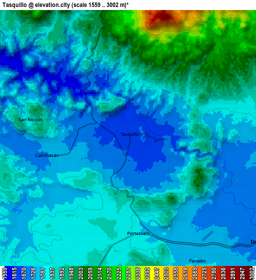
Below is the Elevation map of Tasquillo, which displays elevation range with different colors. Scale of the first map is from 1583 to 2021 m (5194 to 6631 ft) with average elevation of 1733.2 meters (=5686 ft) [note 1]
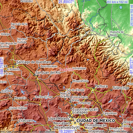
These maps also provides idea of topography and contour of this city, they are displayed at different zoom levels. More info about maps, scale and edge coordinates you can find below images.
| \ | Map #1 | Map #2 | Topo.Map |
| Scale [m] | 1583..2021 m | 1559..3002 m | × |
| Scale [ft] | 5194..6631 ft | 5115..9849 ft | × |
| Average | 1733.2 m = 5686 ft | 1830.7 m = 6006 ft | × |
| Width | 9.15 km = 5.7 mi | 18.3 km = 11.4 mi | 292.8 km = 181.9 mi |
| Height | 9.15 km = 5.7 mi | 18.3 km = 11.4 mi | 292.8 km = 181.9 mi |
| ↑Max Latitude | 20.589504° | 20.630637° | 21.85937° |
| Latitude at center | 20.54836° | 20.54836° | 20.54836° |
| ↓Min Latitude | 20.507205° | 20.466039° | 19.22601° |
| ← Min Longitude | -99.357465° | -99.401411° | -100.71977° |
| Longitude center | -99.31352° | -99.31352° | -99.31352° |
| →Max Longitude | -99.269575° | -99.225629° | -97.90727° |
Nearby cities:
Cities around Tasquillo sort by population:
• Ixmiquilpan elevation 1711 m
12.7 km,  127°
127°
• Panales 1780 m
10 km,  150°
150°
• Dios Padre 1746 m
14.9 km, 128°
• Portezuelo 1784 m
6.9 km,  173°
173°
• Caltimacan 1722 m
6 km,  257°
257°
• Alfajayucan 1880 m
16 km,  193°
193°
• El Nith 1751 m
14.3 km,  118°
118°
• Zocea 1887 m
13.1 km,  200°
200°
• El Barrido 1774 m
16.8 km, 130°
• Cantinela 1757 m
14.7 km, 133°
• Santa María Xigui 1852 m
10.2 km, 198°
• Orizabita 1915 m
11.6 km,  70°
70°
Multilingual:
 En español:
Tasquillo elevación 1649 m.
 En France:
Tasquillo élévation 1649 m.
 Auf Deutsch:
Tasquillo höhe über dem Meeresspiegel ist 1649 m.

Sources and notes:
- [note 1] Map square and city borders are not equal. Map elevation data is calculated only from area inside that square.
- [src 1] Elevation data from geonames database provided with same terms of usage.
- [src 2] The elevation map of Tasquillo is generated using elevation data from NASA's 3 arcsec (90m) resolution SRTM data.
- [src 3] Base (background) map © OpenStreetMap contributors tiles are generated by Geofabrik and OpenTopoMap.
Copyright & License:
This Tasquillo Elevation Map is licensed under CC BY-SA. You may reuse any part from this page, if you give a proper credit by linking to this URL:
 More info on terms of use page.