Ixmiquilpan elevation
Ixmiquilpan (Hidalgo), Mexico elevation is 1711 meters and Ixmiquilpan elevation in feet is 5614 ft above sea level [src 1]. Ixmiquilpan is a seat of a second-order administrative division (feature code) with elevation that is 397 meters (1302 ft) bigger than average city elevation in Mexico.
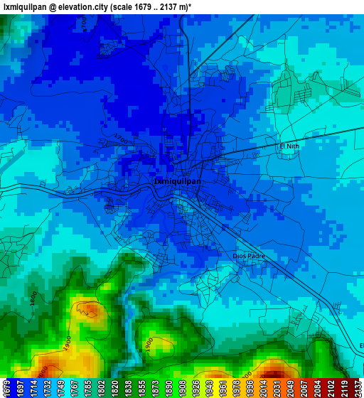
Below is the Elevation map of Ixmiquilpan, which displays elevation range with different colors. Scale of the first map is from 1679 to 2137 m (5509 to 7011 ft) with average elevation of 1755.8 meters (=5760 ft) [note 1]
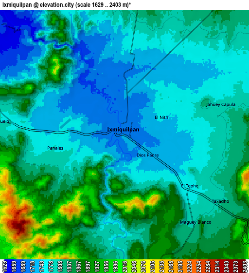
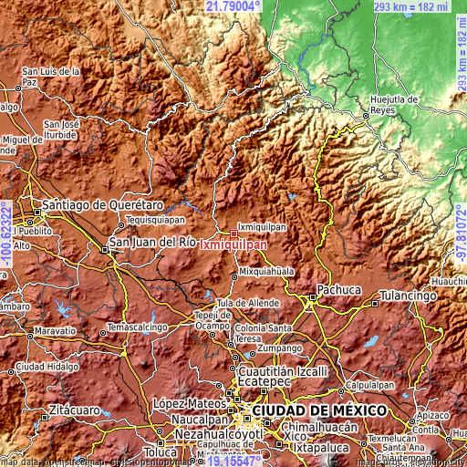
These maps also provides idea of topography and contour of this city, they are displayed at different zoom levels. More info about maps, scale and edge coordinates you can find below images.
| \ | Map #1 | Map #2 | Topo.Map |
| Scale [m] | 1679..2137 m | 1629..2403 m | × |
| Scale [ft] | 5509..7011 ft | 5344..7884 ft | × |
| Average | 1755.8 m = 5760 ft | 1812.9 m = 5948 ft | × |
| Width | 9.15 km = 5.7 mi | 18.31 km = 11.4 mi | 292.9 km = 182 mi |
| Height | 9.16 km = 5.7 mi | 18.31 km = 11.4 mi | 293 km = 182.1 mi |
| ↑Max Latitude | 20.519573° | 20.560724° | 21.79004° |
| Latitude at center | 20.47841° | 20.47841° | 20.47841° |
| ↓Min Latitude | 20.437236° | 20.396052° | 19.15547° |
| ← Min Longitude | -99.260915° | -99.304861° | -100.62322° |
| Longitude center | -99.21697° | -99.21697° | -99.21697° |
| →Max Longitude | -99.173025° | -99.129079° | -97.81072° |
Nearby cities:
Cities around Ixmiquilpan sort by population:
• Panales elevation 1780 m
5.3 km,  259°
259°
• El Tephé 1754 m
5.5 km,  127°
127°
• Dios Padre 1746 m
2.2 km, 133°
• Maguey Blanco 1821 m
7.8 km,  141°
141°
• Portezuelo 1784 m
9.3 km,  275°
275°
• El Nith 1751 m
2.8 km,  68°
68°
• Taxadho 1809 m
8.6 km, 125°
• La Estancia 1906 m
9.9 km,  173°
173°
• Pueblo Nuevo 1781 m
5.9 km,  116°
116°
• El Barrido 1774 m
4.1 km, 138°
• Cantinela 1757 m
2.4 km,  163°
163°
• Bangandhó 1795 m
7.1 km,  86°
86°
Multilingual:
 En español:
Ixmiquilpan elevación 1711 m.
 En France:
Ixmiquilpan élévation 1711 m.
 Auf Deutsch:
Ixmiquilpan höhe über dem Meeresspiegel ist 1711 m.

Sources and notes:
- [note 1] Map square and city borders are not equal. Map elevation data is calculated only from area inside that square.
- [src 1] Elevation data from geonames database provided with same terms of usage.
- [src 2] The elevation map of Ixmiquilpan is generated using elevation data from NASA's 3 arcsec (90m) resolution SRTM data.
- [src 3] Base (background) map © OpenStreetMap contributors tiles are generated by Geofabrik and OpenTopoMap.
Copyright & License:
This Ixmiquilpan Elevation Map is licensed under CC BY-SA. You may reuse any part from this page, if you give a proper credit by linking to this URL:
 More info on terms of use page.