Tecpatán elevation
Tecpatán (Chiapas), Mexico elevation is 317 meters and Tecpatán elevation in feet is 1040 ft above sea level [src 1]. Tecpatán is a seat of a second-order administrative division (feature code) with elevation that is 997 meters (3271 ft) smaller than average city elevation in Mexico.
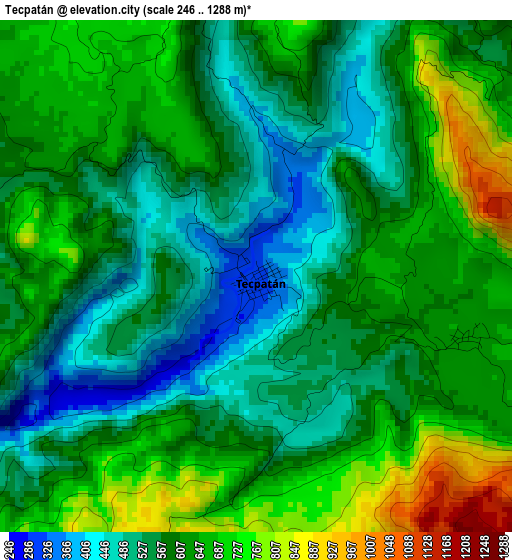
Below is the Elevation map of Tecpatán, which displays elevation range with different colors. Scale of the first map is from 246 to 1288 m (807 to 4226 ft) with average elevation of 600.7 meters (=1971 ft) [note 1]
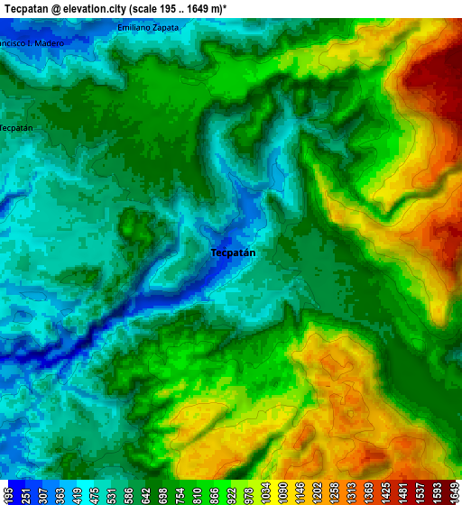
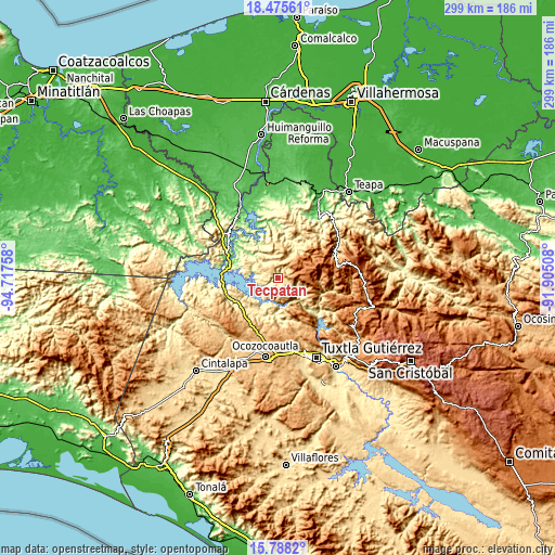
These maps also provides idea of topography and contour of this city, they are displayed at different zoom levels. More info about maps, scale and edge coordinates you can find below images.
| \ | Map #1 | Map #2 | Topo.Map |
| Scale [m] | 246..1288 m | 195..1649 m | × |
| Scale [ft] | 807..4226 ft | 640..5410 ft | × |
| Average | 600.7 m = 1971 ft | 736.3 m = 2416 ft | × |
| Width | 9.34 km = 5.8 mi | 18.68 km = 11.6 mi | 298.8 km = 185.7 mi |
| Height | 9.34 km = 5.8 mi | 18.68 km = 11.6 mi | 298.8 km = 185.7 mi |
| ↑Max Latitude | 17.17875° | 17.22073° | 18.47561° |
| Latitude at center | 17.13676° | 17.13676° | 17.13676° |
| ↓Min Latitude | 17.094761° | 17.052752° | 15.7882° |
| ← Min Longitude | -93.355275° | -93.399221° | -94.71758° |
| Longitude center | -93.31133° | -93.31133° | -93.31133° |
| →Max Longitude | -93.267385° | -93.223439° | -91.90508° |
Nearby cities:
Cities around Tecpatán sort by population:
• Copainalá elevation 430 m
11.7 km,  114°
114°
• Ocotepec 1476 m
18.5 km,  57°
57°
• Coapilla 1639 m
16.1 km,  92°
92°
• Luis Espinoza 207 m
11.9 km,  277°
277°
• Ángel Albino Corzo (Guadalupe) 623 m
4 km, 106°
• San Pablo Huacano 1656 m
12.8 km, 59°
• Francisco I. Madero 290 m
11.9 km,  315°
315°
• Adolfo López Mateos 577 m
19.9 km,  296°
296°
• Las Maravillas 287 m
19.7 km,  182°
182°
• Benito Juárez 1189 m
6.6 km, 86°
• Nuevo Naranjo 208 m
13.1 km, 278°
• San Miguel la Sardina 495 m
18 km,  345°
345°
Multilingual:
 En español:
Tecpatán elevación 317 m.
 En France:
Tecpatán élévation 317 m.
 Auf Deutsch:
Tecpatán höhe über dem Meeresspiegel ist 317 m.

Sources and notes:
- [note 1] Map square and city borders are not equal. Map elevation data is calculated only from area inside that square.
- [src 1] Elevation data from geonames database provided with same terms of usage.
- [src 2] The elevation map of Tecpatán is generated using elevation data from NASA's 3 arcsec (90m) resolution SRTM data.
- [src 3] Base (background) map © OpenStreetMap contributors tiles are generated by Geofabrik and OpenTopoMap.
Copyright & License:
This Tecpatán Elevation Map is licensed under CC BY-SA. You may reuse any part from this page, if you give a proper credit by linking to this URL:
 More info on terms of use page.