Santiago Tenango elevation
Santiago Tenango (Puebla, General Felipe Ángeles), Mexico elevation is 2292 meters and Santiago Tenango elevation in feet is 7520 ft above sea level [src 1]. Santiago Tenango is a populated place (feature code) with elevation that is 978 meters (3209 ft) bigger than average city elevation in Mexico.
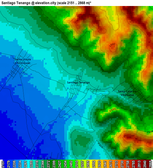
Below is the Elevation map of Santiago Tenango, which displays elevation range with different colors. Scale of the first map is from 2151 to 2868 m (7057 to 9409 ft) with average elevation of 2371.1 meters (=7779 ft) [note 1]
These maps also provides idea of topography and contour of this city, they are displayed at different zoom levels. More info about maps, scale and edge coordinates you can find below images.
| \ | Map #1 | Map #2 | Topo.Map |
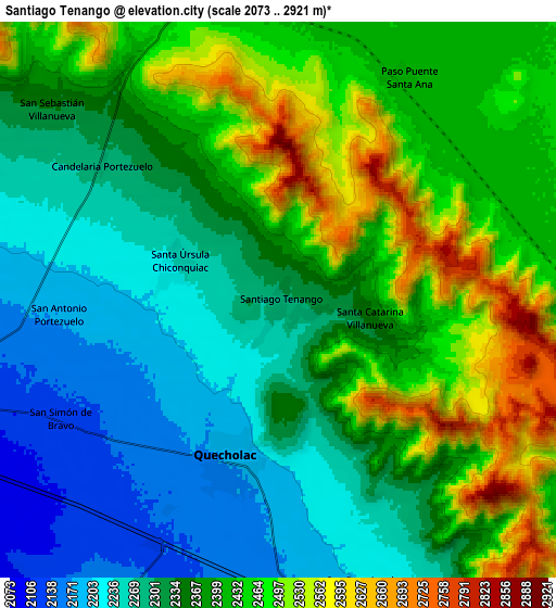
| Scale [m] | 2151..2868 m | 2073..2921 m | × |
| Scale [ft] | 7057..9409 ft | 6801..9583 ft | × |
| Average | 2371.1 m = 7779 ft | 2372.8 m = 7785 ft | × |
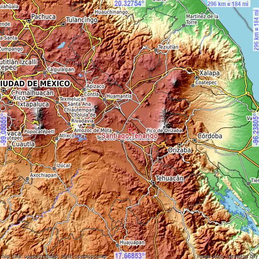
| Width | 9.24 km = 5.7 mi | 18.48 km = 11.5 mi | 295.7 km = 183.7 mi |
| Height | 9.24 km = 5.7 mi | 18.48 km = 11.5 mi | 295.7 km = 183.7 mi |
| ↑Max Latitude | 19.044895° | 19.08643° | 20.32754° |
| Latitude at center | 19.00335° | 19.00335° | 19.00335° |
| ↓Min Latitude | 18.961795° | 18.920229° | 17.66853° |
| ← Min Longitude | -97.688245° | -97.732191° | -99.05055° |
| Longitude center | -97.6443° | -97.6443° | -97.6443° |
| →Max Longitude | -97.600355° | -97.556409° | -96.23805° |
Nearby cities:
Cities around Santiago Tenango sort by population:
• Palmarito Tochapan elevation 2157 m
11.4 km,  176°
176°
• Quecholac 2173 m
5.6 km,  195°
195°
• San Sebastián Villanueva 2335 m
10.2 km,  309°
309°
• San Simón 2128 m
8.2 km,  240°
240°
• San Antonio Portezuelo 2175 m
7.3 km,  266°
266°
• Tuzuapan 2140 m
11.6 km,  191°
191°
• San Pablo de las Tunas 2176 m
6.9 km,  262°
262°
• La Compañia 2124 m
9 km,  246°
246°
• Santa Catarina Villanueva 2359 m
3.1 km,  98°
98°
• San Bartolomé 2202 m
9.9 km,  164°
164°
• Guadalupe Victoria 2443 m
12 km,  19°
19°
• Candelaria Portezuelo 2280 m
7.3 km, 305°
Multilingual:
 En español:
Santiago Tenango de Reyes, Santiago Tenango elevación 2292 m.
 En France:
Santiago Tenango élévation 2292 m.
 Auf Deutsch:
Santiago Tenango höhe über dem Meeresspiegel ist 2292 m.

Sources and notes:
- [note 1] Map square and city borders are not equal. Map elevation data is calculated only from area inside that square.
- [src 1] Elevation data from geonames database provided with same terms of usage.
- [src 2] The elevation map of Santiago Tenango is generated using elevation data from NASA's 3 arcsec (90m) resolution SRTM data.
- [src 3] Base (background) map © OpenStreetMap contributors tiles are generated by Geofabrik and OpenTopoMap.
Copyright & License:
This Santiago Tenango Elevation Map is licensed under CC BY-SA. You may reuse any part from this page, if you give a proper credit by linking to this URL:
 More info on terms of use page.